 Jaisalmer is noted for its rich historical tradition as well as for its scenic locales. It has a plethora of dainty locales, which has cast a charm amongst its visitors who visit the city more than once. The quick popularity of Jaisalmer city peps up all the travel freaks to be accustomed with the details of geography of Jaisalmer.
The district of Jaisalmer is situated within a rectangle stretching between `26°. 4` -28°. 23` North parallel and 69°. 20`-72°.42` east meridians`. Jaisalmer district is the largest one in Rajasthan and also one of the largest districts of the whole country.
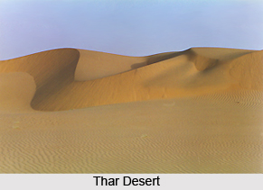
The length of the Jaisalmer district is 186 Kms. Its breadth is 270 Kms. Several other districts of Jaisalmer form its boundaries. As per the recent topographical segregation, Bikaner lies on the northern side of the district of Jaisalmer. On the eastern side the district of Jaisalmer is bounded by Jodhpur district and also Barmer district lies on the southern part. Jaisalmer District is a part of the Great Thar Desert, which lays out in India and Pakistan borders. The district is sandy, parched and scorched. The piece of land lying around, with a radius of nearly 60 kms is thronged with stones and rocks. The area is infertile, undulated with its popular sand dunes and slopes. Negligible rainfall occurs here. In the whole of Jaisalmer district one could not find any perennial river. Low underground water level is available. Strategically it covers an area of 38,401 sq. kms which is equivalent to the size of the whole of Kerala state of India.
The geography of Jaisalmer district is enriched by its myriads of wild animals and birds. The region is characterized by sparse vegetation. Trees like Bavla, Khezada, Lora, Van, Rohida, Phog, Jal, Kumbhar, Neem, Babul and many more are grown here. Only a handful of orchards are seen. Coming across any grassland or lawns is next to impossible. In order to collect water and food wild animals roam about here and there. Cow, sheep, camel, goat, jackals and boar deserve to be mentioning. Venomous snakes are special attraction and are commonly find in the district. The district is thronged by a variety of beautiful birds. The district is filled with cheeping of wonderful birds thereby making it full of life and fascinating. Pigeon, peacock, parrot, crow are the names of some of these birds . Special attraction is the white Palam birds. In Jaisalmer district, one finds huge Indian bustards. There was a time when they used to reside in large numbers in the Thar Desert, Now these bustards are on the verge of extinction. Moreover few domestic birds like cocks and hens also are found.
Climatic condition also is a key element, which enables one to identify the geography of Jaisalmer district in a much better way. It is dry and parched. In fact the people of
Jaisalmer district witness hot and sultry summer. Winter season is cold. There is scanty rainfall. During summer maximum temperature rises to 49.2 degree Celsius. During chilly days of winter temperature drops down to as low as 1 degree Celsius. Situation is not rare when the temperature varies from morning to noon and the late midnight. Total average rainfall has been measured to be only 16.4 cms.


