 Gondia district is situated along the north-eastern part of the state of Maharashtra. It was carved out of the Bhandara district. For administrative purposes the district is divided into two subdivisions namely Gondia and Deori, which are further divided into four talukas. Spread over an area of 5425 sq. km., 53 percent of the district is covered with forests. The nearest airport is at Nagpur at a distance of 130 km. It is located near N H 6, which helps in keeping it connected with major cities like Nagpur, Raipur, Hyderabad etc. Also known as the Rice bowl of Maharashtra, the district has a primarily agriculture-based economy. Given below are further details regarding the district of Gondia.
Location of Gondia District
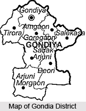
Gondia district lies between the north latitudes of 20.39 and 21.38 and east longitudes of 89.27 and 82.42. It is surrounded by Gadchiroli district in the south, Bhandara district in the west, Balaghat district of Madhya Pradesh in the north and Rajnandgaon district of Chhatisgarh in the east. The district headquarter is situated at Gondia situated on Mumbai- Kolkata railway route which is 1060 Km from Mumbai, capital of state.
Geography of Gondia District
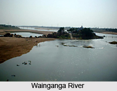 The district witnesses extreme variations in temperature with very hot summers and very cold winters. Gondia district receives rainfall from South- Western winds mainly in the months of June, July, August and September. July and August are the months during which the maximum rainfall as well as maximum continuous rainfall occurs. The region has an average relative humidity of 62 percent. It has a Southern tropical dry deciduous eco-region and is the habitat of a variety of wildlife. The district is well connected to the other places in the state. The Wainganga River is the largest and most important river and it enters into district through north east direction. Its total length in the district is 200km.and it flows to the south in the Chandrapur district. It has perennial flow. The rivers like Bagh, Chulbandh, Panghodi Suz, Gadhavi, Chandan, Bavanthadi are the tributaries of river Wainganga.
Culture of Gondia District
As per the Census of 2001, the total population of the district is 1200151. This includes 598447 males and 601704 females. Density of Population is 247 per Sq.Km. The population of schedule tribes is 309822 and the population of schedule caste is 355484. The tribals in the district have their own culture. They reside in the dense forests of the district .They worship their own God known as "Persa Pen". The Rela dance is performed by them on auspicious occasions as well as when new crops are grown. The other popular dance form among the tribals is the Dhol. The major festivals celebrated by them are Holi, Dussehra and Diwali. A number of festivals are celebrated in the district in general, as well, such as the Ganapati festival, Dussehra, Diwali and Holi. In some areas nataks are arranged along with some other cultural programs on Diwali and other festivities. The major languages spoken in the district are the Marathi language, Hindi language, Chhatisgadi and Gondi language. Dander, Gondi dance, Bhajan and Keertan are the major folk-arts.
Economy of Gondia District
Being dominantly rural, agriculture is the main occupation of the people living here. Paddy is the main crop that is cultivated here and hence the district is also known as the `Rice Bowl of Maharastra`. 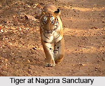 The city of Gondia has many rice mills because of which it is also known as the rice city. The other crops cultivated here are wheat, jowar, tur, linseed, moong, udad and mustard. There are no large-scale industries in the entire district.
Tourism in Gondia District
Gondia district is an idyllic tourist destination with its vast unending stretches of forests, exotic mountain ranges and rural landscape unfettered by civilization. Kachargadh is located at a distance of 55 km. from Gondia and is a popular tourist destination because of the 25000 year old natural caves situated here. Nagra is dotted with ancient temples that impart an antique look to the place and is also a site of archaeological importance. Nagzira Sanctuary is situated 40 km. from Gondia in Sadak Arjuni Tahsil and is the home of thirty-four species of wild animals. Chulbandh is situated twenty-five kilometres from Gondia in Goregaon Tahsil and is a paradise for all nature lovers owing to its serenity. Navegaon National Park, situated amidst the exquisite Nishani Range in Morgaon Arjuni Tahasil is another exciting tourist destination. It is best suited for trekking and bird watching. Kanha Tiger Reserve in Mandla district of Madhya Pradesh is located at a distance of 110 km. from Gondia. Devotees visit the temple of Mando Devi especially during navratra and the temple of Suryadeo is situated on a nearby hillock.


