Home > Travel > States of India > Upper Dibang Valley District
Upper Dibang Valley District
The Upper Dibang Valley District is one of the largest districts of the north eastern state of Arunachal Pradesh and is the least populated district in India.

Share this Article:

Upper Dibang Valley District, Arunachal Pradesh
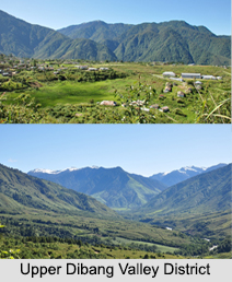
With undulated-rugged mountains and breath-taking green valleys, deep gorges, enchanting waterfalls and natural lakes, the Upper Dibang Valley District is one of the largest districts of Arunachal Pradesh. The valley district has been named after the Dibang River or the Talons as the tribal group of Mishims call it.

History of Upper Dibang Valley District
Prior to June 1980, the Upper Dibang Valley District was a part of the Lohit District and on December 16th, 2001 the Dibang Valley district was bifurcated into Upper Dibang Valley district and Lower Dibang Valley district.

Geography of Upper Dibang Valley District
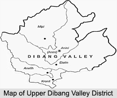
Spreading over a total area of 9, 129 sq. km and known to be one of the largest districts of Arunachal Pradesh, the Upper Dibang Valley District contains the northernmost point of the Northeast India. The Dibang River originates in the Tibetan mountains and flows through the length of the Upper Dibang Valley District. The capital of the district is Anini, which is the northernmost district capital in north east India.

Upper Dibang Valley District, Arunachal PradeshThere is only one Arunachal Pradesh Legislative Assembly constituency in this district which is Anini and is part of the Arunachal East Lok Sabha constituency.

Demographics of Upper Dibang Valley District
As per the reports of Census India 2011, the total population of the district is 7, 948 and is the most sparsely populated district in the country. The Upper Dibang Valley District has a population density of 0.8 inhabitants per sq. km. The population growth over the decade of 2001 to 2011 has been 9.3 percent and has a sex ratio of 808 females for every 1000 males. The literacy rate of the Upper Dibang Valley District is 64.8 percent and the major population of this district mainly consist of the Mishmis. The majority religion here is Hinduism consisting of about 50 percent of the total population.

The languages spoken here in this Upper Dibang Valley District include Mishmi, a Sino-Tibetan tongue with approximately 25000 speakers, written in both the Tibetan and Latin scripts.

Wildlife of Upper Dibang Valley District
The Upper Dibang Valley District is rich in flora and fauna with rare mammals such as Mishmi takin, Red goral and Gongshan muntjac and rare birds like the Sclater`s Monal. The flying squirrel has been recently discovered from this district and has been named as Mishmi Hills Giant Flying Squirrel. In 1991, the Upper Dibang Valley District became home to the Dibang Wildlife Sanctuary, which has an area of 4,149 sq. km.


Share this Article:

Related Articles

More Articles in States of India


East Indian States
East Indian States comprises of Bihar, Jharkhand, West Bengal, Odisha and also the Union Territory of Andaman and Nicobar Islands. It defines the cultural heritage, rich historical background and the linguistic unity.
Erode District
Erode District is one of the districts in the state of Tamil Nadu. The district of Erode is having a land-locked area with no sea coast.
Purnia District in Bihar
Purnia District is located in Bihar and extends from River Ganga to Nepal. The district has a rich Hindu history and glorious past.
South Delhi District
South Delhi District is the third largest district of Delhi as far as its area is concerned. South Delhi District is known for its economic, historical, cultural and social significance.
North Indian States
North Indian States formed the cultural and religious unity in spite of having many foreign invasion and the political disturbances from the early era till the British gained supremacy in Indian sub continent.
Kendujhar District
Kendujhar District, spread over an area of 8,240 sq kms, is as varied as the whole of Orissa with waterfalls roaring gorges, mountains and minerals. The manifold expressions of nature in Kendujhar District are considered as unique.
Hooghly district
Hooghly District along the bank of the river Hooghly is one of the principal trading ports of West Bengal.
Districts of South Tamil Nadu
Districts of South Tamil Nadu consist of many tourism destinations like archaeological sites and the history of Pandyas and Cholas. Considering their proximity to the sea, many districts also boast of serene beaches and coastal beauty.
Flora of Arunachal Pradesh
Flora of Arunachal Pradesh includes infinite species and is a subject of great interests for the botanists.
Districts of South Gujarat
Districts of South Gujarat are the epicenter of Jain pilgrimages and the early Hindu kingdoms.
North West States of India
North West States of India consist of three states, which are Rajasthan, Punjab and Haryana. All of them are culturally and traditionally diverse and they have been ruled by different dynasties in historical time.
Geography Of Chittoor District
Geography of Chittoor district is spread along the topography of the land which is divided into two natural divisions; Chittoor has a dry and healthy climate.
Districts of North Rajasthan
District of Northern part of Rajasthan is dotted with ancient forts and medieval villages.
Districts of North Odisha
District of North Odisha has Bengal boundary and shares the same culture. These are reachable if one pays a weekend visit to Digha.
Districts of West Bihar
Districts of West Bihar is comprised of medieval monuments that were built by the different governors of Mughal era.
Districts of South Haryana
Districts of South Haryana consists of many cities of industrial excellence. These districts are dotted with popular tourism destinations.
Medieval History of Assam
Medieval history of Assam narrates the advent and rule of a number of kingdoms in the region. The prominent dynasties of the kingdom left an everlasting imprint on the socio cultural heritage of India.
Geography of Meghalaya
The suitable climate, highland plateaus, rivers and the flora and fauna together forms the geography of Meghalaya.
Districts of Rayalaseema
Districts of Rayalaseema in Andhra Pradesh state has urban population and rural settlements as well.
Districts of South Punjab
Districts of Southern part of Punjab depict medieval history of Punjab and the rise of Sikhs.