
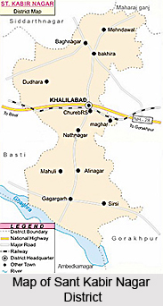
 Sant Kabir Nagar District is a newly created district in the eastern belt of Uttar Pradesh. Sant Kabir Nagar District is one of the three districts of Basti Division. The district is bounded by Gorakhpur in the east, by Basti in the west, Siddharthnagar in the north and by Ambedkar Nagar in the south. According to the district statistical department Sant Kabir Nagar District covers an area of around 1659.15 sq kms.
Sant Kabir Nagar District
Sant Kabir Nagar District is one of the administrative districts of Uttar Pradesh with its headquarters at Khalilabad. Sant Kabir Nagar District was formed in the year 1997.
Introduction
Sant Kabir Nagar District is a newly created district in the eastern belt of Uttar Pradesh. Sant Kabir Nagar District is one of the three districts of Basti Division. The district is bounded by Gorakhpur in the east, by Basti in the west, Siddharthnagar in the north and by Ambedkar Nagar in the south. According to the district statistical department Sant Kabir Nagar District covers an area of around 1659.15 sq kms.History of Sant Kabir Nagar District
History of Sant Kabir Nagar District suggests the origin of its name. Sant Kabir Nagar District came to be known by its present name on account of Kabir, the Bhakti Saint and philosopher, who lived at Maghar in the district. Sant Kabir Nagar District was created on 5th of September, 1997 from Basti District including 131 villages from tehsil Basti, and 161 from tehsil Bansi of district Siddharthnagar.
Geography of Sant Kabir Nagar District
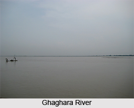 Geography of Sant Kabir Nagar District, in spite of its apparent uniformity of aspect, is divided into several distinct tracts. These divisions are the low valley of Ghaghara River in the south, extending from that river to its tributary, the Kuwana; the central upland, between the latter and Rapti River; and the low and ill-drained paddy belt between Rapti and others. The district has two main river systems namely, the Ghaghara and Rapti, both of which ultimately form a part of the great Gangetic system. The other streams of the district include Kuwana, its tributaries, Rawai, Manwar and Katnehia. Ami is a tributary of Rapti. Ghaghara forms the southern boundary of the district.
The climate of Sant Kabir Nagar District is more composed than the adjoining districts in the south. The year may be divided into four seasons. The winter season, from mid-November to February, this is followed by the summer season lasting till about the middle of June. The period from mid-June to the end of September constitutes the south-west monsoon season. October to mid-November is the post monsoon or the transition period. The average annual rainfall in the district is 1166 mm. During the winter seasons the mean minimum temperature is about 9 degree Celsius and the mean maximum 23 degree Celsius while during the summer seasons the minimum is about 25 degree Celsius and mean maximum is about 44 degree Celsius. In the post monsoon seasons the relative humidity is high. Winds are in general very light with a slight increase in force during the late summer and monsoon seasons.
Geography of Sant Kabir Nagar District also includes numerous lakes and several of them are of considerable size. They are most commonly formed by the changes in the river channels. The largest and the most celebrated lake in the district is the Bakhira or Badhanchh Tal, also known as the Moti Jhil, which lies on the eastern borders of the district between Bakhira and Mehdawal. The district is underlain by Quaternary alluvium comprising various gravel, Kanker and clay. Substantial deposits of Kanker are available in the tehsil of Harriya only. The Alluvium can be classified into two groups, older alluvium and newer alluvium. Older alluvium is of middle Pleistocene age and generally occupies high ground which is not affected by floods during the rainy season. On the other hand, the newer alluvium covers the lower height and is mainly conferred to the flood plains along the river channels.
In the former days a large part of the district was covered with forest of Sal and other trees, but since then most of it has been cleared and brought under the plough. Though the district is no longer rich in timber, it can still be described as well-wooded.
Administration of Sant Kabir Nagar District
Administration of Sant Kabir Nagar District is under the charge of a Deputy Commissioner with headquarters at Basti. For the purpose of effective administration, collections of land Revenue and maintenance of Law and Order the district has been divided into three tehsils. The district presently has three subdivisions, namely Khalilabd, Menhdawal and Dhanghata. For the development works a Chief Development Officer along with a team of Block Development Officers are posted in 7 development blocks namely, Santha, Menhdawal, Semeriyawan, Baghauli, Khalilabad, Nath Nagar and Hainsar Bazar. The police administration of the district is included in the Basti range, which is under the charge of a Deputy Inspector of Police with headquarters at Basti.
Economy of Sant Kabir Nagar District
Sant Kabir Nagar District is mainly an agricultural based district. About 80 percent population is directly dependent on agricultural based activities. There is a lack of having large scale Industries in the district. There are very few large-scale factories in the district which are situated at district headquarters Khalilabad. Brassware, iron and carpentry goods, agricultural implements, bricks, agro-products, foot-wear, soaps, candles, pottery, hosiery, combs, etc. are produced in the district in small scale units.
In Sant Kabir Nagar District there are several Allopathic hospitals as well as primary health centres.
In Sant Kabir Nagar District there are several Allopathic hospitals as well as primary health centres.
Recently updated articles in States of India

Bandare Waterfalls, Meghalaya
Bandare Waterfalls in South Garo Hills, Meghalaya, is a secluded natural attraction surrounded by dense subtropical forests and rugged mountain terrai...

History of Thissur District
Early History of Thissur District explains flourishing of the port cities. Now these port cities are transformed into archaeological sites.

Tippi Orchid Research Centre, Arunachal Pradesh
Tippi Orchid Research Centre in Arunachal Pradesh is renowned for its rich collection of exotic and endangered orchids. Surrounded by lush rainforest...

Tourism in Nashik District
Pilgrimage tourism in Nashik district involves visiting the various places of Hindu and Jain worship located here. Some of the holiest sites for Hind...

Mangadu, Kerala
Mangadu in Kerala’s Kollam district is a significant megalithic site known for its urn burials, cist burials, menhirs, and stone circles. Excavations...
Related articles in States of India

East Indian States
East Indian States comprises of Bihar, Jharkhand, West Bengal, Odisha and also the Union Territory of Andaman and Nicobar Islands. It defines the cult...

Purnia District in Bihar
Purnia District is located in Bihar and extends from River Ganga to Nepal. The district has a rich Hindu history and glorious past.

Hooghly district
Hooghly District along the bank of the river Hooghly is one of the principal trading ports of West Bengal.

Geography Of Chittoor District
Geography of Chittoor district is spread along the topography of the land which is divided into two natural divisions; Chittoor has a dry and healthy...

Districts of West Bihar
Districts of West Bihar is comprised of medieval monuments that were built by the different governors of Mughal era.