 Yavatmal is a district of Maharashtra. It is located in the region of Vidarbha, in the east central part of the state. Also known as Yeotmal, it has derived this name from the old word "Yot Lohara." It is believed that, Yavatmal with the rest of the Berar province was part of the legendry kingdom of Vidarbha mentioned in the Mahabharata. Yavatmal district lies between 19.26" and 20.42" North latitudes and 77.18" and 79.9" East longitudes.
Yavatmal District
Yavatmal is one of the districts of Maharashtra, which is located in the region of Vidarbha.
Introduction
Yavatmal is a district of Maharashtra. It is located in the region of Vidarbha, in the east central part of the state. Also known as Yeotmal, it has derived this name from the old word "Yot Lohara." It is believed that, Yavatmal with the rest of the Berar province was part of the legendry kingdom of Vidarbha mentioned in the Mahabharata. Yavatmal district lies between 19.26" and 20.42" North latitudes and 77.18" and 79.9" East longitudes.History of Yavatmal District
 History of Yavatmal district is can be compiled by following the course of events connected with well-known historical sites in the district or near its borders. It is believed that Yavatmal, with the rest of Berar, formed a part of the legendary kingdom of Vidarbha mentioned in the Mahabharata, with the eponymous capital of which Bidar in the Nizam`s Dominions has been identified; and legend identifies the village of Kelapur, which gives its name to one of the talukas of the district, with Kuntalapur, one of the cities of Vidarbha. However the identification of sites in this kingdom is based mostly on conjecture, as a connected history of the district is rather difficult to put together.
Berar formed part of the empire of Ashoka, who reigned from 272 to 231 B.C. The kingdom gained independence before the disruption of the Maurya Empire. This was due to the leadership of a local cheiftan who, towards the end of the reign of Pusyamitra Sunga, commanded the forces of Brihadratha, the last of the Mauryan kings. Having slain his master, he established an independent dynasty with its capital at Vidisa, the modern Bhilsa. Agnimitra, his son, found it necessary to make war on his neighbour, the Raja of Vidarbha. The latter was defeated, and the Wardha River was made the boundary between the two kingdoms. There is no indication of the dynasty to which this Raja of Vidarbha belonged to, or of the extent of his dominions.
It is unnecessary, in considering the history of the Yavatmal District, to trace the connection of the Andhras, Sakas, Pahlavas and Yavatmal with Berar. However it is practically certain that the district with most, it not the whole, of the rest of the Province, formed part of the dominions of the Vakataka dynasty. Of this line of kings little is known. A short inscription in Cave XVI at the famous Ajanta caves gives the names of seven members of the Vakataka family, and from other sources we know that ten Rajas, the names of all of whom, save one, have been handed down, ascended the throne. The first was Vindhyasakti.
The Chalukyas and the Rashtrakutas have left no monuments in the district. In the latter half of the tenth century it was included in the kingdom of Vakpati II, Munja, the Raja of Malwa belonging to the Paramara dynasty, whose dominions stretched southwards to the Godavari River. But about 995 A.D., Taila II defeated and captured the Raja of Malwa, and Berar thus fell once more under the sway of the Chalukyas. Towards the end of the twelfth century the Yadavas of Devagiri seized most of the northern districts of the Chalukya kingdom, but it may be doubted whether the whole of the Yavatmal district was annexed by this dynasty. The eastern tracts were probably occupied by the Gonds, whose power in the neighbourhood of Chandrapur seems to have waxed as that of the Chalukya dynasty waned.
In 1853 the district was assigned, with the rest of Berar, to the British East India Company. No disturbance took place within it limits during the Mutiny, and its history since that time has been uneventful, consisting merely of a record of steady progress.
On its assignment to the British, Berar was divided into the two districts of East and West Berar, with their headquarters at Amravati and Akola respectively. The Yavatmal district, with the exception of the Pusad taluka, was included in the former, but in 1864 the taluka of Yavatmal, Darwha, Kelapur, and Wani were formed into a district termed at first as South east Berar, and later as Wani. The assignment terminated in 1903 when Berar was leased by the Nizam to the Government of India, and was transferred from the administration of the Resident at Hyderabad to that of the Central Provinces. In 1905, after the lease, the six districts of Berar were reconstituted and Wani received from the Basim district the taluka of Pusad. The name of the district was at the same time changed from Wani to Yavatmal.
Geography of Yavatmal District
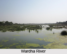 Geography of Yavatmal district is determined to a great extent by its location. The district of Yavatmal is situated in the eastern region of the state of Maharashtra. It is bounded by the Hingoli district and Washim district in the west and Amravati district and Wradha district in the north. To the east lies the Chandrapur district and to the south lie the district of Nanded and the state of Andhra Pradesh. The district consists of masses of hilly country broken by broad valleys and partially surrounded by plains. The southern half of Yavatmal taluka, which is just in the middle of the district, is a plateau with very steep sides. Here and there it rises into ridges or into flat-topped or pointed hills. Steep, rough ranges of hills occur to east and west right across the district. In the north, the district extends into the Payanghat valley of Berar. The Wardha valley, which marks the boundary of the district for over a hundred miles, continues this belt of plain across the north of Kelapur taluka and the northern and eastern sides of Wani taluka. The chief rivers are the Wardha River and the Penganga River both of which flow along the boundary of the district. Each has various tributaries, which traverse its centre. The Penganga River gives a strip of plain in many parts of its course along the southern border of the district. The tributaries of the Penganga again have formed valleys, often some miles in breadth, through the hilly country.
The climate of the district is in general hot and dry with moderately cold winters. The year may be divided into four seasons. The hot season begins in March and extends up to the first week of June. May is generally the hottest month of the year with the mean daily maximum temperature at about 42 degrees Celsius. This is followed by the south west monsoon season which lasts up till the end of September. With the onset of the south west monsoons there is an appreciable fall in temperatures and the weather becomes pleasant. October and November constitute the post monsoon season and is followed by the cold season which lasts up till February. From about the end of November both day and night temperature fall rapidly and December is usually the coldest month of the year with the mean daily minimum temperature at about 13 C. Most of the total annual rainfall is reserved during the south west monsoon season. The rainfall is not uniform in all parts of the district. Wani in the eastern part of the district receives 1,125 mm of rain and Darwha in the western, part of the district receives 889 mm of rain Yavatmal in the central portion of the district receives 1099.5 mm of rain. In general, the amount of rainfall increases as one proceeds from west to east. The average rainfall received by the district is around 964.7 mm. There is generally a breeze in the hot weather, so that the nights are cool. The cold waves over northern India sometimes affect the district and the minimum temperature may drop to about 5 degrees Celsius.
In Yavatmal district the Archaean rocks, which consist of crystalline rocks of various kinds, were entirely covered by Puranic rocks, which consists mainly of sediments. These were covered in turn by the Gondwana system, consisting of sub aerial and freshwater deposits. Next, the Deccan traps were spread over all. Finally the action of the atmosphere removed the Decan trap in parts, exposing, Gondwana and Lameta beds. During the last stage alluvial soil, the common black cotton soil was spread over parts of the district.
Purana rock is found at various places in the south. It consists of shales, slates, limestones, and sandstones. The shales are deep red, fine grained, with a somewhat nodular structure, much jointed, but irregularly breaking up into small, minute, angular fragments. Thin beds of limestone occur in them. Capital section of these rocks is seen in the Penganga and its tributaries. At Yenuk, south of the Wani taluka there is a hill formed of Purana sandstone. It contains several bands of conglomerates in which pebbles of hematite are found. Iron-ore used to be made from this hematite. Rocks belonging to the Gondwana system are also found in Wani taluka. They occupy its south eastern half. Like the Purana rocks they are often shales, slates, limestone, and sandstones. Unlike them, they often take the form of coal. There is a large coalfield in Wani taluka which extends under Wardha to Warora in Chandrapur district and under the Penganga into the Nizam`s Dominions. At Wanjra above five miles north of Wani town a small hill is composed of pinkish limestone of this bed. West of Wani the limestone continues varying in colour from buff to dark grey, and contains chert, passing into jasper in tolerably regular layers. To the west and north of Kayar there is deep angle in the trap and beds which are possibly Lameta. Deccan trap is spread over the greater part of the district. In the southern half it forms irregular hills, and some of these in Pusad taluka are nearly 2000 feet high.
Administration of Yavatmal District
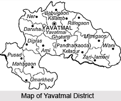
Yavatmal district has five sub divisions: Yavatmal, Darwah, Pusad, Kelapur and Wani. Besides this there are 16 Talukas and 16 Grampanchayat Samitis. There are a total of 2117 villages in this district. Out of these 1845 are inhabited.
Culture of Yavatmal District
Hinduism, Buddhism and Jainism are followed by the masses dwelling in Yavatmal District. Festivals, such as, Gudi Padwa, Diwali, Rangpanchami, Gukulasthami, are celebrated with lot of enthusiasm. Among all Ganesh Mahostav is the most important festival of Yavatmal people. Ghanti Baba fair at Digras and Shri Ranganath Swami Fair at Wani are most famous fairs.
Education of Yavatmal District
In Yavatmal town except various schools, the main colleges are Ayurvedic Colleges, Polytechnic Institutions, Yavatmal`s girls college, college for Physical training, College for Industrial training, medical colleges and Govt. B.Ed College.
Economy of Yavatmal District
Yavatmal town is the chief trading center of the district. Cotton grinning and pressing is the main occupation here. It is also called the cotton city. Major business establishment includes the Raymond factory, which produces the jeans fiber. It is 100% export unit from Raymond"s, which is a famous cloth brand.
The other local businesses in town are dominated by presence of agriculture supply facilities. Except Jowar and cotton the other crops are groundnut and pulses. The chief exports articles are cotton and teak wood. The other export items are cotton bales, lime, ice candy, wooden furniture, sugar, animal food items, oranges, Coal and Tendu leaves.
The small-scale industries are handlooms, Bidi rollings and hand made papers. The large scale industries are Ginning and pressing Mills, Sugar factories, spinning Mills, Cattle-feed made industries, Cement factories, Oil Mills and a Industrial estate, which is at Lahora near Yavatmal and at Wani and Pusad. Aluminum Utensils, synthetic Nylon fibers and other goods are manufactured at Lahora. Cement pipes, coolers and plastic goods are also made here.
Tribes of Yavatmal District
 Tribes of Yavatmal district are varied in type and number. Most of these tribes are involved in agricultural activities and constitute lie scattered all over the district. Most of these tribal groups have a language and culture of their own, though they are equally capable of communicating outside their specific groups. Some of the major tribal groups found in the district of Yavatmal are discussed below.
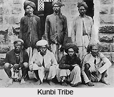
Kunbi tribe : The great cultivating castes of the Kunbis constitute 22 per cent of the population, though they are not as numerous in Yavatmal as in other districts of Berar. The Kunbi tribe makes up about a quarter of the population and they are representative of the agriculture class to which the bulk of patels and cultivators belong.
Andh : The Andhs are stated in the Census Reports as an aboriginal tribe. Nothing can be ascertained as to their origin, and they are not found in any Province. They have now adopted nearly all the practices of the Kunbis and are hardly distinguishable from them in dress or personal appearance. Like them, the Andh are also involved in cultivation. They employ a Brahmin as their priest, and profess to be Vaishnavas by religion, wearing the distinguishable marks of the sect on their foreheads.
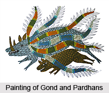
Gond and Pardhans : Like the Andhs, the Gond tribe and Pardhans have adopted Hindu dress and customs to a larger extent. The Pardhans are the bards and musicians of the Gonds. Together they constitute about 10 per cent of the population. The Gonds have three subdivisions-Raj-Gonds, Dadves, Mokasis. The name of the last may possibly be derived from the fact that they held a privileged tenure under the Chanda kings and they rank even higher than the Raj-Gonds, who will take the food at their hands. The Dadves take food from either of the other two. Besides these sub castes, which are endogamous, the Gonds are also divided into sections that worship a number of different gods. No two persons who have the same number of Gods are allowed to marry each other. The people of the tribe speak Gondi among themselves and are also conversant in communicating in the Marathi language. They are mostly tenants and labourers and a few are patels of villages.
Kolam : The Kolams are a Dravidian tribe akin to the Gonds but distinct from them. They reside principally in the Wun taluka. They have a language of their own. In some respects they retain very primitive customs, but in dress they can hardly be distinguished from Kunbis.
Banjara : The Banjaras are 6 per cent of the population, residing principally in the forest tracts to the south of the district. They are also known as Labhana as a result of their former occupation of carrying salt. The Mathuria sub-caste are the highest and wear the sacred thread. They generally live a reputable life. The women wear two little sticks fixed in their hair, over which their cloth is drawn. The front portion of the hair hangs down beside the face and the hair at the back is woven into a plait with a silk thread. They have large ornaments of silver tied over the head and hanging down beside the ears. To these are attached little bells. Their arms are covered with bangles of ivory, and they have tinkling anklets on the feet. The women wear skirts and short cloths drawn over the shoulders and along their skirts double lines of cowries are embroidered.
Mali : The Malis or Marals are four per cent of the population and are chiefly occupied in growing vegetables and garden crops. They have several local subdivisions such as the Kosaria, Phulmali, Bhange, Bawne, Jire, Harde, Ghase, and Pahad.
Thus discussed are the various tribes found existing in the district of Yavatmal in Maharashtra.
Tourism in Yavatmal District
Kalamb is an ancient village situated on Nagpur- Yavatmal road. There is a typical underground temple dedicated to Shri Chintamani.A famous a water tank as `Ganesh kunda`is available there. The village is situated in the riverbank of Chakravarti. The fair of Shri Chintamani is held in the month of December or Magh Shudha from Chaturthi to Saptami.
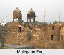
Wani is the tehsils head quarter, situated on the bank river of Nirguda. The famous temple of Shri Raghunath Swamy is situated in this place. Wani is an important center of trade in cattle and bullocks. There are coalmines near to Wani.
Datta Mandir and Khateswar Maharaj temples are famous in Jambhora. Hot water spring at Kapeswar on the bank of Peinganga river is a famous place. Jagat temple and Khojochi mosque are the important places in the Yavatmal town.
Transport of Yavatmal District
Nearest airport is Sone Gaon. Yavatmal is also interlinking with Mumbai, Delhi, Bengaluru and Nagpur. A 19- seated aircraft operating between Yavatmal and Mumbai can cater to the existing travel needs of the tourists.
Rail It is well connected with Mumbai- Nagpur Railway line.
Road It is well connected with all its neighbouring cities
Rail It is well connected with Mumbai- Nagpur Railway line.
Road It is well connected with all its neighbouring cities
Recently updated articles in States of India

History of Thissur District
Early History of Thissur District explains flourishing of the port cities. Now these port cities are transformed into archaeological sites.

Tippi Orchid Research Centre, Arunachal Pradesh
Tippi Orchid Research Centre in Arunachal Pradesh is renowned for its rich collection of exotic and endangered orchids. Surrounded by lush rainforest...

Tourism in Nashik District
Pilgrimage tourism in Nashik district involves visiting the various places of Hindu and Jain worship located here. Some of the holiest sites for Hind...

Mangadu, Kerala
Mangadu in Kerala’s Kollam district is a significant megalithic site known for its urn burials, cist burials, menhirs, and stone circles. Excavations...

Devaswom
History of Devaswom is not very ancient and can be dated back to late seventeenth century.
Related articles in States of India

East Indian States
East Indian States comprises of Bihar, Jharkhand, West Bengal, Odisha and also the Union Territory of Andaman and Nicobar Islands. It defines the cult...

Purnia District in Bihar
Purnia District is located in Bihar and extends from River Ganga to Nepal. The district has a rich Hindu history and glorious past.

Hooghly district
Hooghly District along the bank of the river Hooghly is one of the principal trading ports of West Bengal.

Geography Of Chittoor District
Geography of Chittoor district is spread along the topography of the land which is divided into two natural divisions; Chittoor has a dry and healthy...

Districts of West Bihar
Districts of West Bihar is comprised of medieval monuments that were built by the different governors of Mughal era.