 Tikamgarh district is situated in the northern parts of the state of Madhya Pradesh in India. The district has got its name from the headquarters town as Tihri, in Orchha. In the year 1783, Raja Vikramajit shifted his capital from Orchha town to Tihri and renamed it Tikamgarh but it was officially recognised in the year 1887. The name was adopted in the honour of Lord Krishna, Tikam being one of his appellations. The district enjoys a monsoon type climate throughout the year and the average rainfall of the district is forty inches. This district is a famous tourist destination in the state of Madhya Pradesh which attract people from various parts of the state as well as from several other corners of India and also from outside. According to the 2001 census, the total population of the district is 12, 02,998.
Tikamgarh District
Tikamgarh district is located in the northern region of Madhya Pradesh in India. The district of Tikamgarh is having several temples which form the major attraction of the district.
Introduction
Tikamgarh district is situated in the northern parts of the state of Madhya Pradesh in India. The district has got its name from the headquarters town as Tihri, in Orchha. In the year 1783, Raja Vikramajit shifted his capital from Orchha town to Tihri and renamed it Tikamgarh but it was officially recognised in the year 1887. The name was adopted in the honour of Lord Krishna, Tikam being one of his appellations. The district enjoys a monsoon type climate throughout the year and the average rainfall of the district is forty inches. This district is a famous tourist destination in the state of Madhya Pradesh which attract people from various parts of the state as well as from several other corners of India and also from outside. According to the 2001 census, the total population of the district is 12, 02,998.History of Tikamgarh district
scattered at a number of places including Garh Kudar, Prithvipur, Mohangarg, Orchha, Lidhoura, Digora, Barana, Baldeogarh and Tikamgarh town. The remnants suggest that the district had a rich and glorious past. The district of Tikamgarh previously used to be a part of the vast empires successively ruled by the Mauryas, the Sungas and the imperial Guptas. It was during the first quarter of ninth century A.D. that Mannuka founded a new dynasty; the Chandella dynasty in this area. Tikamgarh along with Khajuraho and Mahoba formed part of extensive Chandella Kingdom.
The Tikamgarh district was also held by the Khangras, especially around Garh Kundar and the rise in power of the Bundelas in this region led to the downfall of the Khangras. The Orchha records give an account of the descent of the Bundela Kingdom of Orchha from Garh Kudar chiefs of Benaras Hemkaran, also called Pancham Bundela.
The present district of Tikamgarh is situated in the northern parts of the state of Madhya Pradesh in India. The Tikamgarh district takes its name from the headquarters town as Tihri, in Orchha state. In the year 1783, Raja Vikramajit moved his capital from Orchha town to Tihri and renamed it as Tikamgarh; however it was officially recognised in the year 1887. The name of this district is also said to be adapted in the hour of Lord Krishna; `Tikam` being one of the appellations of the Lord. This district forms the north-western parts of Sagar District and it lies on the Bundelkhand Plateau between the Jamni, a tributary of Betwa River and Dhasan River.
Geography of Tikamgarh District
 Geography of Tikamgarh district is vast with an area of five thousand forty eight square kilometers. This district is situated in the northern portion of Madhya Pradesh. The district of Tikamgarh forms the north-western portion of the Sagar district. It is located on the Bundelkhand Plateau between the Jamni River, a tributary of Dhasan River and Betwa River. The district of Tikamgarh is situated in between twenty four degree twenty six minutes and twenty five degree thirty four minutes to the North Latitudes and between seventy eight degree twenty six minutes and seventy nine degree twenty one minutes to the East Longitudes.
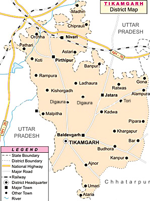
The shape of the Tikamgarh district is triangular with a very irregular northern margin. The maximum length of this district is about one hundred and nineteen kilometers from North to South and the width is about eighty kilometers. The district of Tikamgarh is bounded by the district of Chhatarpur to the east, Lalitpur district of Uttar Pradesh to the West, Jhansi district to the North and the district of Sagar to the South. The Eastern and Western boundaries are formed by two big rivers.
The climate of this district is monsoon type. The year may be divided into four seasons with winter season starting from the month of December till February followed by the summer season from the month of March to about the middle of June. The period from about mid-June to the end of September forms the rainy season. October and November form the post-monsoon or transition season. There is a single rain gauge station in the Tikamgarh district. The average rainfall of the district is forty inches. It varies from thirty three inches to fifty four inches in different parts of the district. Generally rainfall in the district increases from northwest to southwest. Some parts of the Niwari tehsil and Mohangarh of Jatara tehsil also come in the low rainfall zone. About ninety percent of the annual rainfall in this district of the Madhya Pradesh state is received during the south-west monsoon season which is from June to September. The month of July is the rainiest month.
The temperature in the district of Tikamgarh rises progressively after the month of February. The month of May is usually the hottest month with mean daily maximum temperature at about forty three degree Celsius and the low temperature being twenty nine degree Celsius. Temperature even rises to forty seven degree Celsius on some days. The district experiences a high relative humidity during the monsoon season, which is generally above seventy percent, while in the rest of the year the air is comparatively dry. The driest part of the year in this district is during the summer season when the relative humidity is less than twenty percent in the afternoons. Agriculture and related pursuits have always been the predominant occupation of the mainly rural area which, though not among the most fertile, has enough to reward well the tradition bound and hard working farming community of the district. The geographical environment of this district makes possible the cultivation of crops like jowar, urad, wheat, paddy, etc.
Administration of Tikamgarh district
The district administration of Tikamgarh is under the control of the district collector. The collector is the head of the district and he or she is assisted by his subordinate officers in his general work of administration. The district of Tikamgarh is divided into six tehsils grouped into three sub divisions of Tikamgarh, Niwari and Jatara. The Tikamgarh sub division possesses Tikamgarh and Baldeogarh tehsils, Niwari and Prithvipur tehsil form Niwari Sub Division whereas the Jatara sub division possesses Jatara and Palera Tehsil. There are six development blocks called Tikamgarh, Baldeogarh, Jatara, Palera, Niwari and Prithvipur.
Education in Tikamgarh district
Public instruction in an organised manner came into existence only in the nineteenth century. In the year 1812, a treaty was signed between the British and the then King of Orchha. This was followed by the introduction of Lord Macaulay`s system in the year 1835. However, the first school was founded only in the year 1866, which remained the only educational institution in the state till 1877. In the beginning of the Century the literacy rate was 1.28 percent. In the year 1951 literacy rate has gone up to 3.57 percent. During the Census 1961, the district returned 9.67 percent. In the year 1971, the literacy rate has improved to 14.04 percent. In 1981 the literacy rate moved to 19.16 percent.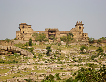 In the 1991 Census the literacy rate was 34.78 percent. In the 2001 Census the literacy rate was 55.80 percent. There has been substantial progress in the number of educational institutions in the district of Tikamgarh. There are about six Degree Colleges or Post Graduate Colleges in this district imparting instructions in Arts, Science and Commerce. There are also Professional and Technical Schools and Colleges. Various schools are also present in the Tikamgarh district.
In the 1991 Census the literacy rate was 34.78 percent. In the 2001 Census the literacy rate was 55.80 percent. There has been substantial progress in the number of educational institutions in the district of Tikamgarh. There are about six Degree Colleges or Post Graduate Colleges in this district imparting instructions in Arts, Science and Commerce. There are also Professional and Technical Schools and Colleges. Various schools are also present in the Tikamgarh district.Economy of Tikamgarh district
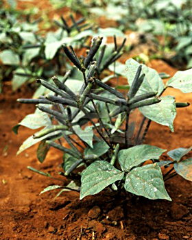
Agriculture and related pursuits have always been the predominant occupation of the mainly rural area which, though not among the most fertile, has enough to reward well the tradition bound and hard working farming community of the district. Thus, agriculture is the major contributor to the economy of the district of Tikamgarh. The main crops of the district are Jowar, Paddy, Wheat, Urad and Till, Soyabean amongst the oilseeds while sugarcane also is grown to a certain extent. Both the Kharif and Rabi crops are grown in the district. Besides Gram, Urad and Moong are among other important pulses of the district and are grown generally in Kharif. The oilseed crops grown in the district may be mentioned as rape and mustered, groundnut and linseed while Soyabean cultivation gained much popularity.
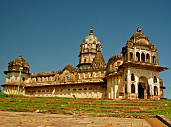
Temples in Tikamgarh District
 Temples in Tikamgarh district form the major attractions which draw a large number of pilgrims as well as general tourists from various parts of the state. One of the most famous places of pilgrimage in the district of Tikamgarh is the Ahar village. This village belongs to the Baldeogarh tehsil and it is situated on the side of Tikamgarh-Chhattarpur road at a distance of twenty five kilometers from the headquarters of the district. Ahar is an old village which is believed to have been populated by Jamalpur Ahars, which was once an important Jain Centre. Various ruins including old images and temples are located in this village. There are three old Jain temples of which one holds an image of Shantinath which is twenty feet in height. There is also a tank of the Chandella days with a fine dam.
Another place of pilgrimage in the Tikamgarh district is a village which is located about three kilometers to the West of Madia Village on Tikamgarh-Niwari road in the Prithvipur tehsil. This village stands on a hill. A famous temple of the Goddess of Achroo Mata is there in the village. It is reputed for a kund which is always filled with water and never dried despite a number of users. Every year, on the occasion of Nav-Durga festival which falls in the month of March-April (Chaitra), fair is organised under the supervision of Gram Panchyat.
 The headquarters town of the Baldeogarh is a tehsil of the same name. It is located on the Tikamgarh-Chhattarpur road at distance of twenty six kilometers from Tikamgarh. The massive rock fort standing above the beautiful tank Gwal-Sagar, presents a very pleasing sight. The fort is a very fine specimen of its class and one of the most picturesque in the region. A big old Gun is still placed in this fort. The importance of this town also lies in its famous temple of `Vindhya Vasini Devi`. An annual, seven days Vindhyavasani fair is held here in the month of Chaitra.
Kudar is one of the famous village of Niwari tehsil located at a distance of twenty two kilometers on the Niwari-Senderi road. On the top of a small hill stands a fort constructed by Maharaja Birsingh Dev. The temple of local Goddess Maha Maya Gridh Vasni stands here. There is also a large tank held on the temple Goddess, which is called `Singh Sagar`. Another place of religious importance is Kundeshwar. It is located five kilometers to the south of Tikamgarh town on the bank of the Jamdar River. This place is known for Kundadev Mahadev temple. It is believed that Shiv Linga has emerged from Kunda. In the south of it there is very fine picnic spot known as `Barighar` and a beautiful waterfall known as `Usha Water Fall`. The village holds an Archeological Museum and Vinobha Sansthan. Maharaja Birsingh Deo founded the Keshva Sahitya Sansthan which was patronised by Pandit Banarsidas Chaturvedi and Yaspal Jain during their stay at Kundeshwar.
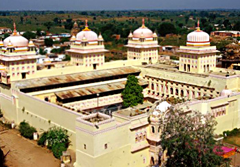
The famous Sun temple is located in the Madkhera village. The entrance to the temple is from the east. The idol of Sun God is placed here inside the temple. The other main object of interest of the village is a temple of Vindhya Vasani Devi on the top of hill. Niwari is the headquarter town of the Niwari tehsil of the same name. It is located on the Tikamgarh-Jhansi road, at a distance of about eighty kilometers to north-west of Tikamgarh. It holds a temple of Khedapati Hanumanji. One of the most famous places of religious importance for the Hindus is Orchha. It is known for its cultural and religious heritage. There are several places of pilgrimage which include the Ram Raja Temple, Chaturbuj Temple, Laxmi Temple, Chandra Shekhar Azad Memorial, Badi Chhatrian, Savan- Bhadon, Hardol Ki Samadhi, Rai Praveen Mahal, Keshav Bhavan, Jahagir Mahal, Phool Bagshish Mahal, Kanchana Ghat, etc.
The village of Papora in the district of Tikamgarh holds about eighty Jain temples. The famous Jain temples of twenty four Tirthakars are the most prominent attractions of this place. An important Jain fair is held in the month of Kartika sudi Purnima which attracts a large number of pilgrims. The Somnath temple, Atan ke Hanumanji and the Ramjanki temple are some of the most famous temples located at Prithvipur in the Tikamgarh district.
Recently updated articles in States of India

History of Thissur District
Early History of Thissur District explains flourishing of the port cities. Now these port cities are transformed into archaeological sites.

Tippi Orchid Research Centre, Arunachal Pradesh
Tippi Orchid Research Centre in Arunachal Pradesh is renowned for its rich collection of exotic and endangered orchids. Surrounded by lush rainforest...

Tourism in Nashik District
Pilgrimage tourism in Nashik district involves visiting the various places of Hindu and Jain worship located here. Some of the holiest sites for Hind...

Mangadu, Kerala
Mangadu in Kerala’s Kollam district is a significant megalithic site known for its urn burials, cist burials, menhirs, and stone circles. Excavations...

Devaswom
History of Devaswom is not very ancient and can be dated back to late seventeenth century.
Related articles in States of India

East Indian States
East Indian States comprises of Bihar, Jharkhand, West Bengal, Odisha and also the Union Territory of Andaman and Nicobar Islands. It defines the cult...

Purnia District in Bihar
Purnia District is located in Bihar and extends from River Ganga to Nepal. The district has a rich Hindu history and glorious past.

Hooghly district
Hooghly District along the bank of the river Hooghly is one of the principal trading ports of West Bengal.

Geography Of Chittoor District
Geography of Chittoor district is spread along the topography of the land which is divided into two natural divisions; Chittoor has a dry and healthy...

Districts of West Bihar
Districts of West Bihar is comprised of medieval monuments that were built by the different governors of Mughal era.