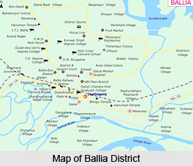
Geography of Ballia District is spread over level plain, intersected by numerous streams. Though there are no hills, the level surface is varied because of the high banks of the major rivers. There are depressions of varying depth and extent in which the drainage water collects, prior to its draining into the main systems of the river. Geographically, Ballia District is divided into two natural divisions - the interior upland and the lowland tract. The upland has an average altitude of 64 metres above sea-level and comprises the western half of the district, including the whole of the Bhadaon, Lakhnesar and Kopachit Parganas and a narrow strip of land extending eastwards into the Kharid and Ballia Parganas.
The soil is for the most part a light loam with a fair mixture of sand. The proportion of sand increases on the higher ridges and the soil becomes very light, though not unfertile. In the depressions the soil is mostly clayey and in these tracts paddy is the chief crop. The lowland tract comprises the rest of Ballia District but is far from being of a uniform character. The surface of the lowland is usually very uneven. The level is about 4.5 meters below that of the upland, though it varies from place to place.
The climate of Ballia District is moist and relaxing except in the summer and cold seasons. The year may be divided into four seasons - winter season (which lasts from about the latter half of November to February) summer season (from March to mid June), south-west monsoon season (which constitutes the period from about the mid of June to the end of September) and the post-monsoon or transitional season (which covers October and the first half of November). Records of rainfall in the district are available for four stations for fairly long periods. The average annual rainfall in the district is 1,013.1 mm. About 88 per cent of the annual rainfall is received during the south-west monsoon months (June to September), August being the rainiest month.
The relative humidity is generally high during the south-west monsoon season, being 70 per cent. Winds are generally light with some increase in force during the latter part of the summer and early part of the monsoon season. Some of the monsoon depressions from the Bay of Bengal move in a westerly to north-westerly direction and affect the weather of district causing widespread heavy rain and gusty winds. Dust storms and thunderstorms occur during the summer season. Rain in the monsoon season is often associated with thunder.
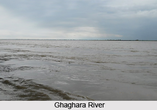
Geography of Ballia District includes three main rivers in the district - Ghaghara River, Ganga River and the Saryu River. Ghaghara River flows through the northern border of the district. It receives very little drainage in this district and so its tributaries are insignificant. Ganga first touches the boundary of the district in the extreme south. In the district, River Ganga flows in a north-easterly direction as far as the town of Ballia and from there it turns towards the south-east and after flowing for some distance it turns north-east. The chief tributary of Ganga in this district is the Saryu.
Topography of Ballia District includes several lakes. The most important lake in the district is the great Suraha Tal which covers a large area. Among other lakes the largest is the Mundiari Dah. Others are Taliji Tal, Kawal Dah, Goka Tal and Reoti Dah.
The geology of Ballia District exposes nothing except the ordinary Gangetic alluvium. The mineral products are few being confined to the saline earth from which saltpeter and salt are produced. Ballia District is situated in the area where earthquakes of slight to moderate intensity have been experienced in the past. Further, there are no forests in the district but along the great rivers there are numerous expanses of sandy ground covered with jhau or tamarisk which afford cover to wide pig and other animals. Thus, the variety and number of wild animals is limited.