Districts of Manipur
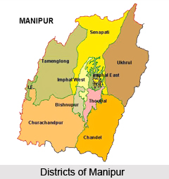
Districts of Manipur include nine administrative districts. These districts are headed by districts magistrates.

Share this Article:

Introduction

Districts of ManipurDistricts of Manipur hold the history and culture of India. The state of Manipur is popular for Manipur classical dance and is also the founder of polo in India. The name Manipur literally meaning `A jewelled land` nestled deep within a lush green corner of North East India. Surrounded by blue hills with an oval shaped valley at the centre this state of north east India is rich in art and tradition. This is the place where Rajashree Bhagyachandra created the famous Ras Lila, the classical dance of Manipur. The folk dances of Manipur reveal the mythological concept of creation of this region.

Manipur came under the British Rule as a Princely State after the defeat in the Anglo-Manipuri War of 1891. After the independence of country, this state was merged in the Indian Union on October 15, 1949 and it became a full-fledged state of India on 21st January, 1972. The State is represented in the Lok Sabha by two members and by one member in the Rajya Sabha.

There are nine administrative districts of Manipur and these are -
* Bishnupur
* Churachandpur
* Chandel
* Imphal East
* Imphal West
* Senapati
* Tamenglong
* Thoubal
* Ukhrul


Districts of South Manipur Division

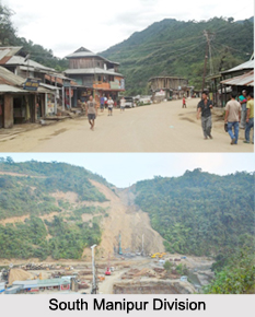
Districts of South Manipur DivisionDistricts of South Manipur Division include the Jiribam District, Noney District, Pherzawl District, Churachandpur District, Chandel district and Tengnoupal District.

Jiribam District : Jiribam District is a new district in the Indian state of Manipur, created by bifurcating erstwhile Imphal East district.

Noney District : Noney District is a new district in Manipur, India, created by bifurcating erstwhile Tamenglong district. Longmai administers Noney District. It is a town located 63 km away from Imphal the capital of Manipur. Longmai is a large village located in Nungba of Tamenglong district, but recently Longmai has officially declared as one of the New District Head Quarter of Manipur separated from existing Tamenglong District now constituted by Haochong, Khoupum,Nungba and Longmai Sub-division, with the coming of the land demarcation some upgradation may take place. Zeliangrong Community mostly with Rongmei Tribe with the total 635 families inhabits Longmai town. The Longmai village has population of 3854 of which 2140 are males while 1714 are females as per Population Census 2011.

Pherzawl District : Pherzawl District is located in the southern part of the state of Manipur. It is bounded on the east by Churachandpur District; on the north by Tamenglong District; on the west by the Cachar District of Assam and on the South by Sinlung Hills, Mizoram. Pherzawl District is located between 93 degree 11 minutes and 16 degree 44 minutes East Longitude and 24 degree 15` minutes 43 degree 524 minutes North Latitude and is in the southern part of Manipur state. Pherzawl District has approximately 200 villages, according to the government`s record.

Churachandpur District : Churachandpur is a district located in the southwestern corner of the Indian state of Manipur which covers an area of 4,750 kilometres. According to the population Census in the year 2011, Churachandpur district had a population of 271,274. This gives it a ranking of 575th in India. The district has a population density of 59 inhabitants per square kilometers. Its population growth rate over the decade 2001–2011 was 19.03%. Churachandpur District has a sex ratio of 969 females for every 1000 males, and a literacy rate of 84.29%.

Chandel District: Chandel District of Manipur has its administrative headquarters located at Chandel. Moreh is an important town of this district of Manipur that is also a significant trade hub between Manipur and Myanmar.

Tengnoupal District : Tengnoupal District is a new district in Manipur created by splitting the Chandel district.


Districts of Inner Manipur Division

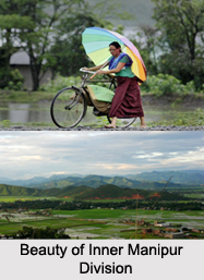
Districts of Inner Manipur DivisionDistricts of Inner Manipur Division include districts like Bishnupur district, Imphal West district, Imphal East district, Thoubal district and Kakching District. These districts in medieval era are the abode of Ahom Dynasty.

Bishnupur District: Bishnupur district is the smallest administrative district of Manipur. The name of this district is derived from a Vishnu Temple that is situated at Lamangdong. Major towns of Bishnupur District are Bishnupur, Nambol, Moirang, and Kumbi.

Imphal West District : Imphal West district is one of the nine districts of Manipur. As of 2011, Imphal West district is the most populous district in the state. Lamphelpat is the district headquarters of Imphal West district in the state of Manipur. It is a suburb of Imphal city.

Imphal East District : Imphal East district is one of the 9 districts of Manipur state in northeastern India. As of 2011, Imphal East district is the second most populous district in the state, after Imphal West. Agriculture is the main occupation of the people in Imphal East district. In the district, there are 27,000 and 4,100 hectares of land for high yield variety and improved local paddy field respectively. There are land of 450 hectares for maize, 60 hectares for wheat and 350 hectares for potato in the Imphal East district.

Thoubal District : Thoubal district is one of the nine districts of Manipur state in northeastern India. Senapati district on the north, Ukhrul and Chandel districts on the east, Churchandpur and Bishnupur districts bound this district on the south and Imphal West and Imphal East districts on the west. The district occupies an area of 519 square km. The population as of 2011 is 422,168. Thoubal town is the district headquarters. Thoubal district is known for Khongjom, where the last battle of the independence of Manipur was fought in April 1891 against the army of British Government in India. The Imphal and the Thoubal are the most significant rivers that flow through the district. The Thoubal River originates in the hill ranges of Ukhrul and is an important tributary of the Imphal River. It passes through Yairipok and Thoubal before joining the Imphal at Irong near Mayang Imphal. The Imphal River rises in the hills of Senapati district and flows south. It forms the northern and western boundaries of Thoubal district. There are other rivers in Thoubal district namely the Wangjing, the Arong and the Sekmai. These rivers originate in the hills of Ukhrul district. The Arong River flows through Khangabok and falls into Kharung Pat. The Wangjing River flows west via Heirok and Wangjing before joining the Loushi Pat.

Kakching District : Kakching District is one of the 16 districts of Manipur state. Kakching District is bounded by Thoubal district on the north, Ukhrul District and Chandel District on the east, Churchandpur District and Bishnupur district on the south and Imphal West District and Imphal East district on the west. The Kakching district is one of the newly formed districts by the government of Manipur in 2016.

Other Districts of Maniour

Senapati District : Senapati District is an administrative district of Manipur. It is surrounded by Imphal District in its south, by Ukhrul District in its east, by Tamenglong District in its west and by Nagaland in its north.

Tamenglong District:
Tamenglong District of Manipur has its administrative headquarters at Tamenglong Town. It is surrounded by Nagaland in its north, by Senapati District of Manipur in its north and east, by Churachandpur District in its south and by Imphal West District and Assam
Ukhrul District: Ukhrul District of Manipur is situated at about 84 km to the east of Imphal. Ukhrul District is considered as the land of Tangkhul Tribe


Share this Article:

Related Articles

More Articles in States of India


East Indian States
East Indian States comprises of Bihar, Jharkhand, West Bengal, Odisha and also the Union Territory of Andaman and Nicobar Islands. It defines the cultural heritage, rich historical background and the linguistic unity.
Erode District
Erode District is one of the districts in the state of Tamil Nadu. The district of Erode is having a land-locked area with no sea coast.
Purnia District in Bihar
Purnia District is located in Bihar and extends from River Ganga to Nepal. The district has a rich Hindu history and glorious past.
South Delhi District
South Delhi District is the third largest district of Delhi as far as its area is concerned. South Delhi District is known for its economic, historical, cultural and social significance.
North Indian States
North Indian States formed the cultural and religious unity in spite of having many foreign invasion and the political disturbances from the early era till the British gained supremacy in Indian sub continent.
Kendujhar District
Kendujhar District, spread over an area of 8,240 sq kms, is as varied as the whole of Orissa with waterfalls roaring gorges, mountains and minerals. The manifold expressions of nature in Kendujhar District are considered as unique.
Hooghly district
Hooghly District along the bank of the river Hooghly is one of the principal trading ports of West Bengal.
Districts of South Tamil Nadu
Districts of South Tamil Nadu consist of many tourism destinations like archaeological sites and the history of Pandyas and Cholas. Considering their proximity to the sea, many districts also boast of serene beaches and coastal beauty.
Flora of Arunachal Pradesh
Flora of Arunachal Pradesh includes infinite species and is a subject of great interests for the botanists.
Districts of South Gujarat
Districts of South Gujarat are the epicenter of Jain pilgrimages and the early Hindu kingdoms.
North West States of India
North West States of India consist of three states, which are Rajasthan, Punjab and Haryana. All of them are culturally and traditionally diverse and they have been ruled by different dynasties in historical time.
Geography Of Chittoor District
Geography of Chittoor district is spread along the topography of the land which is divided into two natural divisions; Chittoor has a dry and healthy climate.
Districts of North Rajasthan
District of Northern part of Rajasthan is dotted with ancient forts and medieval villages.
Districts of North Odisha
District of North Odisha has Bengal boundary and shares the same culture. These are reachable if one pays a weekend visit to Digha.
Districts of West Bihar
Districts of West Bihar is comprised of medieval monuments that were built by the different governors of Mughal era.
Districts of South Haryana
Districts of South Haryana consists of many cities of industrial excellence. These districts are dotted with popular tourism destinations.
Medieval History of Assam
Medieval history of Assam narrates the advent and rule of a number of kingdoms in the region. The prominent dynasties of the kingdom left an everlasting imprint on the socio cultural heritage of India.
Geography of Meghalaya
The suitable climate, highland plateaus, rivers and the flora and fauna together forms the geography of Meghalaya.
Districts of Rayalaseema
Districts of Rayalaseema in Andhra Pradesh state has urban population and rural settlements as well.
Districts of South Punjab
Districts of Southern part of Punjab depict medieval history of Punjab and the rise of Sikhs.