Home > Travel > States of India > Districts in Shahdol Division
Districts in Shahdol Division
Districts in Shahdol Division include ancient and medieval towns, where the presence of temples, mosques and the forts made these districts historically important.

Share this Article:

Districts in Shahdol Division, Madhya PradeshDistricts in Shahdol Division in Madhya Pradesh include Shahdol District, Umaria District and Anuppur District.
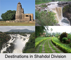
Shahdol District
Shahdol District is a district of Madhya Pradesh. Shahdol District has total area of 5,671 square kilometers and a population of 908,148. Shahdol District is an important district of Madhya Pradesh. The town of Shahdol is the district headquarters. The district is also a division. Some of the districts in this division are Annupur and Umaria. The Virateshwar Temple in Sohagpur Vangana is the most important tourist destination of Shahdol and a structural masterpiece. The district extends 110 km from east to west and 170 km from north to south.

Umaria District
Umaria District is an important north eastern district in Shahdol division of Madhya Pradesh state, having a global location between north latitude 23 degree 38 minutes to 24 degree 20 minutes and east longitude 80 degree and 28 minutes to 82 degree 12 minutes. The town of Umaria is the district headquarters. The district is part of Shahdol Division. The total geographical area of Umaria District sums up to 4548 square kilometers and has a population of 515,963. Umaria District is enriched with its vast resources of forests and minerals. The coalmines of Umaria District are a steady source of revenue for the district. The most important mineral found in the district is coal and as a result 8 mines are being operated by South Eastern Coalfields Limited in the district. The famous Bandhavgarh National Park (Tala) and Sanjay Gandhi Thermal Power Station at Mangthar (Pali) are located in the district. Umaria District was formerly the headquarters of the South Rewa District and thereafter the headquarters town of the Bandhavgarh tehsil. It is situated at a distance of about 69 km. from Shahdol, the parent district. Metalled roads connect the town with Katni, Rewa Shahdol, etc., on which regular buses ply. Umaria is also a railway station on the Katni-Bilaspur section of the South-Eastern Railway.

Anuppur District
Anuppur District is an administrative district in Shahdol Division of Madhya Pradesh state in central India. Anuppur District is bordered by Korea District of Chhattisgarh state on the east, Bilaspur District of Chhattisgarh on the southeast, Dindori District of Madhya Pradesh on the southwest, Umaria District of Madhya Pradesh on the west, and Shahdol District on the northwest and north. The administrative headquarters of the district is Anuppur. The district has one Jawahar Navodaya Vidyalaya at Amarkantak which is the origin of two rivers i.e. Narmada River and Son River. Anuppur District was created on 15th August 2003 out of Shahdol District. It is part of Shahdol Division.


Share this Article:

Related Articles

More Articles in States of India


East Indian States
East Indian States comprises of Bihar, Jharkhand, West Bengal, Odisha and also the Union Territory of Andaman and Nicobar Islands. It defines the cultural heritage, rich historical background and the linguistic unity.
Erode District
Erode District is one of the districts in the state of Tamil Nadu. The district of Erode is having a land-locked area with no sea coast.
Purnia District in Bihar
Purnia District is located in Bihar and extends from River Ganga to Nepal. The district has a rich Hindu history and glorious past.
South Delhi District
South Delhi District is the third largest district of Delhi as far as its area is concerned. South Delhi District is known for its economic, historical, cultural and social significance.
North Indian States
North Indian States formed the cultural and religious unity in spite of having many foreign invasion and the political disturbances from the early era till the British gained supremacy in Indian sub continent.
Kendujhar District
Kendujhar District, spread over an area of 8,240 sq kms, is as varied as the whole of Orissa with waterfalls roaring gorges, mountains and minerals. The manifold expressions of nature in Kendujhar District are considered as unique.
Hooghly district
Hooghly District along the bank of the river Hooghly is one of the principal trading ports of West Bengal.
Districts of South Tamil Nadu
Districts of South Tamil Nadu consist of many tourism destinations like archaeological sites and the history of Pandyas and Cholas. Considering their proximity to the sea, many districts also boast of serene beaches and coastal beauty.
Flora of Arunachal Pradesh
Flora of Arunachal Pradesh includes infinite species and is a subject of great interests for the botanists.
Districts of South Gujarat
Districts of South Gujarat are the epicenter of Jain pilgrimages and the early Hindu kingdoms.
North West States of India
North West States of India consist of three states, which are Rajasthan, Punjab and Haryana. All of them are culturally and traditionally diverse and they have been ruled by different dynasties in historical time.
Geography Of Chittoor District
Geography of Chittoor district is spread along the topography of the land which is divided into two natural divisions; Chittoor has a dry and healthy climate.
Districts of North Rajasthan
District of Northern part of Rajasthan is dotted with ancient forts and medieval villages.
Districts of North Odisha
District of North Odisha has Bengal boundary and shares the same culture. These are reachable if one pays a weekend visit to Digha.
Districts of West Bihar
Districts of West Bihar is comprised of medieval monuments that were built by the different governors of Mughal era.
Districts of South Haryana
Districts of South Haryana consists of many cities of industrial excellence. These districts are dotted with popular tourism destinations.
Medieval History of Assam
Medieval history of Assam narrates the advent and rule of a number of kingdoms in the region. The prominent dynasties of the kingdom left an everlasting imprint on the socio cultural heritage of India.
Geography of Meghalaya
The suitable climate, highland plateaus, rivers and the flora and fauna together forms the geography of Meghalaya.
Districts of Rayalaseema
Districts of Rayalaseema in Andhra Pradesh state has urban population and rural settlements as well.
Districts of South Punjab
Districts of Southern part of Punjab depict medieval history of Punjab and the rise of Sikhs.