Home > Travel > States of India > Dirang
Dirang
Dirang village is located in the West Kameng District of Arunachal Pradesh. It is an overnight destination for tourists travelling to Tawang. It is popular for it gompas, Dirang Fort and National Yak Research Center.

Share this Article:

Dirang, Kameng District, Arunachal PradeshDirang village is located in the West Kameng District of Arunachal Pradesh state. It is located at an altitude of 1497 meters and 47 km away from Bomdila. Dirang is popular among tourists for its gompas and colourful Kalchakra celebrations. It is an overnight destination for tourists travelling to Tawang. Dirang, located on the banks of Kameng River, has pleasant weather throughout the year.

Tourism in Dirang
Along with the scenic spots, monasteries and Kalchakra celebrations, there are several other tourist spots in Dirang. Some of the tourist spots are National Yak Research and Breeding Centers, Sheep Breeding Farm, Dirang Dzong (Fort), Hot Water Spring, Sangti Valley etc. Some of these places have been detailed below in brief.

Dirang Dzong: The Dirang Dzong or Dirang Fort has got some Bhutanese influence for being located close to Bhutan. The fort is about 150 years old and some surrounding stone houses of it are considered to be 500 years old. There is a stone staircase on the entrance of the fort. It gives an excellent view of its surrounding.

Hot Water Spring: There is a holy hot water spring located at a distance of 1 km from Dirang on the way to Tawang. The spring water is rich in sulphur and other medicinal properties. People can take bath in this hot water spring as well.

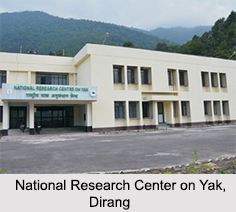
National Yak Research and Breeding Centers: This center researches on genetic resources and problems associated with the production of Yak. It also conducts researches on the improvement of Yak and its products through the selection and breeding process with frozen semen. The center can be visited by tourists with permission. It has also a Yak farm at Nyukmandung, which is about 31 km from Dirang.

Nearby Places around Dirang
Some of the nearby places of Dirang are Tawang (138 km), Bomdila (47 km), Bhalukpong (144 km), Tezpur (200 km) and Sela Pass (80 km/ at an altitude of 13,700 feet).

Visiting Information on Dirang
Asan Railway Station (70.9 km) and Lokpriya Gopinath Bordoloi International Airport at Guwahati (351 km) are the nearest to Dirang. National Highway 27 connects Dirang to other parts of India.


Share this Article:

Related Articles

More Articles in States of India


East Indian States
East Indian States comprises of Bihar, Jharkhand, West Bengal, Odisha and also the Union Territory of Andaman and Nicobar Islands. It defines the cultural heritage, rich historical background and the linguistic unity.
Erode District
Erode District is one of the districts in the state of Tamil Nadu. The district of Erode is having a land-locked area with no sea coast.
Purnia District in Bihar
Purnia District is located in Bihar and extends from River Ganga to Nepal. The district has a rich Hindu history and glorious past.
South Delhi District
South Delhi District is the third largest district of Delhi as far as its area is concerned. South Delhi District is known for its economic, historical, cultural and social significance.
North Indian States
North Indian States formed the cultural and religious unity in spite of having many foreign invasion and the political disturbances from the early era till the British gained supremacy in Indian sub continent.
Kendujhar District
Kendujhar District, spread over an area of 8,240 sq kms, is as varied as the whole of Orissa with waterfalls roaring gorges, mountains and minerals. The manifold expressions of nature in Kendujhar District are considered as unique.
Hooghly district
Hooghly District along the bank of the river Hooghly is one of the principal trading ports of West Bengal.
Districts of South Tamil Nadu
Districts of South Tamil Nadu consist of many tourism destinations like archaeological sites and the history of Pandyas and Cholas. Considering their proximity to the sea, many districts also boast of serene beaches and coastal beauty.
Flora of Arunachal Pradesh
Flora of Arunachal Pradesh includes infinite species and is a subject of great interests for the botanists.
Districts of South Gujarat
Districts of South Gujarat are the epicenter of Jain pilgrimages and the early Hindu kingdoms.
North West States of India
North West States of India consist of three states, which are Rajasthan, Punjab and Haryana. All of them are culturally and traditionally diverse and they have been ruled by different dynasties in historical time.
Geography Of Chittoor District
Geography of Chittoor district is spread along the topography of the land which is divided into two natural divisions; Chittoor has a dry and healthy climate.
Districts of North Rajasthan
District of Northern part of Rajasthan is dotted with ancient forts and medieval villages.
Districts of North Odisha
District of North Odisha has Bengal boundary and shares the same culture. These are reachable if one pays a weekend visit to Digha.
Districts of West Bihar
Districts of West Bihar is comprised of medieval monuments that were built by the different governors of Mughal era.
Districts of South Haryana
Districts of South Haryana consists of many cities of industrial excellence. These districts are dotted with popular tourism destinations.
Medieval History of Assam
Medieval history of Assam narrates the advent and rule of a number of kingdoms in the region. The prominent dynasties of the kingdom left an everlasting imprint on the socio cultural heritage of India.
Geography of Meghalaya
The suitable climate, highland plateaus, rivers and the flora and fauna together forms the geography of Meghalaya.
Districts of Rayalaseema
Districts of Rayalaseema in Andhra Pradesh state has urban population and rural settlements as well.
Districts of South Punjab
Districts of Southern part of Punjab depict medieval history of Punjab and the rise of Sikhs.