Home > Travel > States of India > Bantwal
Bantwal
Bantwal is a small taluk in Dakshina Kannada district of Karnataka. Bantwal is the place where thousands of people come and visit the temples nearby.

Share this Article:

Bantwal, KarnatakaBantwal is a village in Dakshina Kannada district of Karnataka. It is also a town by the same name. Bantwal town is reverentially called as Vatapura Kshetra by some communities lived in Bantwal. Bantwal is situated on the banks of Nethravati River on the National Highway, which is 48 KM East of Mangalore.

In the olden days, the town of Bantwal was known for trade. However, the flooding caused by the Netravati River during the monsoons compelled traders and newer settlements to move to the adjacent township of B.C.Road due to its higher altitude. Gradually, most Government offices shifted to B.C. Road.

Prior to 1852, the Bantwal was the largest taluk in the entire of Kannada Province which comprised North Kannada District, Udupi District, Mangalore District and Kasaragod District with 411 villages. The total population of Bantwal is 1, 69,416.

In 1852, a portion of it was formed into the Taluk of Puttur. Bantwal was an enter pot for the produce of the province on its way to the Mysore and had derived great benefit of late years from the extension of the coffee trade. It contained about thousand scattered houses inhabited by Billava, Moplas, Bunts, Konkanis, and a few Jains.

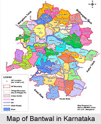
Bantwal is flanked by the state of Kerala in the south, and the towns of Belthangady and Puttur in the east, the city of Mangalore in the west and Karkala in the north. Bantwal covers an area of about 720 km square. The National Highway 48 cuts through B. C. Road. The highway serves as the conduit for several arterial routes leading to neighboring towns with Mangalore. Mangalore is connected with other cities in Karnataka such as Mysore and Bangalore via NH-48.

The Netravati River passes through Bantwal . Some other places in Bantwal of tourist interests are Kadeshivalaya, Ajilamogaru, Alike, Karanje, Naraharibetta, Nandavara and Modankap.

This article is a stub. You can enrich by adding more information to it. Send your Write Up to [email protected]


Share this Article:

Related Articles

More Articles in States of India


East Indian States
East Indian States comprises of Bihar, Jharkhand, West Bengal, Odisha and also the Union Territory of Andaman and Nicobar Islands. It defines the cultural heritage, rich historical background and the linguistic unity.
Erode District
Erode District is one of the districts in the state of Tamil Nadu. The district of Erode is having a land-locked area with no sea coast.
Purnia District in Bihar
Purnia District is located in Bihar and extends from River Ganga to Nepal. The district has a rich Hindu history and glorious past.
South Delhi District
South Delhi District is the third largest district of Delhi as far as its area is concerned. South Delhi District is known for its economic, historical, cultural and social significance.
North Indian States
North Indian States formed the cultural and religious unity in spite of having many foreign invasion and the political disturbances from the early era till the British gained supremacy in Indian sub continent.
Kendujhar District
Kendujhar District, spread over an area of 8,240 sq kms, is as varied as the whole of Orissa with waterfalls roaring gorges, mountains and minerals. The manifold expressions of nature in Kendujhar District are considered as unique.
Hooghly district
Hooghly District along the bank of the river Hooghly is one of the principal trading ports of West Bengal.
Districts of South Tamil Nadu
Districts of South Tamil Nadu consist of many tourism destinations like archaeological sites and the history of Pandyas and Cholas. Considering their proximity to the sea, many districts also boast of serene beaches and coastal beauty.
Flora of Arunachal Pradesh
Flora of Arunachal Pradesh includes infinite species and is a subject of great interests for the botanists.
Districts of South Gujarat
Districts of South Gujarat are the epicenter of Jain pilgrimages and the early Hindu kingdoms.
North West States of India
North West States of India consist of three states, which are Rajasthan, Punjab and Haryana. All of them are culturally and traditionally diverse and they have been ruled by different dynasties in historical time.
Geography Of Chittoor District
Geography of Chittoor district is spread along the topography of the land which is divided into two natural divisions; Chittoor has a dry and healthy climate.
Districts of North Rajasthan
District of Northern part of Rajasthan is dotted with ancient forts and medieval villages.
Districts of North Odisha
District of North Odisha has Bengal boundary and shares the same culture. These are reachable if one pays a weekend visit to Digha.
Districts of West Bihar
Districts of West Bihar is comprised of medieval monuments that were built by the different governors of Mughal era.
Districts of South Haryana
Districts of South Haryana consists of many cities of industrial excellence. These districts are dotted with popular tourism destinations.
Medieval History of Assam
Medieval history of Assam narrates the advent and rule of a number of kingdoms in the region. The prominent dynasties of the kingdom left an everlasting imprint on the socio cultural heritage of India.
Geography of Meghalaya
The suitable climate, highland plateaus, rivers and the flora and fauna together forms the geography of Meghalaya.
Districts of Rayalaseema
Districts of Rayalaseema in Andhra Pradesh state has urban population and rural settlements as well.
Districts of South Punjab
Districts of Southern part of Punjab depict medieval history of Punjab and the rise of Sikhs.