 Archaeological Site in Kutch District means Dholavira. The existence of a new archaeological site, expected to be older than Dholavira by over 15,000 years, near Maruda Takkar hill has been confirmed following research carried out by the Indian Space Research Organisation (ISRO).
If Kutch is described as a district with great history, then it can even be depicted as a region loaded with lots of concealed adventure. Kutch District provides an opportunity to experience the countless stories of human adaptation on this land. Travelling across Kutch District is like tackling a quirky history lesson that got left out in the syllabus of our school and college books.
Dholavira
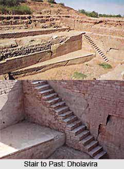
A series of excavations by the Archeological proved that Dholavira ranks, with Mohenjo Daro, Harappa, Ganweriwal now all in Pakistan and Rakhigari in India, was one among 5 largest urban centres of the Harappan civilization. Surveys of India uncovered Dholavira as a major exquisitely planned Harappan city. It had monumental structures, aesthetic architecture and an amazing water management system. The ancient ruins of Dholavira spread over about 100 ha nearly half of which is a fortified settlement. Dholavira was laid out on sloping terrain between to storm water channels, Mansar in the north and Mahar in the south. The city was enclosed by a massive wall, designed like a large parallelogram measuring 771 metres in length and 616 metres in width. It is evident that the site of the settlement was picked after good deal of forethought and planning. The gradient, between the higher east and the lower west of Dholavira is 13 metres, which is ideal location for reservoirs. In fact, along the inside of the city`s walls is a series of water reservoirs, which almost entirely surround the 3 principal divisions of the city, designated Citadel, the Middle Town and the Lower Town. The citadel which stand majestically on the south side consists of 2 fortified divisions on the east and west named castle and Bailey respectively The Middle town, also fortified, lies to the north and is separated from the citadel by a long and wide ceremonial ground. To the east of Middle town is the lower Town, which is not fortified. Dholavira also enjoys the unique distinction of yielding the word`s oldest signboard, comprising an inscription of 10 large sited alphabets of the Harappan script. Plenty of stones were available at Dholavira and were used to make tiles for the water system drains and channels. Pottery pipes were also used. In some places mortar was made of superfine sticky grey clay.
The Hidden Reservoir
Satellite imagery suggests that there should be a large reservoir, most probably an artificial one, buried south west of Dholavira. One of the cultivated fields in the locality with high yields is contagious to this area. Surplus water from within the city wall must escape into this field.
Interestingly, the area around the presumed reservoir is dotted with Harappan funeral structures, including circular elevations that appear to be sepulchral mounds entombing the mortal remains of privileged persons or families. In Indian tradition, funeral rites and the disposal of the dead are performed close to a river, lake of or tank. This tank now hidden would have been ideally suited for special funeral structures.