 Upper Subansiri district is the administrative district of Arunachal Pradesh. Daporijo is the district headquarters. The Upper Subansiri district is one of the beautiful districts of the state of Arunachal Pradesh occupying an area of 7032 sq kms. It has a huge tribal population. The significant towns of this administrative district are Daporijo, Nacho, Siyum, Dumporijo, Taliha, Maro, etc.
Upper Subansiri District
Upper Subansiri District of Arunachal Pradesh is one of the administrative districts of the state. This hilly district is the inhabited by four major tribal groups.
Introduction
Upper Subansiri district is the administrative district of Arunachal Pradesh. Daporijo is the district headquarters. The Upper Subansiri district is one of the beautiful districts of the state of Arunachal Pradesh occupying an area of 7032 sq kms. It has a huge tribal population. The significant towns of this administrative district are Daporijo, Nacho, Siyum, Dumporijo, Taliha, Maro, etc.Geography of Upper Subansiri District
The Upper Subansiri district lies between latitude 27 degrees 45 minutes north and 28 degrees 42 minutes North and longitude of 93 degrees 18 minutes East and 94 degrees 36 minutes East. It is bounded in the north by Mc Mohan line bordering Tibet, in the south by part of Lower Subansiri and part of West Siang districts, in the east by West Siang district, and in the west by Lower Subansiri district. The Upper Subansiri district has an estimated area of around 7000 Sq. Kms. The Upper Subansiri district has its headquarters at Daporijo. It is administered through one sub-division having its headquarters at Nacho. This sub-division includes four administrative circles. The administration of Upper Subansiri district is under the direct control of the Deputy Commissioner.
Demography of Upper Subansiri District
According to the Population Census in the year 2011, Upper Subansiri had population of 83,205 of which male and female were 41,974 and 41,231 respectively. The population of Upper Subansiri District constituted 6.02 percent of total population of Arunachal Pradesh. The population of the Upper Subansiri district shows that density is 12 people per sq. km. The average literacy rate of Upper Subansiri was 63.96 percent. If things are looked out at gender wise, male and female literacy were 67.36 percent and 60.51 percent respectively. The total literates in Upper Subansiri District were 45,984 of which male and female were 24,404 and 21,580 respectively. The main tribal groups of the Upper Subansiri district are Tagin tribe; Hill Miri tribe, Nishing tribe and Gallong Tribe. There is a close co-relation among these four tribes of the district as far as their socio-economic aspects are concerned. Interestingly, all the four tribes live in a well knit social pattern. Most of their traditions and customs have been handed down from generation to generation orally. These traditions and customs are being practised with great devotion.
Culture of Upper Subansiri District
A number of spirits both benevolent and malevolent dominates religious beliefs and practices of the people of Upper Subansiri district. The concept of Supreme God is also prevalent among their customs. Donyi Polo or the Sun-Moon is often regarded as Supreme God. According to their beliefs, every act of human being is supposed to be governed by these spirits. The people of Upper Subansiri district celebrate a number of festivals with complete devotion and collectively. The local people and the tourists attract the festivals of the Upper Subansiri district. There are chiefly four festivals celebrated by the local people of Upper Subansiri district and these are Si-Donyi festival, Bori Boot festival, Boori-Yullow festival and Mopin festival.
Festivals of Upper Subansiri District
 Festivals of Upper Subansiri district mainly reflect the indigenous tribal culture and traditions of this region. The major festivals of this district of Arunachal Pradesh are Si-Donyi festival, Bori Boot festival, Boori-Yullow festival and Mopin festival. These festivals are celebrated with tremendous fanfare and enthusiasm.
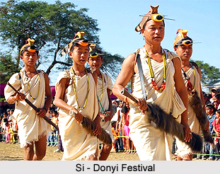
Si-Donyi Festival is celebrated mainly in the month of January every year. It is considered as the most significant festival of the Tagin Tribe who form the largest tribal group in the district. Si-Donyi signifies the Earth and the Sun. The Earth gains the first priority and hence they consider earth as their mother. Si-Donyi festival being conducted on a large scale can not be performed individually because of the huge expenditure involved. Thus, the Tagin tribes celebrate this festival collectively. The local youths work for around a month for the preparation of the festival. The elderly persons from the tribe are responsible for forming the committee that organises the festivals. They also guide the priests in performing the rituals for Si-Donyi puja.
Some of the important mythological dances performed during Si-Donyi festival are -
* Sune-Rabo
* Takar Gene
* Koni-Bokar
* Hoye penam
Boys and girls in colourful dresses perform these dances. People believe that by celebrating the Si-Donyi festival the creators "Si" and "Doni" will be satisfied and will bless the people with good crops and prevent diseases. Si-Donyi festival is described as the festival for prosperity and success.
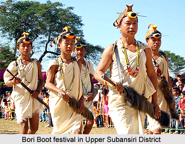
The Hill Miri Tribe of the Upper Subansiri district solely performs Bori Boot Festival. The festival is usually celebrated in the month of February. Bori Boot means to get together irrespective of the age, sex, caste to hail the spring and successful harvest. The festival also invokes the spirit of Bori boot to bless them with prosperity and free them from diseases of any kind. The young members do all the work under the guidance of elders. The `Nibu` or the priest performs puja as well as conducts sacrifices. The celebration of the festival lasts for three days.
Boori-Yullow Festival is the festival of the Nishing tribe. This festival is usually celebrated in the month of February every year for seeking the blessings of the Almighty God for good health and harvest.
The Galo tribes celebrate Mopin Festival. It is performed during the month of April. This festival invokes the Goddess Mopin to bless the people for their prosperity. Prayers are offered for good harvest and to keep them and their cattle free from any diseases. The `Popir` dance is the most popular dance of this festival. Boys and girls in colourful attire participate in this dancing. Eating and drinking goes on during three days long festival.
All these festivals of the Upper Subansiri district are celebrated for obtaining the blessings of the Almighty for good health and prosperity. Another wonderful aspect about this festival is that people celebrate these festivals collectively irrespective of caste and gender.
Administration of Upper Subansiri District
 Administration of Upper Subansiri district of the state of Arunachal Pradesh is managed through one of its sub-divisions. Its headquarters is situated at Nacho. It is located at around 116 kms from the district headquarter that is Daporijo. The sub-division covers four administrative circles along the international boundary. The circle headquarters of Upper Subansiri district are Taksing, Limeking, Nacho and Siyum. The eight administrative circles of the district having their headquarters at Payeng, Taliha, Peeryapu, Daporijo, Puchigeko, Baririjo, Gusar, and Dumporijo are under the direct control of the Deputy Commissioner. The four police stations of Upper Subansiri district are located at Nacho, Taliha, Dumporijo and Daporijo and there is one police out post at Siyum.
The administration of Upper Subansiri district comprises eight Community Development Blocks, which are located at Nacho, Siyum, Taliha, Giba, Daporijo, Puchigeko, Baririjo and Dumporijo. Moreover, the District Rural Development Agency of the district is located at Daporijo. Works on one mega hydro-electric project at Menga River and one small hydroelectric project at Sippi are ongoing under the National Hydroelectric Project Corporation.
The major administrative circles of the Upper Subansiri district are as follows -
Taksing Circle - Taksing Circle was opened in the year 1959 and it is located 195 kms away from Daporijo. The Circle officer is the administrative head. Efforts are being made to restore the Micro-Hydel, which was damaged due to landslide, by reconstruction from government funds.
Limeking Circle - This circle was started in the year 1956 and is 137 kms away from Daporijo Headquarters. Tagin tribes also inhabit this circle.
Nacho Circle - The Nacho circle was opened in the year 1953. The Tagin tribes too majorly inhabit the circle. However, infrastructure required for a Sub-Division headquarters is yet to be developed. Its headquarters at Nacho is located at 108 kms away from Daporijo. This is also a block headquarter covering Taksing, Limeking, Nacho Circle.
Siyum Circle - The Siyum circle was established in 1963 with its head quarter at Siyum. Siyum headquarters is at 73 kms away from Daporijo. The Tagin tribes mainly inhabit it. A police out post was established in the year 1998.
Taliha Circle - Taliha circle is 45 kms away from Daporijo and it was established in 1954. It is an independent Block Headquarter and Circle officer is the Administrative Head. This circle has also a Police Station to assist the local administration.
Dumporijo Circle - This circle was established in 1953 with the Headquarter at Gusar which was later on shifted to Dumporijo headquarters. It is located at a distance of 13 kms from the district headquarters. Tagin and Galo tribes inhabit this circle.
Baririjo Circle - The circle was started in the year 1982 with its headquarter at Baririjo, which is 35 kms away from Daporijo. Inhabitant of this circle is Galo tribe.
Giba Circle - This circle was established in the year 1980. It is located at a distance of 41 kms from Daporijo. It is also a Block Headquarter and the Extra Assistant Commissioner is the administrative head.
Puchigeko Circle - This circle was started in the year 1992 with its headquarters at Puchigeko, which is 40 kms away from Daporijo on the way to Ziro.
Paying Circle - The circle is created bifurcating 11 villages from Taliha circle with its Hq at Payeng. This circle was established on 26th January 1999. It involves a day long foot march to reach the Hq from road head at Taliha. Total population of this circle is 683 as per 2001 census.
Chetam (Peeryapu) Circle - This circle was started in the year 2003 with its headquarters at Chetam.
Guasar Circle - This is a newly created circle of the administration of the district.
These circles and sub-divisions constitute the administrative set-up of Upper Subansiri district.
Tourism in Upper Subansiri District
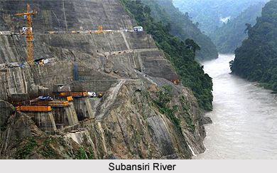 Tourism in Upper Subansiri district in Arunachal Pradesh includes visits to a number of historical places as well as adventurous options. The rugged mountains with unsteady tops of this district of the state of Arunachal Pradesh are considered as an ideal place for hiking, trekking, rock climbing, and more. Moreover, the Subansiri River and its tributaries flowing throughout the district offer ample opportunities for white water sports like, rafting, angling, and boating etc. especially in the winter season.
Pilgrimage Tourism in Upper Subansiri District : The pilgrimage tourism in Upper Subansiri district includes several ancient temples and other locations that have great historical significance associated with them. Menga Mandir is a rock cave temple with two tunnels. The tunnels are located at the backside and towards the left side of cave wall.
The first one starts from the back wall of the cave at a place around 1.80 metres high from the platform reached by stairs. The opening of the tunnel is big and allows single person to enter at a time. Ultimately, it becomes so narrow that a person has to crawl in order to get further entry. The interior of the tunnel is very dark and there are several niches in the passage where three or four persons can stand together.
The second tunnel on the left side appears to be an extension of the cave. The ceiling of this tunnel is near about 0.90 metres from the floors of the cave. Further, on the floor there is a `Lord Shiva Linga` like object of black stone. Water drips on the Linga from the ceiling and accumulate on it. The accumulated water hardens because of which the size of the Linga increases. This rock cave is known as the Menga Mandir. During Shivaratri devotees from the neighbouring areas of Daporijo visit this place for offering prayers and for perform puja. Of late, this Mandir has become a place of interest for the domestic as well as foreign tourists. It is located around 22 kms North of Daporijo towards Taliha, near the convergence of river Subansiri and Menga River.
Leisure Tourism in Upper Subansiri district : Leisure tourism in Upper Subansiri district includes several places like Abi-Siriu Lake and Likusui.
Likusui : Likusui is a cold-water spring where numerous migratory birds could be seen in the early winter season. It is an ideal place from where one can watch diverse range of birds. It is situated near Maro under Baririjo Circle, around 45 kms away from Daporijo.
Abi-Siriu Lake is a natural lake situated near Taliha Circle headquarters. Interestingly, the lake is believed to be inhabited by evil sprits and therefore it is hardly visited by the local people. This lake is yet to be explored fully. Through the proper development of infrastructure facilities, this lake could be made one of the hot spot destinations for hiking, trekking, boating for the tourists.
Libe Langne is a pair of stone believed to be mysterious by the local people of the district. Local people believe that there is no such type of stone in the entire surrounding areas. Even when it is thrown away, it is said to return to its original position. These are some of the tourism spots of the Upper Subansiri district that attract a huge number of people from different parts of the world.
Recently updated articles in States of India

History of Thissur District
Early History of Thissur District explains flourishing of the port cities. Now these port cities are transformed into archaeological sites.

Tippi Orchid Research Centre, Arunachal Pradesh
Tippi Orchid Research Centre in Arunachal Pradesh is renowned for its rich collection of exotic and endangered orchids. Surrounded by lush rainforest...

Tourism in Nashik District
Pilgrimage tourism in Nashik district involves visiting the various places of Hindu and Jain worship located here. Some of the holiest sites for Hind...

Mangadu, Kerala
Mangadu in Kerala’s Kollam district is a significant megalithic site known for its urn burials, cist burials, menhirs, and stone circles. Excavations...

Devaswom
History of Devaswom is not very ancient and can be dated back to late seventeenth century.
Related articles in States of India

East Indian States
East Indian States comprises of Bihar, Jharkhand, West Bengal, Odisha and also the Union Territory of Andaman and Nicobar Islands. It defines the cult...

Purnia District in Bihar
Purnia District is located in Bihar and extends from River Ganga to Nepal. The district has a rich Hindu history and glorious past.

Hooghly district
Hooghly District along the bank of the river Hooghly is one of the principal trading ports of West Bengal.

Geography Of Chittoor District
Geography of Chittoor district is spread along the topography of the land which is divided into two natural divisions; Chittoor has a dry and healthy...

Districts of West Bihar
Districts of West Bihar is comprised of medieval monuments that were built by the different governors of Mughal era.