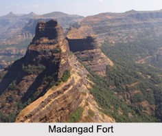
 Also known as the Madan Fort, the Madangad Fort is located in the Kalsubai range in the Nashik district in the Indian state of Maharashtra. The fort is situated at an elevation of 4,900 ft and is part of a combined trek consisting of two other nearby forts namely the Alang and Kulang forts.
Overview of Madangad Fort
Compared to the other two forts, the top of the Madangad Fort is a relatively small and tilted plateau. The Madangad Fort has no manmade structures and on the premises of the fort, there are caves and two rock- cut water cisterns. The fort is surrounded by the Alang and Bitangad forts and the Kalsubai range in the east, while the Harihar, Trymbakgad and Anjaneri forts lies to its north. The Kulang Fort is to the west of Madangad and the forts of Aajobagad, Harishchandragad, Kutta, Ratangad are all towards its south.
The dense forests surrounding the area around the fort and no specific marked routes, makes the trek leading up to the Madangad Fort quite difficult. Most of steps are destroyed due to the firing of cannons during various invasions. After this rock path of around 40 ft is climbed, it takes a detour to the western route through a very narrow ridge. Another way towards the fort is from Ghatghar. The entire trek takes almost 3 to 4 hours and is an adventurous journey for trekkers.
Visiting Information on Madangad Fort
The nearest railway station is at Igatpuri at a distance of 20 km from the fort and the Chhatrapati Shivaji International Airport is the closest at a distance of almost 139 km from the Madangad Fort.
This article is a stub. You can enrich by adding more information to it. Send your Write Up to content@indianetzone.com.