Introduction
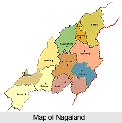 Nagaland has 11 administrative districts. Nagaland is a vibrant hill state located in the extreme North Eastern end of the country. This state is bounded by Myanmar in the east; by Assam in the west; by Arunachal Pradesh and a part of Assam in the north with Manipur in the south. Districts of Nagaland are headed by district magistrates or deputy commissioners. Each district is under the administration of a deputy commissioner and he is assisted by other officials, who are in charge of the different wings of the district administration. Maintenance of law and order in a particular district of Nagaland is the responsibility of Superintendent of Police.
There are 11 districts in Nagaland and these are mentioned below -
* Dimapur District
* Kephire District
* Kohima District
* Longleng District
* Mokokchung District
* Mon District
* Peren District
* Phek District
* Tuensang District
* Wokha District
* ZunZunheboto District
Districts of Central Nagaland
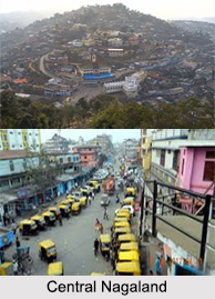 Districts of Central part of Nagaland include Zunheboto District, Dimapur District and Tuensang District.
The central part of Nagaland is full of natural beauty and serenity. This will always be every adventurer"s dream. The breath taking hillock, the striking mountains, the beautiful streaming lakes are picture perfect. In the central area of Nagaland, a stream or lake will be there to surprise one every time and one will decide to go for a trek out in the wilderness. There are several brooks and tributaries, flowing freely within the state making the trip Nagaland a truly memorable one.
Zunheboto District : Zunheboto District is a district of Nagaland state in India. It is located in the central part of Nagaland. "Zunheboto" derived its name from two sets of words "Zunhebo" and "To" in Sumi dialect. Zunhebo is the name of a flowering shurb with white leaves, which bear sponge like ears containing sweet juice, and "To" means the top of a hill. Zunheboto District is the home of the Semas Tribe. They are famous for their colourful war dances and folk songs. Sumis in general in those days had so many traditional festivals in sequence of seasons of the year. Even these days, two main festivals, Tulunih Festival and Ahunah Festival are celebrated with gaiety and grandeur by young and old. These two festivals also promote the tourism sector here.
Dimapur District : Dimapur District is a district of Nagaland state in India. Its headquarters is Chumukedima. As of 2011 it is the most populous district of Nagaland. Dimapur Jain Temple was built in 1947. This is one of the prime attractions here. The temple is architecturally very well built and has an impressive structure. The temple has some intricate glasswork. The temple is considered very auspicious by the people of Dimapur. The temple was built by the tireless effort of Shri Nandlal Mangilal Jain and his family, Shri Kanhaiyalal Pannalal Sethi and family, Shri Phulchand Sethi, Shri Jethmal Sethi, Shri Udayram Chabra, Shri Chunnilal Kishanlal Sethi, Mangal chand Megh raj family and other Jain families present in Dimapur at that time. During the Second World War, Dimapur was the centre of action between British Government in India, Azad Hind Fauz and the Imperial Japan. It was the staging post for the Allied Offensive. The Japanese could reach Kohima where a siege was laid. The Allied reinforcement came through Dimapur by rail and road for the push against the Japanese. An airport at Dimapur was also in use for supplies to the allied forces in Burma. The battle for Kohima about 77 km from Dimapur is considered the turning point for the retreat of Azad Hind Fauz led by Subhas Chandra Bose and Japanese Army from South East Asia.
Tuensang District : Tuensang District is the largest and the eastern most district of Nagaland, a state in North-East India. Its headquarters is Tuensang. This district is known as the land of culture. Tuensang District is located in the eastern part of Nagaland. It is bounded by Mon District and Longleng District in the north and north east respectively, Mokokchung District in the northwest, Zunheboto District in the southwest, Kiphire District in the south, and Myanmar in the east.
Districts of North Nagaland
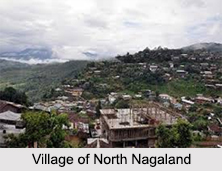 Districts of North Nagaland include the districts like Mon District, Longleng district, Mokokchung District and Wokha District.
Mon District : Mon District is a district of Nagaland state in India. Mon district is the northernmost district of Nagaland. It is bounded by the state of Arunachal Pradesh to its north, Assam to its west, Myanmar to its east, Longleng district to its south-west and Tuensang district to its south. The town of Mon is its district headquarters.
Longleng District : Longleng district is one of the eleven districts of the Indian state of Nagaland. It is the eighth least populous district in the country (out of 640). Longleng district was carved out from Tuensang district. Longleng District is tenth district of Nagaland. It is bordered by Mon district in the north, Mokokchung district in the west and Tuensang district in the south. The district`s headquarters is Longleng, which is at an altitude of about 1,066 m above sea level. Tamlu and Longleng are the major towns in the district. Its main river is Dikhu.
Mokokchung District : Mokokchung is a district of Nagaland. The town of Mokokchung is its headquarters. It is the home of the Ao Naga tribe. It covers an area of 1,615 square km. It is bounded by the state of Assam to its north, Wokha district to its west, Tuensang and Longleng district to its east, and Zunheboto district to its south.
Wokha District : Wokha District is a district of Nagaland. The State Government of Nagaland declares Wokha district as “the land of plentyâ€. It is due to her rich mineral resources, soil fertility and abounding flora and fauna. Wokha District is located at the latitude of 26 degree 8 minutes North and Longitude of 94 degree18 minutes East. Wokha District is situated at an economically strategic location sharing borders with Assam in the West and North, Kohima District and Dimapur District in the South, Zunheboto District in the East and Mokokchung District in the North East. Wokha in Wokha District is the third largest town in Nagaland after Dimapur and Kohima. According to the Population Census in the year 2011, the population is 166,269. Wokha has an average literacy rate of 85.67 percent; the male literacy rate is 86.98 percent, while female literacy rate is 84.26 percent. In Wokha, 10.57 percent of the population is under 6 years of age. Kyong is the most widely used language for communication, while Nagamese and English are also used with non-locals. The majority of the population is Christian, mostly adhering to the Baptist denomination.
Districts of South Nagaland
 Districts of South Nagaland include districts like Kiphire District, Phek District, Kohima district and Peren District.
Kiphire District : Kiphire District is the newly formed ninth district of Nagaland, which was carved out of Tuensang district. As of 2011 it is the second least populous district of Nagaland (out of 11), after Longleng District. Kiphire is a small town. It is situated at an elevation of 896 m above sea level and is the headquarters of the newly formed Kiphire district, carved out of Tuensang district, in Nagaland, India. Kiphire is about 254 km from Kohima, the capital of Nagaland. It is the place where the Naga tribes of Sangtam (Eastern), Yimchunger and Sema tribes meet. The town is the nearest district headquarters to Mt. Saramati (3841 m or 12,602 ft), which is the highest peak of Nagaland.
Phek District : Phek District is a district of Nagaland state in India. It was organized in 1973. Phek district has a population of 163,294. Phek District has a sex ratio of 951 females for every 1000 males, and a literacy rate of 79.13 percent.
Kohima District : Kohima district is a district of Nagaland state in India. It is the home of the Angami Naga tribe. As of 2011 it is the second most populous district of Nagaland (out of 11), after Dimapur. In 1980, Kohima district became home to the Puliebadze Wildlife Sanctuary, which has an area of 9.2 square kilometers. It is a natural habitat for Blyth"s Tragopan. Kohima is the land of the Angami Naga tribe. It is situated in the foothills of Japfu range located south of Kohima District. It has an average elevation of 1261 meters.
Peren District : Peren District is the eleventh and newest district of Nagaland. It has been formed by the partition of Kohima district. Peren District is bounded by Dima Hasao District and Karbi Anglong district of Assam in the west and Dimapur district to the northeast. Kohima district in the east and Tamenglong district of Manipur in the south are the other boundaries. In 1993, Peren district became home to Ntangki National Park, which has an area of 202 square kilometers.