Home > Travel > States of India > Longleng District
Longleng District
Longleng District is one of the eleven districts of the Indian state of Nagaland that is a strip of mountainous territory devoid of plains.

Share this Article:

Longleng DistrictLongleng District is a region that occupies the elongated northern part of Nagaland State. Located at an altitude of the District varies from 150 Metres to 2000 Metres above the sea level, Longleng Town, the Headquarter of the district is around 1100 Metres above sea level.

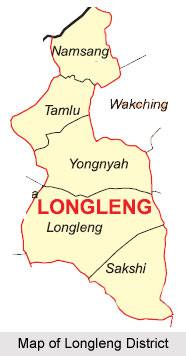
Geography of Longleng District
Longleng District has three district boundaries. On the East it shares boundary with Tuensang and Mon district of Nagaland and on the North it has Nagaland`s Inter-State boundary with Assam. On the west it shares boundary with Mokokchung District of Nagaland and on the south it shares boundary with Tuensang district of Nagaland. Longleng district enjoys monsoon type of climate with a minimum temperature of 10 øC in winter and a maximum of 28 øC in summer. The district has a fairly moderate climate where days are warm and nights are cool. Rainy season sets in during the month of May and lasts till October. From November to April, the District has dry weather relatively cool and days are bright and sunny. The average rainfall is between 2000mm and 3000mm. Tamlu and Longleng are the major towns in the district. Its main river is Dikhu.

Longleng District Economy of Longleng District
Rice is the stable food and agriculture is the main stay of the people of Longleng District. Jhum cultivation is the most common form of agriculture, though wet paddy cultivation is seen practiced by a few in recent times. Some of the agricultural products include rice, maize, varieties of vegetables, horticultural crops, etc. The low lying areas/Foothills of the District (bordering with Assam) is fertile and has the potential for wet paddy cultivation. Very few of the people are engaged in white collar jobs and majority of the people are agriculturists.

Demography of Longleng District
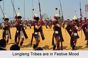
The population of the district is mainly tribe based. The Phom Nagas inhibit Longleng who are exceptionally good with pottery, spinning and bamboo work. Traditionally, the Phom Nagas have forayed into the occupation of agriculture. The origins of the Phoms can hardly be ascertained, but from oral tradition it can be deduced that this tribal group even emerged from the similar source as like the Ao Nagas. Phom Nagas have mostly converted into Christianity and thus have modernized to a large extent. However, during festivals they can still be found wearing Vihe-Ashak or Nempong-Ashak, which are shawls wrapped around the body. The Monyu Festival that is celebrated to herald the summers is celebrated with much pomp and fanfare. It also bids farewell to the winters. It is a six-day affair held during the month of April, right after sowing. Monyu is one of the main festivals of the Phom Nagas.


Share this Article:

Related Articles

More Articles in States of India


East Indian States
East Indian States comprises of Bihar, Jharkhand, West Bengal, Odisha and also the Union Territory of Andaman and Nicobar Islands. It defines the cultural heritage, rich historical background and the linguistic unity.
Erode District
Erode District is one of the districts in the state of Tamil Nadu. The district of Erode is having a land-locked area with no sea coast.
Purnia District in Bihar
Purnia District is located in Bihar and extends from River Ganga to Nepal. The district has a rich Hindu history and glorious past.
South Delhi District
South Delhi District is the third largest district of Delhi as far as its area is concerned. South Delhi District is known for its economic, historical, cultural and social significance.
North Indian States
North Indian States formed the cultural and religious unity in spite of having many foreign invasion and the political disturbances from the early era till the British gained supremacy in Indian sub continent.
Kendujhar District
Kendujhar District, spread over an area of 8,240 sq kms, is as varied as the whole of Orissa with waterfalls roaring gorges, mountains and minerals. The manifold expressions of nature in Kendujhar District are considered as unique.
Hooghly district
Hooghly District along the bank of the river Hooghly is one of the principal trading ports of West Bengal.
Districts of South Tamil Nadu
Districts of South Tamil Nadu consist of many tourism destinations like archaeological sites and the history of Pandyas and Cholas. Considering their proximity to the sea, many districts also boast of serene beaches and coastal beauty.
Flora of Arunachal Pradesh
Flora of Arunachal Pradesh includes infinite species and is a subject of great interests for the botanists.
Districts of South Gujarat
Districts of South Gujarat are the epicenter of Jain pilgrimages and the early Hindu kingdoms.
North West States of India
North West States of India consist of three states, which are Rajasthan, Punjab and Haryana. All of them are culturally and traditionally diverse and they have been ruled by different dynasties in historical time.
Geography Of Chittoor District
Geography of Chittoor district is spread along the topography of the land which is divided into two natural divisions; Chittoor has a dry and healthy climate.
Districts of North Rajasthan
District of Northern part of Rajasthan is dotted with ancient forts and medieval villages.
Districts of North Odisha
District of North Odisha has Bengal boundary and shares the same culture. These are reachable if one pays a weekend visit to Digha.
Districts of West Bihar
Districts of West Bihar is comprised of medieval monuments that were built by the different governors of Mughal era.
Districts of South Haryana
Districts of South Haryana consists of many cities of industrial excellence. These districts are dotted with popular tourism destinations.
Medieval History of Assam
Medieval history of Assam narrates the advent and rule of a number of kingdoms in the region. The prominent dynasties of the kingdom left an everlasting imprint on the socio cultural heritage of India.
Geography of Meghalaya
The suitable climate, highland plateaus, rivers and the flora and fauna together forms the geography of Meghalaya.
Districts of Rayalaseema
Districts of Rayalaseema in Andhra Pradesh state has urban population and rural settlements as well.
Districts of South Punjab
Districts of Southern part of Punjab depict medieval history of Punjab and the rise of Sikhs.