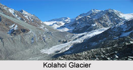
 Kolahoi Glacier is a valley glacier in the north-western Himalayan Range situated 26 kms north from Pahalgam and 16 kms south from Sonmarg, in the state of Jammu and Kashmir. It is a hanging glacier located just beneath the Kolahoi Mountain and above the Lidder Valley. Known as "Gwash Brani" meaning "Goddess of Light", the Kolahoi Glacier in Pahalgam is considered to be the only perennial source of water for millions of Indian and Pakistani people.
Geography of Kolahoi Glacier
Kolahoi Glacier lies at an average elevation of 4,700 metres (15,400 ft). The highest peak named after the glacier is "Kolahoi Peak" that has an elevation of 5425 meters. The origin of the glacier is below the cirques on the north flank of Kolahoi Peak. It is the source of Lidder River and some melt waters become the tributaries of the Sindh River. Its water serves the population of Anantnag district, where it is mainly being used for drinking and agricultural purposes. The water finally discharges itself into Jhelum River near Khanabal.
Environmental Threat to Kolahoi Glacier
Kolahoi Glacier is among the victims of global warming, and has shrunk in area from 13.57 sqkm in 1963 to 10.69 sqkm in 2005. According to another report, Kolahoi is a hanging glacier and is hollowed inside. Kolahoi glacier, which is the largest in the valley and which also feeds its main river, is melting faster than other Himalayan glaciers. It is a matter of great concern for Kashmir Valley. Many expeditions have failed here.
Best Time to Visit Kolahoi Glacier
Summers are said to be a good season to visit these glaciers as during winters and rainy seasons, the land is almost inaccessible. One must reach Kolahoi by noon as it gets clouded post noon and the glacier is therefore barely visible from a distance.
Trekking in Kolahoi Glacier
Usually trekking up to the Kolahoi Glacier is a 4-day activity which provides the trekkers ample amount of scenic beauty and freshness to stay interested. The path is covered with lush green mountain vegetation and green meadows.
This article is a stub. You can enrich by adding more information to it. Send your Write Up to content@indianetzone.com


