Introduction
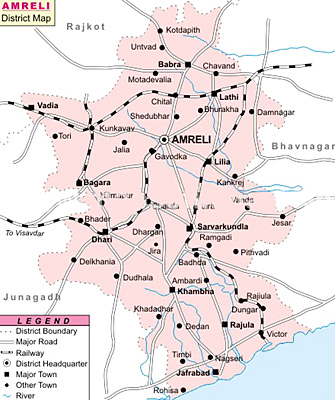
Amreli district is located in the western part of Gujarat. The district has eleven talukas, of which the major ones are Amreli, Babra, Rajula, Bagasara, Jafrabad, Savarkundla and Vadiya. The total are of the district is 7397 sq km. the district head quarters is at Amreli. Total population of the district is 1.39 million as per 2001 Census. Population density is 188 persons per sq. km. Sex ratio of the place is 987 Females per 1000 Males and the literacy rate 66.10 percent.
Geography of Amreli District
Geographical location of Amreli district is 70.30 degrees to 71.75 degrees East Longitude and 20.45 degrees to 22.25 degrees North Latitude. Average rainfall of the place is 550 mm. Major rivers of Amreli district are Shetrunji, Gagdio, Thebi, Dhatarwadi, Shanti, Vadi and Rayadi.
Education of Amreli District
There are 966 primary, 171 secondary and higher secondary schools present in Amreli district. There is one Government polytechnic college in the district which offers engineering courses in the fields of electronics, mechanical and civil. There are two Pharmacy College and one Management College in the district.
Economy of Amreli District
Economy of Amreli District in Gujarat is chiefly dependent on cement, ports, metallurgical, electrical equipments, and ship building industries. Owing to the presence of great reserves of limestone, a number of major cement conglomerates, such as Larson and Toubro and Ultra Tech Cement Co. Ltd have established their manufacturing facilities in Amreli. Excellent port connectivity with the presence of Pipavav port makes port and ship building industry the most important industry in the district. More than 5,455 units of Small and Medium Enterprises (SME`s) are present in Amreli district. Savarkundla taluka is known for the production of engineering equipments (weighing materials and machines) in Gujarat.
Major crops which are being produced in the district are sesame, groundnut, cotton, jowar and bajra. Limestone is the most important mineral found in the district. Besides limestone, the district is also known for gypsum, natural clay, salt, and black stone. In the ten talukas of the district, over 5,455 units generate 17,845 jobs. Maximum numbers of small scale industries are occupied in embroidery products, textiles and wooden boxes. Savarkundla taluka has witnessed the highest number of SSI units with a healthy investment.
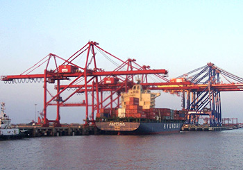
Amreli District is emerging as a center for port-based, minerals, engineering and cement industries. The development of Pipavav port to handle Liquefied Petroleum Gas (LPG) and developed port infrastructure of handling 22 million metric tonnes per annum (MMTPA) of general cargo and containerised cargo has made it a gateway port. The port facility present at Pipavav would help in attracting investments in the future as well. Emergence of an LPG terminal, quite a few new power projects and captive jetty industries in Pipavav by industries such as GSPC, Torrent Power, Ultratech Limited and Videocon are likely to further fuel the economic development of the district.
Rise of new sectors in the district, such as electrical equipments, engineering, and infrastructure projects has led to the expansion of Amreli as a flourishing industrial belt. The Government of Gujarat has started a road project connecting Pipavav to Ahmedabad directly. This is expected to boost the commercial activity and easy movement of logistics in the district, due to the propinquity of Ahmedabad with Delhi-Mumbai Industrial Corridor (DMIC).
Tourism in Amreli District
Tourism in Amreli district, Gujarat, is famous for its abundance of magnificent temples. In addition to attracting a number of devotees, the impressive temple architecture also invites the tourists to explore the ancient artistry of India. Amreli district is also a rich storehouse of diverse flora and fauna, including the endangered ones which have been well preserved here. Other than these, ancient palaces and places of scenic beauty have also made tourism in Amreli district highly alluring.

Gir Wildlife Sanctuary: Gir Wildlife Sanctuary is one of the most attractive tourist destinations in Amreli district. It is located at southwest of the peninsular state of Gujarat. It spans an area of about 116 square-miles. The sanctuary was established in the year 1965 with the purpose of protecting the remaining wild population of lion outside the regions of Africa. Presently it is the only shelter of Asiatic lions. Owing to the efforts of wildlife activists, forest department and NGOs, the area gained the status of a protected area in 1900, by the declaration of the Nawab of the Princely State of Junagadh. Various lion breeding programs run in the sanctuary which has helped in augmenting the number of lions. It is also home to a vast variety of flora and other species of animals. Gir wildlife sanctuary is greatly famed for the conservation of Asiatic lions in the country.
Nagnath Temple: Nagnath temple is a renowned temple of Amreli district. It was built by Late Diwan of Amreli. The temple is known for the magnificent architecture that adorns this beautiful temple.
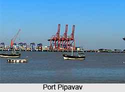
Port Pipavav: Port Pipavav is the first private port of the country. It also owns the credit of being the third largest container terminal operator that occupies an area of about 6760 square kilometres. The port has one LPG / liquid cargo berth and three dry cargo berths. These three dry cargo berths are equipped with instruments which can handle multipurpose cargo and span a length of about 725 metres.
Other Tourist Places of Amreli District
Amreli district is further adorned with a number of temples including Balaji Hanuman Temple, Kamnath Temple, Gayatri Temple, Tapovan Temple, Bhimnath Temple, Khodiyar Temple, Bhurakhiya Hanuman Temple and Rokadia Hanuman Temple. Apart from these, Dhari town, Untvad town, Mandanka Nivas and Rajmahal Palace are other tourist attractions of the district.


