Introduction
 Gadchiroli district was carved out on the 26th of August 1982 by the division of erstwhile Chandrapur district. Earlier, it was a part of Chandrapur district and only two places namely Gadchiroli and Sironcha were tahsils of Chandrapur district before the formation of Gadchiroli district. The district is categorized as a tribal and undeveloped district and most of the land is covered with forest and hills. This district is famous for bamboo and tendu leaves. Paddy is the main agricultural produce in this district. The tribals in the district have a culture all of their own, and the district is famous for tribal folk dances such as Dander, Gondi and Gondhali.
Location of Gadchiroli District
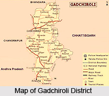
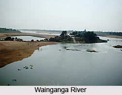
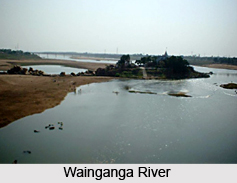
Gadchiroli district is located on the north-eastern side of the state of Maharashtra in the Deccan plateau. It is situated between 18.43 to 21.50 north latitudes and 79.45 to 80.53 east longitudes. The districts adjoining Gadchiroli district are Durg and Rajnandgaon district of Chhattisgarh on the east, Chandrapur district on the west, Bhandara on the north and Karimnagar district and Adilabad district of Andhra Pradesh and Jagdalpur district of Chhatisgarh on the south. The District Headquarters is situated at Gadchiroli which is 180 Kms away from Nagpur and 80 Kms away from Chandrapur and 200 Km from Bhandara. The district is surrounded on the west, south and east by the Wainganga River, Godavari River and Indravati River respectively.
Geography of Gadchiroli District
 Geography of Gadchiroli district has a largely undulating topography except a narrow strip along the Godavari River and the Pranhita River. The major physiographic features of the district are Sirkonda, Bhamragad, Aheri and Dandkaranya hill ranges with high to moderate relief. The lowland of the district shows rolling topography with isolated hillocks. The eastern part of district ie Dhanora, Etapalli, Aheri and Sironcha talukas form a somewhat higher part of the district and are covered by thick forests. Hills are located in the area of Bhamaragad, Tipagad, Palasgad and Surjagad in the district. Gadchiroli district experiences extreme variations in temperature with very hot summers and very cold winters and an average relative humidity of 62 percent. The district receives rainfall from the South-Western winds, mainly in the months of June, July, August and September. July and August are the months during which the maximum rainfall as well as maximum continuous rainfall occurs.
The entire Gadchiroli district is included in the drainage basin of the Godavari River. At the south western boundary of the district, near Sironcha, Godavari enters the district and flows eastwards for about 50 Kms along the southern boundary of the district. After its confluence with the Indravati River, at the south-eastern corner, the Godavari turns south into Andhra Pradesh. The western boundary runs for a distance of 225 Kms and is formed by the flow of the Wainganga River which divides Chandrapur district and Gadchiroli district. Khobragadi, Kathani and Mirgadola rivers are the major tributaries. The Pranhita River, formed by the confluence of the Wainganga and Wardha river, forms the south-western boundary for 190 Kms till its confluence with the Godavari. Dina River is the main tributary. The Indravati River enters Maharashtra near the Kowande village of Bhamragad Tehsil in the district and forms the south-eastern boundary for a distance of 120 Km before joining the Godavari. Parlkota (Nimbra), Pamulgautam (Kotari) and Bandia are the major tributaries. Apart from these, the major rivers flowing through the district are the Gandhavi, Pal welochanna, Siwani, Por and the Darshani.
The predominant soil cover in the district is clay, clay-gravel, sandy loam, deep black soil, reddish and yellowish brown soils on hill slopes, brown and gray soils of plains and laterite and lateritic soil. Out of the total geographical area of 14412.0 Sq.Kms, 11694.0 Sq.Kms of the land is included in the reserve or protected forest category. Out of the remaining area, only 1960.0 Sq. Kms of the land is under cultivation and constitutes only 13.14 percent of the total land of the district. Iron ore, base metals, barrettes, limestone, corundum, talc are some of the important economic minerals occurring in the district. The district can be divided into six geomorphic units of structural, denudational and fluvial origin.
Structural Origin: Structural Hill/ Ridges-Lithologically these consist of metamorphic rocks of Archaean and Proterozoic age.
Denudational Origin: Denudational Hills, Pediments / Pediplains-Denudational hills are low relief hills mostly covered with vegetation. While Pediments are concave surfaces developed at Junction of hills with the plains and exhibit undulating topography and are dissected.
Fluvial Origin: Older and Younger Alluvial Plains
The Wainganga and Godavari have developed extensive alluvial deposits along their courses. The older alluvial plain is a flat surface of large aerial extent gently sloping towards these rivers and representing an earlier cycle of deposition. The unconsolidated material in this unit consists of sand silt and kankar with thickness as high as 30 m. The younger alluvial unit represents a later cycle of deposition.
Demography of Gadchiroli District
According to the last Census (2001), the total population of the district is 9, 70,294. Male and female population is 4, 91,101 and 4, 79,193 respectively. Schedule Caste and Schedule Tribe population in the district is 1, 08,824 and 3, 71,696. The literacy rate of the district is 60.1. The Tribal Community population that resides in the district is 38.3 percent.
Administration of Gadchiroli District
 The district is divided into three Sub-Divisions i.e. Gadchiroli, Aheri and Desaiganj respectively and each sub-division has four talukas. There are 467 Gram Panchayats and 1688 Revenue Villages in the district. The district has three Legislative Assembly Constituencies namely Gadchiroli, Armori and Sironcha. Basically, the district is distributed into 12 talukas and 12 Panchayat Samitis. Only, two municipalities exist in the district i.e. at Gadchiroli and Wadsa.
Culture of Gadchiroli District
Most of the people living in the district are of the tribal community. Due to the high population of tribals here, the district has been categorised as a tribal district. The major community of tribals that reside in the district are the Gond tribe, Madia, Pardhan and Kolam. They have their own languages such as the Gondi language, Madiya etc. The tribals in the district have their own culture. They worship their own God known as Persa Pen among others. The dance Rela is quite popular among the tribals and is performed by them on auspicious occasions, and when new harvest comes in. The other dance is Dhol dance. Holi, Dussehra and Diwali are the main festivals of the tribals. The tribal community families reside in the dense forests of the district. People from other communities also celebrate the various festivals, such as Ganpati, Dussehra, Holi, and Diwali. In some parts of the district, the villagers arrange for natak and tamasha on the occasion of Shankar-Pat in the month of January and February. Cultural programs like Dandar are also arranged on festivals days. Seven languages are spoken in the district i.e., Gondi, Madiya, Marathi language, Hindi language, Telugu language, Bengali language and Chattisgarhi language.
Economy of Gadchiroli District
The district is categorized as tribal and undeveloped district and most of the land is covered with forest and hills. The main profession of the people is farming. Paddy is the main agricultural produce in this district. The other agriculture produce in the district includes jowar, linseed, tur and wheat. There are no large scale industries in the entire district except the Paper Mill at Ashti in Chamorshi Taluka and Paper Pulp Factory at Desaiganj. There are many Rice Mills in the district as paddy is the main agriculture produce here. The Tussar Silk Worm Centre exists in Armori taluka of the district.


