
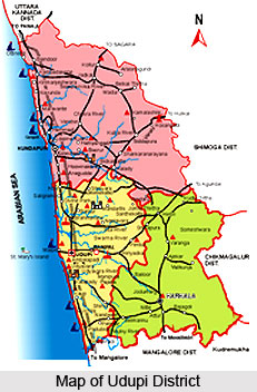
Udupi district is one of the most recently formed districts of Karnataka. It came into existence in the year 1997. It is situated between the two other maritime districts of Uttara Kannada District and Dakshina Kannada District. It is bounded by the Shimoga district and Chikmagalur district in the East and to the West lays the Arabian Sea.
Geography of Udupi District
Udupi district covers a total length of 109 Kms from Shiroor in the North to the Mulki River in the South. The district lies between 13 degrees 04 minutes and 13 degrees 59 minutes North latitude and 74 degrees 35 minutes and 75 degrees12 minutes East longitude covering an area of 3575 sq km. It is about 88 km in length and about 80 km in widest part.
The Udupi district can be broadly divided into three regions. These include the densely populated coastal region, the undulating interior region and the region of the Western Ghats Mountain Range, with evergreen thick forests rich in flora and fauna. Among the few rivers that originate here in the Western Ghats region and flowing towards the west to join the Arabian Sea, Seetha, Swarna, Varahi and Gangolli are the main rivers. These rivers are perennial during normal rainfall years, whereas the tributaries and smaller streams become dry during summer. These rivers join Arabian Sea and are prone to tidal effects to considerable lengths in the inland area.
Udupi district falls under number 10 coastal zone. The climate here is characterised by excessive humidity during the greater part of the year. The average rainfall is 4209 mm. Of the total rainfall received, 80 percent of the rainfall is received during June to August. The temperature ranges from 21 degree Celsius in December to 36 degree Celsius in April.
The district of Udupi is primarily agricultural in nature. More than 80 percent of the population depends on agriculture for their livelihood. However, only 40 percent of the available land is used for agriculture. Rest is either forest land or land unsuitable for agriculture.
Economy of Udupi District
Agriculture is confined mainly to the valley area and is by and large confined to the traditional kharif cultivations depending on the monsoon. There is no any major irrigation scheme in Udupi district. The minor irrigation schemes include both surface water and ground water schemes. The main crops grown in the district are paddy and pulses, sugarcane, groundnut and coconut in the coastal region. In the inter land are found coconuts and areca nuts, and the region of the Western Ghats remains covered in evergreen forests. Among the other crops grown in the district are horticultural crops like mango, sapota, cashew, banana, jackfruits etc.
The Udupi district comprises three talukas, namely Udupi, Kundapur and Karkala. There are 9 hobilies, 146 Grama Panchayats and 244 inhabited villages in the district. The administration of the Udupi district is carried out by the Deputy Commissioner. For the purpose of effective implementation of the development schemes of the district and facilitating administration at the grassroots, the Zilla Panchayat has been established. The Zilla Panchayat is headed by the Chief Executive Officer. Education in the Udupi district is quite well managed. There are a number of aided schools, social welfare as well as SSA schools.









