 Hazaribagh is an urban area and beautifully maintained because of the rush of the tourists from Kolkata, Delhi and Odisha. This city in Jharkhand has many tourism destinations.
Naming of Hazaribagh
The word "Hazaribagh" is made of two Persian words- "Hazar" meaning `one thousand` and "bagh" meaning `garden`. The meaning of Hazaribagh is derived as the `city of a thousand gardens`.
Location of Hazaribagh
Hazaribagh is located in the Hazaribagh district in Jharkhand.
History of Hazaribagh
Hazaribagh has the historical significances of Indian forestry. This area was free from external invasion till British East India Company came in India. Only Grand Trunk Road was formed in mid 9th Century for the trade from Bengal (West Bengal). A tower of medieval era is now in very dilapidated condition which proved the presence of Hazaribagh. During the rule of British Empire in India, Hazaribagh was the connecting spot between West Bengal and Odisha. Grand Chord railway line was opened in 1906. From that Hazaribagh Road railway station became the link.
Geography of Hazaribagh
Hazaribagh is located geographically near the Chotanagpur Plateau. Konar River is flowing through the entire Hazaribagh. Hazaribagh has been a thick forest earlier and is still surrounded by eastern highlands moist deciduous forests and waterfalls.
Demography of Hazaribagh
According to the Population census in the year 2011, Hazaribagh had a total population of 153,599, out of which the males were 80,095 and females were 73,504 respectively.
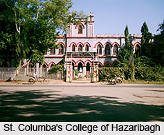 Education of Hazaribagh
Annada College, J.N.V (Jawahar Navodaya Vidyalaya), Gulmohar Inter College, Vananchal College, God Grace Public School and many more are the popular educational institutions here. Hazaribagh has the police training centre for Jharkhand. Border Security Force (BSF) is present here, as the school for BSF is located here.
Administration of Hazaribagh
Hazaribagh is the divisional headquarters of North Chotanagpur division. It is represented in the Indian Lok Sabha by its Member of Parliament.
Economy of Hazaribagh
Hazaribagh has the second highest coal reserve in Jharkhand.
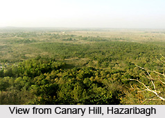
Tourism in Hazaribagh
Barso Pani Cave, Budhwa Mahadev Mandir, Chadwa Dam, Hazaribagh Lake, Hazaribagh National Park, Cannary Hill, Konar Dam, Narsingh Temple, Kodarma, Surajkund hot Spring, Tilaiya Dam are the popular tourism destinations in Hazaribagh.
Visiting Information
Hazaribagh is connected to capital city Ranchi by National Highway and as well as many cities of Jharkhand, Cities of Odisha, and the cities of West Bengal like Kolkata, Asansol and Durgapur. Hazaribagh Railway station is a new railway station. It is connected with Barkakana Junction railway station and Koderma Junction railway station. Birsa Munda Airport is the nearest airport here.


