
 Cachar District is an administrative district of Assam with its headquarters at Silchar. Cachar District covers a total area of 3786 sq km. The official language of this district is Bengali language with majority of people residing in this district primarily speak Bengali language as well as Sylheti language. The district headquarters, Silchar is considered as one of the significant business centres of the state. Cachar District is bounded on the North by Barali and Jaintia Hills, on the South by Mizoram, on the East by the Hailakandi district and Karimganj district. It is considered as one of the oldest districts of this state.
Cachar District
Cachar District of Assam is an administrative district and Silchar is its headquarters. This district is located at the southernmost part of Assam and is the gateway to Mizoram.
Introduction
Cachar District is an administrative district of Assam with its headquarters at Silchar. Cachar District covers a total area of 3786 sq km. The official language of this district is Bengali language with majority of people residing in this district primarily speak Bengali language as well as Sylheti language. The district headquarters, Silchar is considered as one of the significant business centres of the state. Cachar District is bounded on the North by Barali and Jaintia Hills, on the South by Mizoram, on the East by the Hailakandi district and Karimganj district. It is considered as one of the oldest districts of this state.History of Cachar District
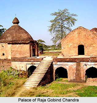 History of Cachar District talks about a number of chronological changes behind the formation of this district of Assam. It recollects that the last of the Kachari Kings, Raja Gobind Chandra was assassinated by a group of rebellious persons with the help of some of his personal attendants on April 24th, 1830 at Haritikar. In the absence of natural heirs, his territory lapsed to the British under the terms of an agreement executed in 1826. T. Fisher, as army officer was sent to take charge of the territory with the power of a collector and magistrate and he took over the entire charge on June 30th, 1830 with headquarters at Cherrapunji.
In the year 1833, the headquarters were shifted to Dudpatil and then to Silchar. The plain portion of the Cachar was formally seized by the British dominion on August 14th, 1832 by a decree of the Governor General in council. Further, T. Fisher was appointed as the first post of the Superintendent of this district. After his death, Messers I.G. Burns, E.R. Lyons, E.S. Person, P.G. Vener and others, succeeded his charges respectively.
As per the historical recounts associated with Cachar District, in the year 1854 North Cachar was annexed to the British Dominion after the death of Senapati Tularam. Again, in 1874, Cachar was included under the authority of the Chief Commissioner of Assam according to the proclamation of 6th February 1874 and the post of Superintendent was re-designated as Deputy Commissioner. R. Stuart was the first Deputy Commissioner of the District. Hailakandi Sub-Division was formed on June 1st, 1869. After the partition of India in 1947, four police stations of former Karimganj sub-division of Sylhet District were transferred to Cachar District.
History of Cachar District talks about a number of chronological changes behind the formation of this district of Assam. It recollects that the last of the Kachari Kings, Raja Gobind Chandra was assassinated by a group of rebellious persons with the help of some of his personal attendants on April 24th, 1830 at Haritikar. In the absence of natural heirs, his territory lapsed to the British under the terms of an agreement executed in 1826. T. Fisher, as army officer was sent to take charge of the territory with the power of a collector and magistrate and he took over the entire charge on June 30th, 1830 with headquarters at Cherrapunji.
In the year 1833, the headquarters were shifted to Dudpatil and then to Silchar. The plain portion of the Cachar was formally seized by the British dominion on August 14th, 1832 by a decree of the Governor General in council. Further, T. Fisher was appointed as the first post of the Superintendent of this district. After his death, Messers I.G. Burns, E.R. Lyons, E.S. Person, P.G. Vener and others, succeeded his charges respectively.
As per the historical recounts associated with Cachar District, in the year 1854 North Cachar was annexed to the British Dominion after the death of Senapati Tularam. Again, in 1874, Cachar was included under the authority of the Chief Commissioner of Assam according to the proclamation of 6th February 1874 and the post of Superintendent was re-designated as Deputy Commissioner. R. Stuart was the first Deputy Commissioner of the District. Hailakandi Sub-Division was formed on June 1st, 1869. After the partition of India in 1947, four police stations of former Karimganj sub-division of Sylhet District were transferred to Cachar District.
The Cachar District is located in the Southernmost part of Assam is one of the oldest district of Assam. The British created it in the year 1830 after the annexation of Kachari Kingdom. In 1854, North Cachar was annexed and tagged to the district. In 1951, the erstwhile North Cachar sub-division was made a separate district and taken out of Cachar District. Further in the year 1983, previous Karimganj sub-division and in 1989, Hailakandi District sub-division was made a separate District.
Moreover, the history of Cachar District also suggests that there are two possibilities regarding the origin of the name of this district. These are - firstly, the Kacharis gave this name Cachar when they ruled this land and secondly, the word Kachar in Sylheti means a stretch of land at the foot of a mountain. Thus, it is assumed that the Bengali people of Sylhet might have given the name Cachar as the land is surrounded by several mountains.
The available historical accounts in connection with the Cachar District also specify the interesting circumstance under which the Kacharis came and ruled this land. It states that in December of the year 1706, the most powerful Ahom king Rudra Singha invaded the Kachari King Tamradhaja, whose capital was at Maibong on the bank of the Mahur River. Being defeated by the Ahom King, Tamradhaja fled southwards to Khaspur. From this time onwards the Kachari prince seemed to have settled in the plains of Cachar, their court being located at Khaspur. Further, the first connection of British with this district dates back to 1762. The next historical event of importance associated with Cachar District recounts the formal conversion of King Krishna Chandra to Hinduism in 1770. Marjit Singha of Manipur with the help of the Burmese drove a few years later last prince Gobinda Chandra from his throne. Afterwards the Burmese drove Marjit Singha from this place to Surma Valley. But the British Government which was in possession of Sylhet expelled the Burmese and handed back the district to Gobinda Chandra. In return, he was required to pay an annual tribute of Rs.10, 000. The king then shifted his abode to Haritikar, but in the year 1830, he was assassinated. In the absence of a natural heir, this territory lapsed to the British Government under the term of a treaty executed in the year 1826. Finally, the Cachar District was formally annexed by the proclamation of August 14th, 1832.
Geography of Cachar District
Geographically, Cachar District is not situated in an advantageous position but strategically, this district is considered as important. Cachar District is the gateway to the neighbouring state of Mizoram and also to the western parts of Manipur and is principally surrounded by hills in all the three sides. Cachar District is located at a longitude of 92 degrees 24 minutes east and 93 degrees 15 minutes east and latitude of 24 degrees 22 minutes north and 25 degrees 8 minutes north.
Demography of Cachar District
According to the Population Census in the year 2011, Cachar had population of 1,736,319. Out of which the male and female were 886,616 and 849,703 respectively. The population of Cachar District constituted 5.57 percent of total population of Assam. The population density of Cachar district is 459 people per sq. km. Cachar district administers 3,786 square kilometres of areas. The average literacy rate of Cachar District is 80.36 percent. According to the gender classification, the male and female literacy were 85.85 percent and 74.62 percent respectively. The total literates in Cachar District were 1,196,892. Out of which the males and females were 652,827 and 544,065 respectively. Concerning about the Sex Ratio in Cachar District, it stood at 958 per 1000 male compared to 2001-census figure of 945. The average national sex ratio in India is 940 as per latest reports of Census 2011 Directorate. In 2011 census, child sex ratio is 955 girls per 1000 boys compared to figure of 961 girls per 1000 boys of 2001 census data.
Tourism in Cachar District
 Tourism in Cachar District in Assam gives the visitors the comfort in inner eyes, as the general natural appearance of this district is extremely picturesque. Cachar district is a heterogeneous land composed of high hills, low lands and level plains. On the north, east and south it is shut by series of purple hills whose forest-clad sides are seamed with beautiful landscapes.
The Silchar sub-division includes the southern section of the Assam range and a belt of hilly country with an average width of six to seven miles, containing peaks between three to four thousand feet in height. The Bhuban Hills range on the eastern frontier covers a considerable area, and rises in places to over 3000 feet above the level of the sea. Almost the whole of the country north and south of the Barak River is dotted with low-ranged isolated hills called "tilahs" rising from the level of alluvial soil. Most parts of the banks of the Barak River are lined with small and beautiful villages concealed in groves of slender areca palms, broad-leaved plantains and feathery bamboos, and in all seasons of the year, the country looks fresh and green. The hills on the southern part of this district are covered with dense evergreen forest and bamboo jungle. Except the natural beauty, there are other tourist attractions are:
Shri Sidheswar Shiva Temple : There is an old shrine at Badarpurghat on the bank of Barak River. This temple is situated at about 200 meters to the east of the Badarpurghat railway station. This old "Shrine", dedicated to the Supreme God of Hindu Religion "Lord Shiva". This temple was built on an old rock. In this holy place, the image of Lord Shiva in the form of a lingam and some other deities are placed and people from all the place come and pay their homage to this Hindu God. The main lingam of the temple was made of stone and was installed in the days of yore by a saint named Kapila, Indian Ancient Philosopher. Every year on the occasion of Baruni, thousands of people gather there for the purpose of congregation. This gathering is known as "Baruni Mela.
Narsingha Akhra : There is an old temple established at Tullapatty (Silchar town) perhaps in about 1846 AD by a Sadhu named Bhagwan Das Ramayati hailing from Ayodhya . Many devotees visit this "Akhra" everyday.
Bhairab-Bari : Bhairab-Bari is located about 20 kms from Silchar west of Lakipur. There is a shrine of Lord Shiva on a hillock about 50 meters high- known as Bhairab Bari. The installation is ascribed to King Lakshmi Chandra
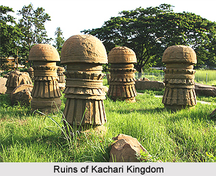
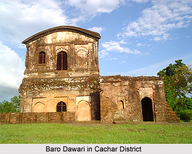
Khaspur : Khaspur is the last Capital of Kachari Kings. The Kachari Kingdom was established by Tamradwaj Narayan about 1690 AD is situated about 24 kilometres north-east of Silchar on the way to the Kumbhirgram Airport. Being a large area it contains the ruins of a brick built two storied palace, the Temple of Ranachandi, Lord Vishnu temple, the ancient brick walls, ancient water tanks etc.
Bharambaba Temple : Bharambaba Temple is situated at Silkuri grant. This is located at a distance of about 18 kilometres from Silchar , on the way to Hailakandi. The two stone images of Lord Brahma and Lord Lakhinarayan are placed there in the temple. A large number of people gather in the temple on Rash Purnima and Magha Purnima every year.
Lord Shiva Mandir : Lord Shiva Mandir is 35 km from the township of Silchar is the famous Shiva Mandir. It is situated on the top of Bhuban Hills. The temple is a renowned tourist spot of the region, where pilgrims and devotes from all over the state come to offer their prayers and seek the blessings of the Lord. Inside the main sanctum of the temple are the idols of Lord Shiva and Goddesses Parvati. From Silchar, it is quite easy to visit the place, as daily buses operate to the base of the hill, from where the remaining distance can be covered on foot.
Kanchakanti Kali Mandir : Kanchakanti Kali Mandir is just 15 km from Silchar, on the way to the Kumbhirgram airport, is situated the famed Kanchakanti Kali temple. This temple is famous for the union of Goddess Durga and Goddess Kali. According to the Hindu Mythology, once the ancient king of the region had a dream, in which he was asked to build an idol of the four-armed goddess. Following his dreams, he constructed the temple and prepared a gold idol of the Goddess, somewhere during 1806. This temple however, got destroyed due to earthquake and the landslides and a new temple was constructed later. It is often said that one`s desires and wishes are fulfilled, if one prays to the Goddess of the temple and as such, devotees and worshippers always crowd the region.
Maniharan Tunnel : Maniharan Tunnel is situated around 5 kilometres to the north of Bhubaneswar temple, in the Bhuvan hills. There also lies the famous Maniharan temple. According to the legends, Lord Krishna used this tunnel during his visit to the region. Just underneath this tunnel, the holy Tribeni River flows and people often come here to bathe in the waters of the river and seek the blessings of the Lord Krishna. A number of festivals, like Holi, Shivaratri and Baruni, are held here every year, where devotees from all over Assam and also the adjacent areas come to offer their prayers. A fun fair is also held in the grounds of the temple, during Dol Purnima or the Holi festival.
Palace of Kachari Kings : The palace of the Kachari kings is situated at a distance of about 10 km from Silchar. The Kachari dynasty was a mighty and powerful dynasty, belonging to the Bodo Tribe-Kachari ethnic group. The archaeological remnants of this strong and advance kingdom still lie in Khaspur, which was their last capital.
Martyr`s Tomb : Martyr`s Tomb is located at Gandhi Bag, on the banks of a lake, are the 11 tombs of the martyrs who dedicated their lives fighting for the language movement of Assam, in 1964. This place is a must-visit for the Bengalis, as the language movement was primarily fought to make Bengali the official language of the Cachar district of Assam. Near the Martyr`s Tomb, there are the other tourist attraction sites like Harishava and the temple of Goddess Lakshmi Devi.
Recently updated articles in States of India

Bandare Waterfalls, Meghalaya
Bandare Waterfalls in South Garo Hills, Meghalaya, is a secluded natural attraction surrounded by dense subtropical forests and rugged mountain terrai...

History of Thissur District
Early History of Thissur District explains flourishing of the port cities. Now these port cities are transformed into archaeological sites.

Tippi Orchid Research Centre, Arunachal Pradesh
Tippi Orchid Research Centre in Arunachal Pradesh is renowned for its rich collection of exotic and endangered orchids. Surrounded by lush rainforest...

Tourism in Nashik District
Pilgrimage tourism in Nashik district involves visiting the various places of Hindu and Jain worship located here. Some of the holiest sites for Hind...

Mangadu, Kerala
Mangadu in Kerala’s Kollam district is a significant megalithic site known for its urn burials, cist burials, menhirs, and stone circles. Excavations...
Related articles in States of India

East Indian States
East Indian States comprises of Bihar, Jharkhand, West Bengal, Odisha and also the Union Territory of Andaman and Nicobar Islands. It defines the cult...

Purnia District in Bihar
Purnia District is located in Bihar and extends from River Ganga to Nepal. The district has a rich Hindu history and glorious past.

Hooghly district
Hooghly District along the bank of the river Hooghly is one of the principal trading ports of West Bengal.

Geography Of Chittoor District
Geography of Chittoor district is spread along the topography of the land which is divided into two natural divisions; Chittoor has a dry and healthy...

Districts of West Bihar
Districts of West Bihar is comprised of medieval monuments that were built by the different governors of Mughal era.