
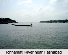
 Hasnabad is a community development block and the town of West Bengal. It forms an administrative division in Basirhat subdivision of North 24 Parganas district in West Bengal.
Location of Hasnabad
Hasnabad is located at 22 degree 34 minutes North to 88 degree 55 minutes East.
Geography of Hasnabad
Hasnabad CD Block is bounded by Basirhat I CD Block in the north, Debhata Upazila in Satkhira District of Bangladesh in the east, Hingalganj CD Block in the south and Sandeshkhali I and Minakhan CD Blocks in the west. Hasnabad CD Block has an area of 155.44 square kilometres.
Landforms of Hasnabad
North 24 Parganas district is part of the Gangetic delta, lying east of the Hooghly River. Hasnabad is flat landforms. It is little raised above flood level and the highest ground borders the river channels. The rivers in the district were formerly distributaries of the Ganges but their mouths have long been filled up and blocked. The area is described as a sort of a drowned land broken by swamps.
Extension of Hasnabad
Hasnabad in the north-east of the district is higher than that of the rest of the districts. The sturdy peasants raise crops of rice, jute and sugarcane from the alluvial soil. There are clumps of palm and fruit trees in which village homesteads nestle. Industrial activity is concentrated in the narrow strip of land along the Hooghly River. The south-eastern part of the district gradually merges into the Sundarbans Mangrove Forest in India. Parts of the metropolitan city of Kolkata extend over southern part of the district.
Sundarbans Area in Hasnabad
Sundarban Mangrove Forest is flat lowland susceptible to the tidal waves along the 260 km shoreline of the Bay of Bengal. The total expanse of Sundarban Mangrove Forest is about 2.05 million hectares (8,000 square miles). Of this, only 0.42 million hectares (1,629 square miles or 10, 43,000 acres) are under the reserve forests including about 0.19 million hectares covered by creeks and channels. The area is prone to natural calamities such as cyclones, thunderstorms with occasional hail and floods. There are more than 63,400 km of embankments but the floods caused by high tidal bores, often wash away much of the embankments, already weakened and broken by earlier cyclonic storms. This area is one of the major revenue earners from Machranga Dwip and Taki.
Related Articles
Kolkata
West Bengal
History of Kolkata
Culture of Kolkata
Monuments in Kolkata
Districts of West Bengal
North 24 Parganas District









