
 The district of Sirohi is situated in the south-western part of the district of Rajasthan. It lies between the parallels of 24 degrees 20 minutes and 25 degrees 17 minutes North Latitude and 72 degrees 16 minutes and 73 degrees 10 minutes East Longitude. It has an area of 5139 kms (2009 sq. miles) and is the third smallest district of Rajasthan after Dungarpur and Banswara. It covers about 1.52 percent of the total area of Rajasthan. Sirohi is bounded by Pali district in the north-east, Udaipur district in east, Jalore district in the west and Banaskantha district of Gujarat in the south.
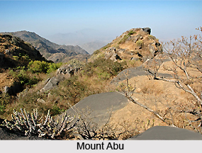
The district is in the shape of an irregular triangle, with the apex near the village of Harji in the extreme north and the base extending west by north-west from a point where the territories of the former states of Sirohi, Idar and Danta met. It is greatly broken up by hills and rocky ranges. The main feature is the almost isolated mountain of Abu, the highest peak of which, Guru Sikhar, rises 5,650 feet (1,722m.) above the sea level. The mountain is situated near the southern border. It is separated by a narrow pass from an adjacent range of narrow hills which runs in a north-easterly direction almost as far as Sheoganj, and divides the district into two almost equal parts. Most of the area of the tehsils of Reodar, Sirohi and Sheoganj lies in the western part of these hills.
The district has on the whole, a dry climate with the hot season somewhat milder than in the adjoining districts to the north and north-west. The cold season starts from November to February. January is the coldest month of the year. During January, maximum temperature is around 25 degree Celsius and the minimum temperature is 10 degree Celsius. In Mount Abu average maximum temperature is around 18.8 degree Celsius. This is followed by the hot season which lasts till about the middle of the June. The period from mid-June to mid-September is the south-west monsoon season; mid-September to the end of November constitutes the post monsoon season. The temperature in winter varies between a maximum of 23 degree Celsius to a minimum of 8 degree Celsius. The temperature increases continuously in the month of March. May and June are considered to the hottest months. During these months the highest temperature is around 47 degree Celsius. Humidity is generally high in the brief south-west monsoon season. During the rest of the year the air is dry.
The major rivers flowing through the district are Jawai, Sukhadi, Khari, Bodi, Krishnavati, Kapalganga, and the Banas River. The main dams of the district are Banas, Oda, Danta, Chandela, Girwar, Niboda, Javal, KarodiDwaj, Angor etc. The district is mainly agricultural, and the major crops grown here are millets, pulses, sesame and red chillies. Languages spoken in the district are Hindi and the Rajasthani language.









