
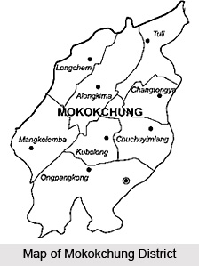
 Mokokchung District, an administrative district of Nagaland, is the home of the Ao Naga tribe. Mokokchung town is the district headquarters. This district covers an area of 1,615 sq kms. Mokokchung District lies between 93.53 and 94.53 degrees longitude and 25.56 degrees latitude. It is bounded by Assam in its north, Wokha District in its west, Tuensang District in its east, and Zunheboto District in its south. As per Census 2001, total population of Mokokchung District is 2,27,230 and literacy rate is 84.27 percent.
Mokokchung District
Mokokchung District is one of the 11 administrative districts of Nagaland. This district has its headquarters at Mokokchung town. The main inhabitant of Mokokchung District is Ao Naga Tribe.
Introduction
Mokokchung District, an administrative district of Nagaland, is the home of the Ao Naga tribe. Mokokchung town is the district headquarters. This district covers an area of 1,615 sq kms. Mokokchung District lies between 93.53 and 94.53 degrees longitude and 25.56 degrees latitude. It is bounded by Assam in its north, Wokha District in its west, Tuensang District in its east, and Zunheboto District in its south. As per Census 2001, total population of Mokokchung District is 2,27,230 and literacy rate is 84.27 percent.Geography of Mokokchung District
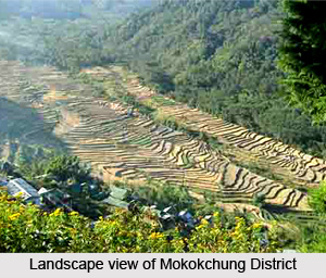 Geography of Mokokchung District is the exploration of the several mountainous regions and the flowing rivers and the green vegetation all around. Mokokchung District is bounded by the state of Assam to its north, Tuensang to its east, Zunheboto to its south and Wokha and Assam to its west, and lies between 93.53 and 94.53 Degrees Longitude and 25.56 Degrees Latitude.
There are several Ranges that run more or less parallel to each other in North-east or South-west direction. Between the Ranges, there are glens and gorges through which flow the hill streams. There are only two small valleys namely Changki and Tuli, and both of them are on the western side of the district adjoining the plains of the Sibsagar district of Assam. The entire District of Mokokchung is conveniently sub-divided into Ranges.
Tzurangkong Range is actually pimples of hillocks thrown at random adjoining the plains of Assam mostly along the valley of Dissai River and Jhanzi Rivers just before they flow into the plains of Assam. These hillocks are densely covered with bamboos and the climate of the entire range is warm.
Japukong Range is the outermost Range stretching from North-east to South-west lying to the interior south of Tzurangkong Range. Changkikong Range is a parallel Range east of Japukong Range. Changki village was said to be founded by a man named Changki, and so the Range too was named after him as Changkikong.
Asetkong Range is a Central Range running from east to west but compared to the other ranges, it is the shortest one. This range lies between Melak and Menung rivers, and therefore, it resembles an island. Hence the name thrives to be Asetkong.
Langpangkong Range is the easternmost range skirting along the course of Dikhu River. The river forms a natural boundary line of Mokokchung with Tuensang and Mon districts. This range is spread like a bed and so the name has been aptly given to this range.
Ongpangkong Range is the southernmost range forming an irregular boundary of the Ao area with that of the Lothas and Semas to the south and with the Sangtams to the east. It is called Ongpangkong as the land is higher and cooler than the other ranges and the word has its etymological roots in the term higher.
Culture of Mokokchung District
Culture of Mokokchung District is mainly tribal in nature as this district is mainly inhabited by the Ao Nagas. There are 93 villages of this tribal community on Mokokchung District. The Ao`s belong to three dialectical groups, namely, Chungli, Mongsen and Changki. Other communities have also settled in Mokokchung District. Ao tribe is one of the major tribes of the Naga family.
Major portion of the total area of Mokokchung District is under cultivation. Rice, Maize, Soya Beans, Pea and Mustard are the major crops cultivated in this district of Nagaland.
Major portion of the total area of Mokokchung District is under cultivation. Rice, Maize, Soya Beans, Pea and Mustard are the major crops cultivated in this district of Nagaland.
Recently updated articles in States of India

Bandare Waterfalls, Meghalaya
Bandare Waterfalls in South Garo Hills, Meghalaya, is a secluded natural attraction surrounded by dense subtropical forests and rugged mountain terrai...

History of Thissur District
Early History of Thissur District explains flourishing of the port cities. Now these port cities are transformed into archaeological sites.

Tippi Orchid Research Centre, Arunachal Pradesh
Tippi Orchid Research Centre in Arunachal Pradesh is renowned for its rich collection of exotic and endangered orchids. Surrounded by lush rainforest...

Tourism in Nashik District
Pilgrimage tourism in Nashik district involves visiting the various places of Hindu and Jain worship located here. Some of the holiest sites for Hind...

Mangadu, Kerala
Mangadu in Kerala’s Kollam district is a significant megalithic site known for its urn burials, cist burials, menhirs, and stone circles. Excavations...
Related articles in States of India

East Indian States
East Indian States comprises of Bihar, Jharkhand, West Bengal, Odisha and also the Union Territory of Andaman and Nicobar Islands. It defines the cult...

Purnia District in Bihar
Purnia District is located in Bihar and extends from River Ganga to Nepal. The district has a rich Hindu history and glorious past.

Hooghly district
Hooghly District along the bank of the river Hooghly is one of the principal trading ports of West Bengal.

Geography Of Chittoor District
Geography of Chittoor district is spread along the topography of the land which is divided into two natural divisions; Chittoor has a dry and healthy...

Districts of West Bihar
Districts of West Bihar is comprised of medieval monuments that were built by the different governors of Mughal era.