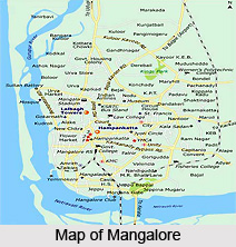
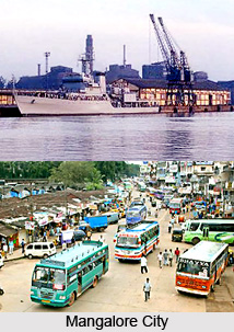
 Mangalore is a city of Karnataka and also the capital of Dakshina Kannada. Mangalore is situated at 12.870 N and 74.880 E of Karnataka. The main attraction of Mangalore is its beaches, temples and industries. This chief port city of Karnataka is located on the west coast of the country on the Arabian Sea and on the east of the city is the Western Ghats. Mangalore is also the administrative headquarters of Dakshina Kannada. The port of Mangalore handles India`s 75% coffee exports and the bulk of its cashew nuts. Mangalore is also the 9th largest cargo handling port of India. As per the World Gazetteer, the estimated population of Mangalore in 2008 is 431,976, which makes it the 101st most populous city in India. The same census depicts that the 50% of the population is male and the 50% are female, which is a nice balance of the genders.
The Mangalore city was named after the local Hindu deity Mangaladevi. The earliest reference of the Mangalore city`s name was made by the Pandya king Chettian. The cosmopolitan nature of Mangalore is hundreds of years old. The languages spoken in the Mangalore are mainly Tulu, Konkani, Kannada and Beary apart from Hindi, Urdu and English. A large group of people of the city follow Hinduism. There is also a sizeable group of people, who follow Jainism.
The landscape of the city is very beautiful with the coconut palms in the rolling hills and streams flowing into the sea. The tiled-roof buildings of the city are made with the popular Mangalore tiles made from the local hard red clay and walled with laterite blocks. The older houses are mainly made of wooden walls.
Mangalore is the trading centre for the state. Even the 1st century travelers knew about the city. The history of the city is hardly known but it is known that the city was once ruled by a tribe named `Alupas`. But Mangalore has been declared as the earthquake prone zone by the Government.
 The visitors` attraction point is the Kerala style Kadri Temple of Mangalore. This temple is designed in modern layout and it has a bronze statue of Lokeshwara, which is famous for being the best bronze of India.
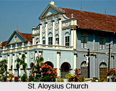
The St Aloysius College chapel of Mangalore is well known for its mural covered walls and ceiling. These were painted by Reverend Antonio Moscheni at the beginning of the 20th century. Rosario Cathedral is another site to visit in Mangalore. It is a large, plain white washed edifice built in 1910. It is said that the dome was modelled on St Peter`s Basilica in Rome.
Mangalore got its name from the temple of `Mangaladevi`, which is situated at a short distance of the cathedral. The three silver doorways of the temple are the most beautiful part of the temple.
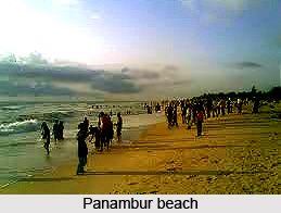
The Mangalore city is surrounded by numerous beaches like Mukka beach, Panambur beach, Tannirbavi beach, KREC beach and Someshwara beach. These are surrounded by coconut trees, palm trees, Ashoka trees along with others. This city is yet very much covered with greenery compared to the other cities of the country. These green beauty of the city can be enjoyed in the Pilikula Nisargadhama, Kadri Park, Tagore Park and in Corporate bank Park.
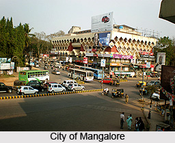
There are lots of malls and shopping complexes in Mangalore. The "Empire Mall" of Mangalore has the Nilgiris supermarket, Coffee Day, Pizza Corner, Dollar store and few other retail chains. The "Bharath Mall" has Adlabs 4 screen Multiplex, Big Bazaar,Food Bazaar, PlanetM, Pizza Hut, Pantaloons, Coffee Day, Subway, Adidas, Reebok, Provogue, Planet Sports, Swawroski, Lewis are few among many others. Spencers, McDonalds, Westside, Reliance Fresh, Landmark, Shoppers Stop have also booked their spaces. This mall will also feature a 6-screen multiplex called `Fun Cinemas`.
The climate of Mangalore is of tropical nature. The average temperature of the city ranges between 270 C to 340 C, which is almost same in both summer and winter seasons. It is very comfortable for the tourists but the humidity is a problem, which reaches up to 78%. The 90% rainfall of the Mangalore city is received within the months of May to October, whereas it remains extremely dry from the month of December to March. The best season to visit the Mangalore city is from September to March month because during this period the humidity and temperature remain lowest.
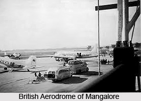
 Mangalore is one of the pleasant and beautiful cities of India. The city is well connected with other districts and many other states of the country. Various transportation means like air, road and rail are available. Mangalore has an international airport located at Bajpe, which is about 30km away from the city. Now, there are daily flights are available for Mumbai, Bangalore, Chennai, Goa, Kochi and Calicut. Whereas, for the international visitors, there are weekly and bi-weekly flights are available for Dubai, Abu Dhabi, Muscat (Oman), Doha (Qatar) and Bahrain. The flights operating from Mangalore comprises Alliance Air, Jet Airways, Kingfisher Airlines, Air Deccan and Air India Express.
There are two big railway stations in Mangalore. The Mangalore station is at Hampankatta, in the heart of the city, which is a terminus. Another station is Kankanady, which is situated about 5 to 10 km from the city. This is on the Konkan railway track and connects Mangalore to Goa and Mumbai in the north and to Kerala in the south. The visitors coming from North Mangalore get down at Surathkal to avoid the traffic between Surathkal and Mangalore. It is a suburb of Mangalore and about 20 kilometers away from the city. From there, bus is available for Mangalore.
The visitors from the nearby states can opt for the bus as the medium of transport. There are two bus stands in Mangalore for long distance services. One is at Bejai, which is the state run KSRTC bus-stand and it is located to the North of the city. From here buses go to Mumbai, Bangalore, Mysore, Goa, Hubli-Dharwad and many other areas within and outside Karnataka. The second bus stand is behind the Town Hall and it is commonly known as the `State Bank` stand.
Another bus stand is also available in front of Milagres Church, where most of the tour and bus operators have their offices. Here buses of semi-deluxe, sleeper and Volvo types to various destinations viz. Mumbai, Bangalore, Goa, Thrissur, and Hubli-Dharwad etc can be found.
 To look around the Mangalore city, the visitors can opt for buses, cabs and auto rickshaws. There are private bus services like Padmambika Bus Co. Ltd, which connect to all other minor centres surrounding Mangalore. Most of them leave from the `State Bank` stand.
The ambassador cabs/Indicas are also available to move around the Mangalore city. Prepaid cabs are also available from the airport to the city, which has a fixed fare of Rs 350 to 400. One can even rent cars in Mangalore to visit the city. So, Mangalore is one of the cities, which is targeted by the tourists to enjoy a holiday.
For complete business listing of Mangalore visit Mangalore Yellowpages
 History of Mangalore deals with the mythological stories of Indian epics, ancient kingdoms of South India, medieval kingdoms of the Muslim Dynasty and the rulers of European colonial eras.
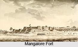 Medieval History of Mangalore
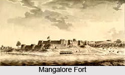
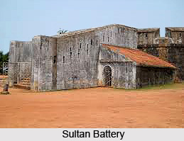
 After tumultuous battle with Haider Ali and Tipu Sultan,
 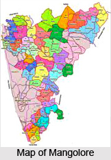 Geography of Mangalore deals with the landforms, rivers and the topography of
 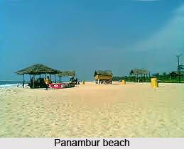 From December to February, the temperatures during the day time ranges below 30 degree Celsius and drop to about 19 degree Celsius at night. This season is soon followed by a hot summer, from March to May, when temperatures rise as high as 38 degree Celsius. The summer gives way to the monsoon season, when the city experiences more precipitation than most urban centres in India, due to the Western Ghats. The rainfall is about 4,000 millimetres. The rains subsided in September, with the occasional rainfall in October.
 Demography of Mangalore or Mangaluru is directly related with its culture and heritages. Mangalore, the city of Mughal and Hindu cultural combination has a population of 484,785. It was recorded according to the 2011 census of India. The sex ratio of Mangalore city, done by the population census is 1014 per 1000 males. The child sex ratio of girls is 930 per 1000 boys.
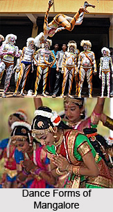 Culture of Mangalore deals with the South Indian dance-drama, dances theatres, and last but not the least is cuisine which are globally famous. The most famous dance-drama in Mangalore and its adjacent area is
 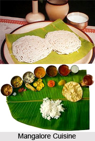 Most of the popular Indian festivals are celebrated in the city, the most important being Dussehra,
 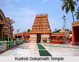 This port city, whose original name was Mangalapura, has been mentioned in 7th century inscriptions. The city, known for its scenic beauty, is situated at the confluence of Netravati and Gurpur rivers. The presence of the religious places provides an aesthetic charm to Mangalore. The city is linked by flights from Bangalore, Mumbai and other important cities. It is well connected by train and bus services as well.
 There are several temples of Mangalore district set on the panorama of palm-fringed beaches, luxuriant green fields and enchanting forests. The temples of Mangalore district are sheltered by the soaring Western Ghats on the east and the mighty Arabian Sea roaring along its western shores.
 Tourism in Mangalore,
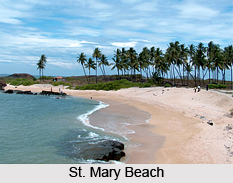
 St. Mary beach is located at a distance of 58 kilometres from the city of Mangalore. The magnificent beach offers an invigorating time to the visitors. Crystallized basalt rocks are scattered over the beach which form another attraction. Due to the rocky terrain, the beach is not favourable for strolling and swimming.
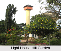 There is an ancient lighthouse in Mangalore which belongs to 18th century and was built by
 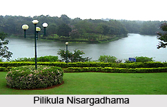 Shri Yogishwar Mutt
 The city also hosts a light house belonging to the 18th century which was constructed by
  Sammilan Shetty`s Butterfly Park is located in Belvai village near Mangalore. It is an open air