
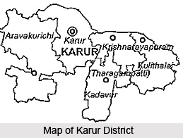
 Geography of Karur district is suitable for the cultivation of various crops and the economy of this district mainly depends on agriculture. This district of Tamil Nadu state has its headquarters at Karur. It is also the most centrally located district of the state of Tamil Nadu. This district is about three hundred and seventy one kilometers to the south-west of Chennai (Madras), the capital of Tamil Nadu. The district of Karur is surrounded by the Namakkal district to the north, Dindigul district to the south, Tiruchirapalli district to the east and the district of Erode to the west.
Up to 44.59 percent of the land area is properly utilized in this district. 4.76 percent of the land area remains as other uncultivated land. 2.74 percent of the area of this district is covered by forest.
 The total use of chemical fertilizers and Bio-fertilizers were twenty thousand four hundred and twenty two tonnes and thirteen thousand pockets respectively. Black soil is the main type of soil found in this district which accounts for 35.51 percent followed by lateritic soil for 23.85 percent. The other types of soil found in this district of Tamil Nadu are sandy and coastal alluvium, which account for 20.31 percent.
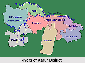
The primary sources of irrigation of the district of Karur are tanks, canals, wells, etc. About 29.71 percent of the total cropped areas are irrigated by these sources. The Karur district is made fertile by the perennial flows of the Kaveri River on the northern side and Amaravati River, Nanganjiyar River and Noyyal River. The highest temperature in this district is obtained in earlier parts of the month of May to early June, usually about 37 degree centigrade, though it normally exceeds 39 degree centigrade for a few days. The average daily temperature of this district in the month of January is around twenty four degree centigrade, though the temperature rarely falls below nineteen degree centigrade. The average annual rainfall of the district of Karur is about six hundred and fifteen mm. The district gets a considerable amount of its seasonal rainfall from the north-east monsoon winds, from the later half of September to mid November.









