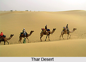
 Jodhpur District is famous for its majestic jewel in the crown of Rajasthan. Jodhpur is a prominent city situated in the Jodhpur district towards the west. From the fringes of the enigmatic Thar Desert, emerges the princely town of Jodhpur. The second largest city of Rajasthan has once remained the capital of erstwhile Marwar state.
Jodhpur District
Jodhpur District is located amidst sand dunes and thorny vegetation and it is the pride of Rajasthan for its leisure tourism and pilgrimage tourism.
Introduction
Jodhpur District is famous for its majestic jewel in the crown of Rajasthan. Jodhpur is a prominent city situated in the Jodhpur district towards the west. From the fringes of the enigmatic Thar Desert, emerges the princely town of Jodhpur. The second largest city of Rajasthan has once remained the capital of erstwhile Marwar state.Location of Jodhpur District
Jodhpur District is surrounded by the majestic Mehrangarh fort, grand palaces, monuments, temples and gardens. Jodhpur is the epitome of multi-faceted grandeur. Tie-dyers, puppet makers and traditional spice makers add to the ethnic flavour of the city.
History of Jodhpur District
 History of Jodhpur district resounds with the glory and valour of the royal dynasties that held sway here. The Rathores have been one of the main ruling families to have held sway over the district. According to Rathore tradition, the clan traces its origins back to the Hindu god, Lord Rama, hero of the epic Ramayana, and thence to the sun. So the Rathore`s belong to the Suryavansha (solar race) branch of the Kshatriya, the warrior caste of Hindus. Later, breaking into historical reality, in 470 A.D. Nayal Pal conquered the kingdom of Kanauj, near modern Kanpur in Uttar Pradesh. The Rathore capital for seven centuries, Kanauj fell in 1193 to the Afghan invaders led by Muhammad Ghori. The fleeing ruler, Jai Chand was drowned in the Ganga River. But his son Siyaji, had better luck. An expedient marriage alliance between the Rathore Siyaji and the sister of a local prince enabled the Rathores to consolidate themselves in this region. In fact, they prospered to such a degree that they managed to oust the Pratiharas of Mandore, nine km to the north of present day Jodhpur.
He later set himself up as an independent ruler around the wealthy trading centre of Pali, just south of Jodhpur. His descendants flourished, battled often, won often, and in 1381 Rao Chanda ousted the Parihars from Mandore which then became the Rathore seat of government. Rathore fortunes then turned for the better. Rao Chanda`s son and heir, Rainmal, won praise for his capture of Ajmer and was then entrusted with the care of his orphaned nephew, destined to inherit the Mewar throne of Chittor. In 1438 Rainmal was doped with opium, and finally shot dead. This triggered bitter feuds, ending with Mewar and Marwar becoming separate states. Rathore legend continues in various versions. One is that Jodha, one of Rainmal`s 24 sons, fled Chittor and finally, 15 years later, recaptured Mandore in 1453. Five years later he was acknowledged as ruler.
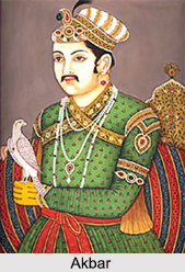
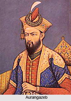 By 1459, it became evident that a more secure headquarters was required. The high rocky ridge nine km to the south of Mandore was an obvious choice for the new city of Jodhpur. It was naturally enhanced by a fortress of staggering proportions, to which Rao Jodha`s successors added over the centuries. Rao Ganga Singh of Jodhpur (reigned 1516-32) fought alongside the army of the great warrior king of Mewar, Rana Sanga, against the first Mughal emperor, Babur. But over the next half century, the rulers of Jodhpur allied themselves with Babur`s grandson, Akbar. Several rulers of Jodhpur became trusted lieutenants of the Mughals, such as Raja Surender, who conquered Gujarat and much of the Deccan for Akbar, and Raja Gaj Singh, who put down the rebellion of the Mughal prince, Khurram, against his father, Jahangir. With the support of the Mughals, the court of Jodhpur flourished and the kingdom became a great centre of the arts and culture. In the 17th century Jodhpur became a flourishing centre of trade for the camel caravans moving from Central Asia to the parts of Gujarat and vice versa. In 1657, however, Maharaja Jaswant Singh (reigned 1638-78) backed the wrong prince in the great war of succession to the Mughal throne. He was in power for almost twenty-five years with Aurangzeb before he was sent out to the frontier as viceroy in Afghanistan. Aurangzeb then tried to seize his infant son, but loyal retainers smuggled the little prince out of his clutches, hidden, they say, in a basket of sweets.
The kingdom of Jodhpur then formed a triple alliance with Udaipur and Jaipur, which together threw off the Mughal yoke. As a result, the maharajas of Jodhpur finally regained the privilege of marrying Udaipur princesses something they had forfeited when they had allied themselves with the rulers of the Mughal dynasty. A condition of these marriages, however, was that the sons born of the Udaipur princesses would be first in line to the Jodhpur throne. This soon led to considerable jealousy. Nearly a century of turmoil followed.
In the 1870`s, Sir Pratap Singh came to the helm of affairs. He was a son of the Maharaja of Jodhpur. He himself ruled a neighbouring kingdom called Idar, and abdicated it to become Regent of Jodhpur, which he ruled, in effect, for nearly fifty years. Sir Pratap Singh was a great warrior and the epitome of Rajput chivalry. Sir Pratap Singh laid the foundation of a modern state in Jodhpur, which Maharaja Umaid Singh (reigned from 1918-47) built upon. The kingdom of Jodhpur was not merely the largest of the Rajput states, but also one of the most progressive.
In 1949, after the independence of India, it was merged into the newly created state of Rajasthan.
Geography of Jodhpur District
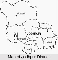
 Jodhpur district is among the largest districts in the state of Rajasthan. It is centrally situated in the western region of the state, and covers a total geographical area of 22850 Sq. kilometres Jodhpur district lies between 26 degrees 0 minutes and 27 degrees 37 minutes north latitude and 72 degrees 55 minutes and 73 degrees 52 minutes east longitude. It is bounded by Nagaur in the east, Jaisalmer in the west, Bikaner in the north and Barmer and Pali in the South. The total length of the district from north to south is about 197 Kms and from east to west it is about 208 Kms. The district of Jodhpur lies at a height of 250-300 metres above sea level.
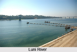
This district comes under the arid zone of the Rajasthan state. It covers 11.60 percent of the total area of arid zone of the state. Some of the area of the great Thar Desert in India also comes within the district. General slope of the terrain is towards west. Extreme heat in summer and cold in winter is the characteristic of the desert. Jodhpur is no exception. The temperature varies from 49 degrees in summer to 1 degree in winter. The Sandstorm (andhi) is a spectacle for people from other regions of India. The rainy days are limited to a maximum of 15 in a year. The average rainfall is 302 mm. There is no perennial river in the district. However, there are important rivers in the district viz. Luni River and Mithri River though their base is saline water. Main sources of irrigation besides rainwater are dug-wells and tube-wells. The highest-irrigated area in the district is in Bilara Tehsil followed by Bhoplgarh and Osian tehsil.
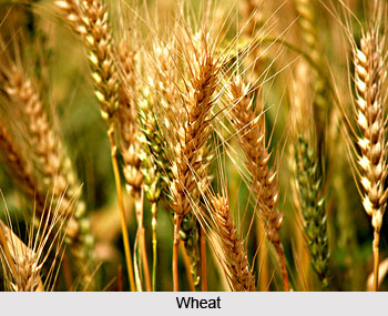
The soil of the district is classified mainly as sandy and loamy. Bajra (pearl millet) is the major crop in the Kharif season. Jodhpur has excellent ground water in many parts of the district. In Rabi, wheat, pulses and a variety of spices like jeera, dhania and red chilli are also grown. Jodhpur is well known for its red chilli, onion and garlic. It is one of the major production centres for Guar. The major and important minerals of the district are sandstone and limestone. Fawn and red coloured sandstone of the district is very popular and found in abundance. Besides this, building stones, stone slabs and flagstones are mined in the district on a regular basis. Minerals like quartz and clays of various colours and dolomite are also available in the district.
On account of the arid climate, a rather negligible percentage of the total reporting area for the land use in the district is covered by forests. Due to sandy soil only scrub and thorny bushes of vegetation are found in the forest areas of the district. The main species of trees are Kumat, Kair, Khejri, Babul, Bir, Jal khara, Pilu etc. Fruit bearing trees are pomegranates and guavas. The fauna of the district includes jackal, Jungle Cat, Indian Fox, Black Buck, Chinkara, common hare, etc. The birds commonly found are Baya, koyal, parrot, Vulture, Jungle Crow, bulbul, House Sparrow, Kite, Sand Grouse, Common quail, grey partridge, little egrit, etc.
Economy of Jodhpur District
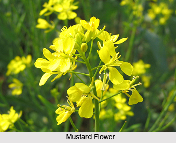 Economy of Jodhpur district can be better clearly understood by taking a look at the agricultural and political scenario in the district. As regards agriculture, out of the total area of 2256405 hectares (village records), 62.53 percent is the total area under cultivation. Among the major crops grown here maize, guar, bajra, moth, moong, chanwla, till, groundnut, chilli, cotton, wheat, barley, chana, isabgol, rap (sarso), mustard, taramira. The major portion of irrigation in the district is carried out by wells. There is a single river, the Luni River, which flows seasonally through the district. Since the district falls under the arid zone of the state, and on account of the non-availability of adequate water, the cropping pattern is by and large single.
 On account of its location and availability of better infrastructural facilities, industrial growth is noticeable in the district. It is centrally located and is one of the important cities of the state. It is well connected with Ahmedabad, Lucknow, Delhi, Mumbai and other important towns of Rajasthan. A sizeable number of engineering industries have been set up in the district. There are other industrial units engaged in manufacture of cement, industrial gases, textiles, derivatives of Gaur Gum, Chemicals, Plastics, electronics, electrical, mineral based, S.S. utensils etc. There are also found a number of rolling mills engaged in processing of stainless steel Sheets or Patta. There are large number of handicraft units engaged in production of items of white metal, wooden toys, fancy items of sheep and decoration. A large number of artisan based industries are engaged in screen printing of cloth, shoe embroidery, dyeing and printing of clothes, salt making, etc. The predominant artisan based industries relate to textile and leather work and units based on livestock. The major activities of artisans in the district are as follows: dyeing and printing of textiles, leather embroidery, wooden carving, white metal work, decorative stone carving, hand paintings, metallic carving, sword handles and ivory carvings, lac bangles and toys of plaster.
There are 21 Industrial Areas at different places which have been developed and managed by RIICO. An export promotion industrial park has been setup in the Boranada industrial area, which is in accordance with the scheme of ministry of commerce, Government Of India, which lays emphasis on providing assistance to state governments for establishments of such kind of parks. The park is expected to increase exports from the state, especially Jodhpur.
Education of Jodhpur District
 A number of cottage industries are also present in Jodhpur which includes glass bangles, cutlery carpets and marble products. The handicraft and tourism are the two other flourishing industries of Jodhpur.
Demography of Jodhpur District
The Indian census report published in 2001 states that Jodhpur had a population of 846,408. Males constitute 53% of the population and females account for the remaining 47%. In Jodhpur, 14% of the population is less than six years of age. The average literacy rate of this ancient city is 67% which is higher than the national average literacy rate which is 59.5%. Out of it, the male literacy rate is 67% and the female literacy rate is 58%.
Culture of Jodhpur District
Jodhpuri cuisine also offers certain mouth watering delicacies which are a bonus for those visiting Jodhpur. Some sumptuous meals include Pyaaj kachori, Mawa Kachori, Makhaniya Lassi, kachar mircha curry and many more. The folk music, the fairs and festivals and the flamboyant costumes of the people lends vibrancy to the city. Numerous festivities of Jodhpur marks the historic grandeur of the city and one such festival is the Marwar Festival. Shopping in Jodhpur can be a memorable experience where exclusive tie and dye fabric, embroidered jutis, velvet can be picked.
Administration of Jodhpur District
 Administration of Jodhpur district is carried out by the District Collector. The office of the Divisional Commissioner is situated in the campus of the District Collectorate of Jodhpur. Jodhpur is the largest division of Rajasthan which comprises of six districts- Jodhpur, Jaisalmer, Barmer, Pali, Sirohi and Jalore. Jodhpur is the largest district (in terms of population) of the Division and administrative control and monitoring of this division is carried out mainly from here only. As has already been stated, District Magistrate and Collector is the head of District Administration. He is assisted by four Additional District Magistrates- Additional District Magistrate-I; Additional District Magistrate-II; Additional District Magistrate-City and Additional District Magistrate-Land Conversion. Along with 4 Additional District Magistrates, there is also one (Development) who is also a project director, DRDA and CEO, Zila Parishad.
For the purposes of administration and development, the district is divided into five sub-divisions, namely, Jodhpur, Pipar City, Shergarh, Osian and Phalodi and seven tehsils, i.e., Jodhpur, Osian, Phalodi, Bilara, Bhopalgarh, Luni and Shergarh. The developmental activities of the district are being looked after by nine Panchayat Samities, i.e. Mandore, Luni, Osian, Bap, Phalodi, Shergarh, Balesar, Bhopalgarh and Bilara. There 1080 villages and 339 panchayats. There is seen a further division into 4 independent upa-tehsils for better administration. These are Baleswar, Bap, Jhanwar and Tinwari.
There is one Municipal Corporation for Jodhpur city and three Municipal Councils at Bilara, Pipar and Phalodi. The Municipal council came into existence in the year 1874 and it was called Municipal Council in those days. The state of Rajasthan has 3 categories of municipal bodies according to the size of the towns. Smallest towns have municipal boards, medium towns have municipal council, and 3 big cities viz. Jaipur, Jodhpur and Kota have municipal corporations. The Municipal Corporation has 60 elected members known as corporators (ward members) representing their respective wards (60 geographical units of the city). The ward members are elected by direct voting by ward-wise electorate for a period of 5 years. In addition to these 60 directly elected members the corporation has 4 Ex-officio members (1 Member of Parliament, 3 members of legislative assembly namely Sardarpura, Soorsagar, City) and 3 Nominated Members.
Rural India, which accounts for nearly three fourths of the India`s population, is characterized by low income levels which are inadequate to ensure a quality of life compatible with physical well being of common man. Rural Development and Panchayati Raj Department in accordance with the policies of the Central and State governments, is responsible at the grassroots for launching a frontal attack on rural poverty through various programmes which endeavour to reach out to the last and most disadvantaged sections of society, provide them with avenues of employment and to improve infrastructure relating to their life-supporting systems. The agency of the Zila Parishad of Jodhpur was registered with cooperative department vide registration certificate no. 147/74-75 dated 10-10-74. Earlier the name of DRDA was District Development Agency (DDA). But as per the order of state Govt. no. F3 (31) agriculture/12/80 dated 17-03-91 the name was changed to District Rural Development Agency. After that, by another order no. F16 (5) DS/Group 1/95 Jaipur dated 14-01-1991, DRDA was reorganised and under that Zila Pramukh of Zila Parishad has been made Chairman of DRDA and District Collector Executive Director. This order has become effective from 6-02-99. DRDA has its own building in the Collectorate Campus.
At the district level the Zila Parishad is responsible for the implementation of the rural development programmes. The governing body of the Zila Parishad includes the Members of Parliament (MPs), Members of Legislative Assembly (MLAs), district level officials of related departments, and representatives of the weaker sections of the society. At the block level the Block Development Officer and at the village level, the Gram Sevaks (Village Representatives) are responsible for the implementation of rural development plans. Some of the rural development programs being implemented by the Zila Parishad are Sampoorna Grameen Rojgar Yojana (SGRY), Saansad Sthaniya Kshetra Vikas Karyakram (MP Local Area Development Program) MPLAD, Vidhayak Sthaniya Kshetra Vikas Karyakram (MLA Local Area Development Program) MLALAD, Swarna Jayanti Swarojgaar Yojana (Golden Jubilee Self-employment Scheme) SJSY, Indira Awaas Yojana (IAY), Guru Govalkar Yojana (GGY), National Social Assistance Programme, Desert Development Programme, Combating Desertification Programme and Gram Sarthi among others.
Tourism in Jodhpur District
There are several places of interest around Jodhpur that are worth checking out. These are accessible from the city as numerous local transports are available.
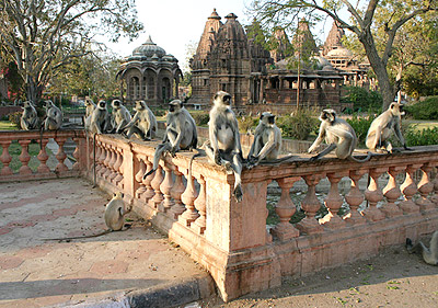 Mandore: This town is well known for its gardens and temples. It is the most oft-visited tourist destination from Jodhpur. It is historically important, as this was the ancient capital of Rajputana. It is located at a distance of 8 kilometers from Jodhpur city. Mandore Gardens, Hall of Heroes, temple of 330 million Gods and the Royal Cenotaphs are the major places of attraction here.
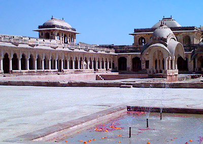
Bal Samand Lake and Palace: Bal Samand Palace in Rajasthan is built on a hillock and faces the Balsammand Lake. It was constructed in 19th century with sandstone. Today it is one of the favorite heritage stays around Jodhpur. Maharajah Sur Singh of Jodhpur, as a summer retreat, built this palace. The lakeside presents remarkable views of the lake.
Sardar Samand Lake and Palace: Located at a distance of 60 kilometers from Jodhpur this is another place that provides the tourists with fabulous scenic beauty. It was constructed by Maharaja Umaid Singh. Its architecture is essentially Rajputana. The lake, in particular, is the abode of migratory birds. It forms a wonderful background for the palace, which has been converted into an accommodation unit in the recent years.
Osian: It is a desert town that is known for its temples. This place presents the splendor of Rajasthan. It is located at a distance of 55 kilometers from Jodhpur city. The main attractions of this place are the gold dunes. The town dates back to 8th century. The exotic sculptures at the Osian temples represent the lifestyle of the people of ancient times.
Dhawa: The Dhawa Wild Life Sanctuary has an exclusive collection of wildlife species. It is located 45 kilometers away from the Jodhpur City. Its distinctive collection of desert rats and antelopes has made it popular amongst the travelers. The largest number of chinkaras or Indian Gazelles is to be found here.
 Nagaur: This desert town is situated around135 kilometers to the northeast of Jodhpur. The city dates back to the 4th century. The main attraction of this place is the Ahhichatragarh Fort. Within the fort premises the visitors will come across palaces, mosques, temples, baolis, water systems, fountains, open terraces and others. The five-domed mosque, built by Akbar, is another attraction of this place.
Achalgarh Fort: This fort is situated in Mount Abu. It was built by Maharana Kumbha in the 14th century. It is well known for Achaleshwar Mahadeo temple too. This also forms one of the major attractions for the hill station as well.
Dargha of Sultan UL Tarkin: This dargah is dedicated to a disciple of Moinuddin Chisti of Ajmer.
Phalodi Khichan: Located 135 kilometers away from the city of Jodhpur it is worth the visit. It is also accessible from Osian. Phalodi is the city of intricately carved havelis and temples while the village of Khichan houses the flocks of Demoiselle cranes. These migratory birds receive a warm welcome and from the village. Several folk songs are based on them.
Manvar: It is a desert resort. Located right at the heart of the desert area it presents a magnificent view of the golden sand dunes. The resort is just the perfect place to stay and enjoy its beauty. This place is a far away cry from the resorts of the Southeast Asian countries. Its unique features make it a must see for the tourists.
Jodhpur Guda Bishnoi Village: It is located at a distance of 25 kilometers from the city of Jodhpur. It is famous for the tribal community of Bishnoi. Located on the banks of Guda Bishnoi, an artificial lake, it presents a picturesque picture to the visitors. This lake is an abode to the migratory birds. The tribal community is quite protective about the wildlife that resides in the adjacent areas. In fact they are staunch worshippers of nature.
Other places of interest around Jodhpur include Amar Singh`s Cenotaph. Besides this there are several temples that are also part of the excursion tours. These are Jain Kaanch ka Mandir and Bansiwale ka Mandir. It is a unique feature in Rajasthan that both the Hindu and Jain temples coexist. This reflects the religious sentiments and the beliefs of the people.
Mandore: This town is well known for its gardens and temples. It is the most oft-visited tourist destination from Jodhpur. It is historically important, as this was the ancient capital of Rajputana. It is located at a distance of 8 kilometers from Jodhpur city. Mandore Gardens, Hall of Heroes, temple of 330 million Gods and the Royal Cenotaphs are the major places of attraction here.
Bal Samand Lake and Palace: Bal Samand Palace in Rajasthan is built on a hillock and faces the Balsammand Lake. It was constructed in 19th century with sandstone. Today it is one of the favorite heritage stays around Jodhpur. Maharajah Sur Singh of Jodhpur, as a summer retreat, built this palace. The lakeside presents remarkable views of the lake.
Sardar Samand Lake and Palace: Located at a distance of 60 kilometers from Jodhpur this is another place that provides the tourists with fabulous scenic beauty. It was constructed by Maharaja Umaid Singh. Its architecture is essentially Rajputana. The lake, in particular, is the abode of migratory birds. It forms a wonderful background for the palace, which has been converted into an accommodation unit in the recent years.
Osian: It is a desert town that is known for its temples. This place presents the splendor of Rajasthan. It is located at a distance of 55 kilometers from Jodhpur city. The main attractions of this place are the gold dunes. The town dates back to 8th century. The exotic sculptures at the Osian temples represent the lifestyle of the people of ancient times.
Dhawa: The Dhawa Wild Life Sanctuary has an exclusive collection of wildlife species. It is located 45 kilometers away from the Jodhpur City. Its distinctive collection of desert rats and antelopes has made it popular amongst the travelers. The largest number of chinkaras or Indian Gazelles is to be found here.
Nagaur: This desert town is situated around135 kilometers to the northeast of Jodhpur. The city dates back to the 4th century. The main attraction of this place is the Ahhichatragarh Fort. Within the fort premises the visitors will come across palaces, mosques, temples, baolis, water systems, fountains, open terraces and others. The five-domed mosque, built by Akbar, is another attraction of this place.
Achalgarh Fort: This fort is situated in Mount Abu. It was built by Maharana Kumbha in the 14th century. It is well known for Achaleshwar Mahadeo temple too. This also forms one of the major attractions for the hill station as well.
Dargha of Sultan UL Tarkin: This dargah is dedicated to a disciple of Moinuddin Chisti of Ajmer.
Phalodi Khichan: Located 135 kilometers away from the city of Jodhpur it is worth the visit. It is also accessible from Osian. Phalodi is the city of intricately carved havelis and temples while the village of Khichan houses the flocks of Demoiselle cranes. These migratory birds receive a warm welcome and from the village. Several folk songs are based on them.
Manvar: It is a desert resort. Located right at the heart of the desert area it presents a magnificent view of the golden sand dunes. The resort is just the perfect place to stay and enjoy its beauty. This place is a far away cry from the resorts of the Southeast Asian countries. Its unique features make it a must see for the tourists.
Jodhpur Guda Bishnoi Village: It is located at a distance of 25 kilometers from the city of Jodhpur. It is famous for the tribal community of Bishnoi. Located on the banks of Guda Bishnoi, an artificial lake, it presents a picturesque picture to the visitors. This lake is an abode to the migratory birds. The tribal community is quite protective about the wildlife that resides in the adjacent areas. In fact they are staunch worshippers of nature.
Other places of interest around Jodhpur include Amar Singh`s Cenotaph. Besides this there are several temples that are also part of the excursion tours. These are Jain Kaanch ka Mandir and Bansiwale ka Mandir. It is a unique feature in Rajasthan that both the Hindu and Jain temples coexist. This reflects the religious sentiments and the beliefs of the people.
Recently updated articles in States of India

History of Thissur District
Early History of Thissur District explains flourishing of the port cities. Now these port cities are transformed into archaeological sites.

Tippi Orchid Research Centre, Arunachal Pradesh
Tippi Orchid Research Centre in Arunachal Pradesh is renowned for its rich collection of exotic and endangered orchids. Surrounded by lush rainforest...

Tourism in Nashik District
Pilgrimage tourism in Nashik district involves visiting the various places of Hindu and Jain worship located here. Some of the holiest sites for Hind...

Mangadu, Kerala
Mangadu in Kerala’s Kollam district is a significant megalithic site known for its urn burials, cist burials, menhirs, and stone circles. Excavations...

Devaswom
History of Devaswom is not very ancient and can be dated back to late seventeenth century.
Related articles in States of India

East Indian States
East Indian States comprises of Bihar, Jharkhand, West Bengal, Odisha and also the Union Territory of Andaman and Nicobar Islands. It defines the cult...

Purnia District in Bihar
Purnia District is located in Bihar and extends from River Ganga to Nepal. The district has a rich Hindu history and glorious past.

Hooghly district
Hooghly District along the bank of the river Hooghly is one of the principal trading ports of West Bengal.

Geography Of Chittoor District
Geography of Chittoor district is spread along the topography of the land which is divided into two natural divisions; Chittoor has a dry and healthy...

Districts of West Bihar
Districts of West Bihar is comprised of medieval monuments that were built by the different governors of Mughal era.