 Geography of Jashpur District is divided into two parts - Upper Ghat and Nichghat. The hilly belt in the northern part, running from Loroghat Kastura, Narayanpur and Bagicha up to the Sarguja District is the upper ghat. This belt has a huge forest area including reserve forests. It covers the Sanna, Bagicha and Narayanpur. Upper ghat is climbed through Loro Ghat. And the remaining southern part is called Nichghat. In Jashpur Raigarh road, there are two more ghats, Jhanda ghat before Kansabel and Belaghat after Kansabel.
The north south length of this district of Chhattisgarh is near about 150 kms, and its east-west breadth is around 85 kms. Its total area is 6,205 sq km. It lies in the northern corner of Chhattisgarh adjoining the border of Bihar, Jharkhand and Orissa in the eastern side. The upper ghat is an extension plateau covering 1384 sq kms, which is about 1200 meters above the sea level and is covered with the dense forest. Geography of Nichghat is plane in general dotted with many big mountains. Kunkuri is the hottest region in Nichghat during the summer season and Pandrapat is the coldest region in Upper ghat in winter season.
Geography of Jashpur District is appositely characterized by deep, dense and extensive forests, a number of rivers and their tributaries and hills. Further, this district is rich with dense and green flora. The northern portion of the district has a long chain of hills and mountains, sometimes running parallel to each other or crossing each other at some point. Further, there are lush green terrains as well as valleys.
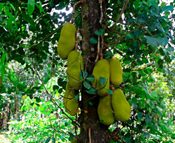
In Ludeg village of Jashpur District huge quantity of tomatoes is planted and the ripe tomatoes are found mainly during October, November, December and January. In the Upper ghat of Jashpur headquarters region jackfruit trees are planted in many numbers. These fruits are found during March, April, May and June. Topography and the soil texture of Jashpur District consist of prosperous bio-diversity and enough mineral deposits. The geographical features also include well distributed drainage system and pleasant climate. Nature has given every thing generously. Some mineral resources are found in Jashpur District such as Bauxite. Manora block area is the belt of bauxite.


