
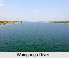
 Gondia is situated in the north-eastern side of the state of Maharashtra, having the state borders of Madhya Pradesh and Chattisgarh. It lies between the north latitudes of 20.39 and 21.38, and the east longitudes of 89.27 to 82.42. The adjoining districts to Gondia are Balaghat district of Madhya Pradesh on the northern side and on eastern side Rajnandgaon district of Chattisgarh state. To the south and west are Chandrapur district and Bhandara district of Maharashtra. The district headquartesr is situated at Gondia lying along the Mumbai- Kolkata railway route which is 1060 Km from Mumbai, the capital of the state. Wainganga River is the largest and most important river. Rivers like Bagh, Chulbandh, Gadhavi and Bavanthadi are the tributaries of river Wainganga.
Gondia district is unique in Maharashtra in the sense that the entire area of the district is occupied by metamorphic rock and alluvium. Alluvium is developed all along the major river courses such as Bagh, Chulbandh and Gadavi. Laterites are distributed all over the district but observed prominently in Arjuni and Arjuni Moregaon. Metamorphic rocks like various granites, Gneiss, Schists, Phylites etc. are exposed throughout district. Gondia district is also rich in economic minerals like manganese, kyonite, sillimanite corundum and pyrophyllite.
Geomorphologically the district can be divided into two parts
1) The north-western, north eastern, south-eastern and central parts which have structural units like hills and ridges.
2) The northern, north-central, west central, south and south-west portions having undulating topography over denudational units like pediments and fluvial units
The major land use categories in district include:
1) Buildup land
2) Agricultural land : which comprises of a) Kharif b) Rabi c) Double crop d) Fallow land
3) Forest Land which includes a) deciduous Forest b) Degraded forest c) Forest blank d) Forest plantation
4) Waste land comprising of- a) Land with or without scrub b) Barren rocky/stony waste.
5) Water bodies which include a) Lakes and reservoirs b) Rivers and streams.
6) Other land comprising of mining area
The largest land use category in the district is that of agriculture. Deciduous forests constitute 90 percent of the total area under forest which is maximum in south east and central parts.









