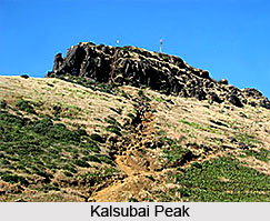
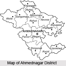
The geography of Ahmednagar District comprises various land forms. There are hilly off-shoots of the Sahyadris in the western part of he district. They are called Kalsubai, Adula, Baleshwar and Harishchandragad hill ranges. Kalsubai, the highest peak in the Sahyadris, lies in Ahmednagar district. Harishchandragad, Ratangad, Kulang and Ajuba are some other peaks in the district. We see the Vita ghat on the way to Randha falls and the Chandanpuri ghat on the Pune-Sangamner road. In the northern part of the district, plains are found along the banks of the rivers Godavari and Pravara and the southern part, along the rivers Bhima, Ghod and Sina.
The different land forms in a region constitute its physical setup. If we consider the physical setup of Ahmednagar district we see that there are three physical divisions:
•* Western Hilly Region
•* Central Plateau Region
•* The region of northern and southern plains
 Western Hilly Region
 : Akole taluka and of Sangamner taluka are included in this region. The hill ranges of Adula, Baleshwar and Harishchandragad lie in this region and various high peaks are found in the same region. Kalsubai of height of 5427 feet, the highest peak in the Sahyadris, lies in this Region.
Central Plateau Region : Parner and Ahmednagar talukas and parts of Sangamner, Shrigonde and Karjat talukas are included in this region.
Region of Northern and Southern Plains : This region includes northern Kopargaon, Rahata, Shrirampur, Rahuri, Newasa, Shevgaon and Pathardi talukas. This is the region of the Godavari and the
Pravara river basins. Parts of the southern talukas of Shrigonda, Karjat, Jamkhed are also included in this physical division. This region covers basins of the Ghod, Bhima and the Sina rivers.
 The district is drained by two chief rivers
 :
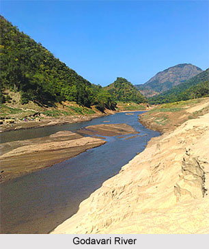
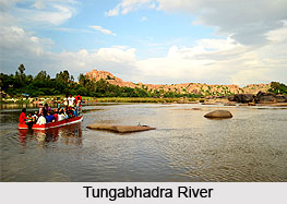
Godavari River and the Bhima a tributary of Krishna River. The Water-shed line is the great spur of the Sahyadris which branches off at Harichandragad and stretches completely across the district from west to east. The important rivers flowing through the district are Paravara, Mula, Sina and Dhora. Pravara is tributary of the river Godavari. Water of the river Pravara falls from a great height, creating the Randha Falls.
The Godavari, which drains by far the larger part of the district, including the tahsils of Kopargaon, Sangamner, Akole, Rahuri, Newasa, Shevgaon the northern half of Parner and parts of Nagar and Jamkhed, rises near Trimbak in Nashik on the eastern slope of the Sahyadris. After passing the
Nashik city it receives the Banganga and the Kadva from the north and Darna from the south and is already a considerable stream, when, after course of about sixty miles, it enters north-west corner of the Kopargaon tahsil. It then flows south-east through rich alluvial plain past Kopargaon to the town of Puntamba, which is situated on the Nizam`s frontier ,where it receives from the south the combined water of Kat and Khara rivers. From Puntamba to a point beyond Paithan, a distance of sixty miles, the Godavari forms almost continuously the boundary between Ahmednagar and the Nizam`s dominions. At the village to Toka it receives on its right bank the combined waters of the Pravara and the Mula. A few miles below, the Shiva and Ganda join it from the left and the Dhora from the right. Two miles east of Mungi the river enters the Nizam`s dominions, and hence, flowing across the peninsula, it empties itself into the
Bay of Bengal after the total course of 900 miles.
The Pravara rises on the eastern slopes of the Sahayadris between Kulang and Ratangad. After the sinuous course of twelve miles in an easterly direction, near the village Ranad, it falls into rocky chasm 200 feet deep and then winds for eight miles through a deep narrow glen which opens wider Valley East of and below the central plateau on which the town of Rajur stands. Total Length of Pravara is 120 miles. The
Bhandardara Dam is constructed across the river at Bhandardara, near by are the Randha falls.
The Adhula rises in north of Akole on the Slopes of Patta and Mahakali. It flows for fifteen miles in an easterly direction between two ranges of hills which encloses the Samsherpur valley; then falling into the rocky chasm some 150 feet deep it winds between rugged and precipitous hill-sides for couple of miles, when, debounching in to the plain of Sangamner, it turns south and falls into the Pravara three miles west of the town of Sangamner.
The Mahalungi rises on the southern and eastern slopes of Patta and Aundha. After the course of three miles it passes east into the Sinnar subdivision of Nashik. It re-enters Ahmednagar after taking bend to south.
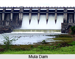
The Mula rises on the eastern slopes of the Sahaydris between Ratangad and Harichandragad. For first twenty miles it flows parallel to Pravara draining the southernmost or Kotul valley of Akole subdivision. Passing the town of Kotul it takes a bend to Baleshvar. It then crosses through Sangamner, Parner. The
Mula Dam is constructed across the river at Baragaon Nandur.
The Dhora rises on the slopes of the hills east of the town of Ahmednagar. It flows in the north-east direction, draining Shevgaon and part of Newasa. The
Bhima River drains the whole of the southern portion of the district, comprising the greater part of the Parner and Nagar subdivisions, the whole Shrigonda and Karjat, and nearly the whole of Jamkhed.
The Sina River has two chief sources, one near Jamgaon fourteen miles west of the town of Ahmednagar, near, Jeur ten miles to the north-east. The town of Ahmednagar is built on left bank of the river, which there takes south-easterly course. Leaving the district boundary it enters Solapur and ultimately merges with Bhima River.
The western hilly part of Ahmednagar district has forests.
Indian Teak tree,
babul, dhavada and
Neem trees are found in these forests. Fruit trees like Mango,
Tamarind, Amla and Bor are also found in the district.
 Ahmednagar District is the largest district in the State of Maharashtra. The district echoes the history of the past. The Ahmednagar fort at Ahmednagar is a place of historical importance. It is at this fort where many of our freedom fighters were detained during the Indian Freedom Movement. It was here that Late Pandit Jawaharlal Nehru was detained during Indian freedom movement and it was at this fort he wrote his famous book "Discovery Of India".
 The early history of Ahmednagar starts from 240B.C. when the vicinity is mentioned in the reference to the Mauryan Emperor
 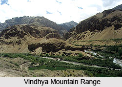 The famous king of Yadav was Ramdeorao. Otherwise strong and brave, the military unpreparedness of the king made face defeat at the hands of Ala-ud-din Khilji, the commander-in-chief of the Mughal king of Delhi at Devgiri in 1294. This was the first ever invasion of the Muslim kings in the South across the
  Bajirao Peshwa was continuously at war with Yeshwantrao Holkar and Daulatrao Sindia. Finally he concluded a treaty with the British for the safety of his Ministership, on 31st December 1802 at Bassein.
 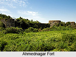 During the
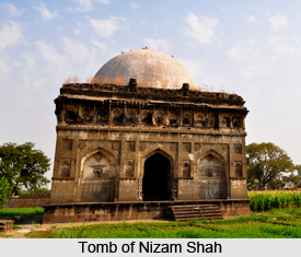
 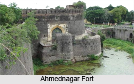 The monuments of Ahmednagar are magnificent constructions mainly built by the rulers of the Nizam Shahi dynasty. The town was founded by Ahmad Nizam Shah in 1494 on the site of an earlier settlement. The
  Religious Monuments of Ahmednagar
 During the reign of Uurhan Nizam Shah, flat -roofed structures with taller minarets emerged as a distinct style. The Mosque of Ghulam Ali, near the Gandhi Maidan, is typical of this, with sleek minarets.