Home > Travel > States of India > Ethipothala Falls
Ethipothala Falls
Ethipothala Falls is a waterfall that allures the nature lovers. This waterfall is located in Andhra Pradesh.

Share this Article:

Ethipothala FallsEthipothala Falls is a natural waterfall located in Andhra Pradesh. This waterfall is situated on the Chnadravanka River, a small tributary of Krishna River.

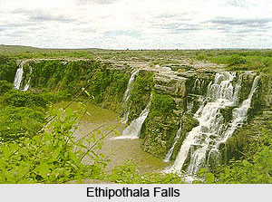
Ethipothala Falls is 70 feet and attracts the tourists of national and international level not only as a nature tourism site, but also the place of leisure tourism.

This 21 meter high river cascade is situated on the Chandravanka River, a rain fed river. This river is a tributary of the Krishna River, which acts as a life line of South India. The waterfall is a combination of three streams namely Chandravanka Vagu, Nakkala Vagu and Tummala Vagu.

Ethipothala Falls is situated about 11 kilometres from Nagarjuna Sagar Dam. Nagarjuna Sagar Dam is the world"s largest dam. It was built on the Krishna River at Nagarjuna Sagar in the border of Nalgonda District and Guntur district of Andhra Pradesh.

Chandravanka River then joins the Krishna River after the dam travelling about 3 kilometres from Ethipothala Falls. A strategic view point was created by Telangana Tourism Department from the adjacent hillock. There are Ranganatha and Dattatreya temples in the vicinity. There is a crocodile breeding centre in the lagoon formed by the Ethipothala Falls.

The name Ethipothala Falls is derived from the legend that is Yathis and Rishis did the penance here. So the place got the name Etitaposthal, which means the place where Yathis did penance. In Sanaskrit language Iti means the Tapas. Here it refers to a personal endeavour of discipline, undertaken to achieve a goal Sthal which means the place.

The word Ethipothala in Telugu Language means lift and pour. So people assume that Ethipothala Falls are part of Lift Irrigation Scheme, a project undertaken by The Government of Telangana. This is also known as Ethipothala Padhakam.

Near Ethipothala Falls, there is a major Irrigation Project which is known as Nagarjuna Sagar Dam. This Nagarjuna Sagar Dam provide electricity and irrigation waters. This gives a scope for people to assume that Ethipothala Falls are part of that project of Nagarjuna Sagar Dam.

Ethipothala Waterfall is also a most interesting place for mild trekking and camping. This waterfall offers the refreshing nature sightseeing. People believe that the caves near the waterfalls go to Srisailam. Ethipothala Falls is bounded on the North by Medak District and Warangal district, on the South by Guntur District and partly by Mahbubnagar district on the East by Khammam District and Krishna district, on the West by Ranga Reddy District and Mahabubnagar district. Near Ethipothala Waterfall, there are some tourist attractions to visit along the regions like Nagarjuna Sagar Dam, Nagarjuna Konda, Anupu, Srisailam, Ranganadha, Sagara Mata and Dattatreya Temples.


Share this Article:

Related Articles

More Articles in States of India


East Indian States
East Indian States comprises of Bihar, Jharkhand, West Bengal, Odisha and also the Union Territory of Andaman and Nicobar Islands. It defines the cultural heritage, rich historical background and the linguistic unity.
Erode District
Erode District is one of the districts in the state of Tamil Nadu. The district of Erode is having a land-locked area with no sea coast.
Purnia District in Bihar
Purnia District is located in Bihar and extends from River Ganga to Nepal. The district has a rich Hindu history and glorious past.
South Delhi District
South Delhi District is the third largest district of Delhi as far as its area is concerned. South Delhi District is known for its economic, historical, cultural and social significance.
North Indian States
North Indian States formed the cultural and religious unity in spite of having many foreign invasion and the political disturbances from the early era till the British gained supremacy in Indian sub continent.
Kendujhar District
Kendujhar District, spread over an area of 8,240 sq kms, is as varied as the whole of Orissa with waterfalls roaring gorges, mountains and minerals. The manifold expressions of nature in Kendujhar District are considered as unique.
Hooghly district
Hooghly District along the bank of the river Hooghly is one of the principal trading ports of West Bengal.
Districts of South Tamil Nadu
Districts of South Tamil Nadu consist of many tourism destinations like archaeological sites and the history of Pandyas and Cholas. Considering their proximity to the sea, many districts also boast of serene beaches and coastal beauty.
Flora of Arunachal Pradesh
Flora of Arunachal Pradesh includes infinite species and is a subject of great interests for the botanists.
Districts of South Gujarat
Districts of South Gujarat are the epicenter of Jain pilgrimages and the early Hindu kingdoms.
North West States of India
North West States of India consist of three states, which are Rajasthan, Punjab and Haryana. All of them are culturally and traditionally diverse and they have been ruled by different dynasties in historical time.
Geography Of Chittoor District
Geography of Chittoor district is spread along the topography of the land which is divided into two natural divisions; Chittoor has a dry and healthy climate.
Districts of North Rajasthan
District of Northern part of Rajasthan is dotted with ancient forts and medieval villages.
Districts of North Odisha
District of North Odisha has Bengal boundary and shares the same culture. These are reachable if one pays a weekend visit to Digha.
Districts of West Bihar
Districts of West Bihar is comprised of medieval monuments that were built by the different governors of Mughal era.
Districts of South Haryana
Districts of South Haryana consists of many cities of industrial excellence. These districts are dotted with popular tourism destinations.
Medieval History of Assam
Medieval history of Assam narrates the advent and rule of a number of kingdoms in the region. The prominent dynasties of the kingdom left an everlasting imprint on the socio cultural heritage of India.
Geography of Meghalaya
The suitable climate, highland plateaus, rivers and the flora and fauna together forms the geography of Meghalaya.
Districts of Rayalaseema
Districts of Rayalaseema in Andhra Pradesh state has urban population and rural settlements as well.
Districts of South Punjab
Districts of Southern part of Punjab depict medieval history of Punjab and the rise of Sikhs.