Introduction
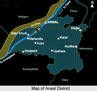
Arwal district is one of the thirty-eight districts of Bihar state. It was earlier part of Jehanabad District. The Arwal town is the administrative headquarters of this district. The district`s headquarter is situated at Arwal which is approximately 80 km south from the state capital Patna. Arwal town is situated on the right side bank of the river Son, which is a tributary to the Ganga River. Arwal district is a part of Magadha division. It came into existence in September 2001 and was earlier part of Jehanabad district. The five block divisions are Arwal, Kaler, Karpi, Kurtha and Suryapur Vanshi.
History of Arwal District
History of Arwal district shows the contribution of the well-known Poet of Sanaskrit language, Banabhatta. He was born here in the village Banshi Suryapur. He is the notable writer of the book named `Harsha Charita` which is a biography of King Harshvardhana, It is believed that the poet Banabhatta, worshiped Budhwa Mahadev Mandir which was erected by himself. It is a commonly believed that Banabhatta used to visit Devkund, which is situated 6 miles south west away from village Banshi.
Village Banshi Suryapur is situated on the right bank of "Aadi Ganga Punah Punah" now known as Punpun River. It is believed that the last `Pind Daan` for the salvation of soul is performed in river Punpun. If a man offers Tarpan in Punpun River, then there is no need to offer a Pinda daan or any holy ritual anywhere else. Even a simple bath in river Punpun gives salvation. Punpun River is older than Ganga river that`s why Punpun is said Aadi Ganga.
Village Pantit is another famous place in Arwal district as the footprint of Lord Vishnu is situated at here. At Pantit, Lord Vishnu had put his leg in His Vamana Avtar. Lord Vishnu begged from King Bali three steps of land. The first leg step was put at Pantit in Arwal district, the second leg step having in the sky and the third one on the head of King Bali at his request.
The Chinese were the first to make paper, from where the technology went to Samarkand. From there it eventually reached India. Soon the Indian paper was being exported to West Asia, Europe and Turkey. Bihar had two major papermaking centres in medieval times. First, was Arwal town and second was Bihar Sharif.
Economy of Arwal District
Education of Arwal District
Arwal has literacy level of 45%. The level of primary and middle education is satisfactory. However, the higher education provided district is not upto the mark. The district has 3 colleges, 39 high schools, 187 middle schools and 282 primary schools under state government of Bihar.


