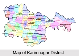
 Administration of Karimnagar district in Telangana is carried out according to the administrative divisions of the state. During the process of re-organisation in 1986, the 14 revenue taluks were divided into 56 mandals. More recently, the Elagiad Mandal has been created by putting together some villages of Sultanabad and some villages of Julapally Mandal. This has increased the total number of mandals to fifty seven. A total of five revenue divisions have been carved out for the district of Karimnagar. These are Karimnagar, Jagtial, Peddapalli, Manthani and Siricilla. In 2014, this district is merged into Telangana, a newly formed state in India with a capital Hyderabad. The district is currently a part of the Red Corridor.
Gram Panchayats of Karimnagar District
Gram Panchayats of Karimnagar District in Telengana form a very important part in the administrative set-up of the district. The jurisdiction of the Gram Panchayats covers the entire District of Karimnagar, excluding the areas of the Municipalities of Karimnagar, Jagtial, Korutla, Siricilla and Notified Area Committee Ramagundam. There are a total of 1195 Gram Panchayats in Karimnagar District out of which 26 are notified and the remaining are Non-Notified. Apart from the five revenue divisions, the district consists of three Panchayat Divisions covering fifty seven Mandal Parishads and 1104 Revenue Villages.
 Divisions-wise the number of Gram Panchayats is as follows. Karimnagar division has a total of eighteen mandals, of which 392 gram panchayats are non-notified and 8 are notified, taking the total number of gram panchayats to 400. In the Jagtial Division, there are a total of twenty three mandals. Contained here are 488 non-notified Gram Panchayats and 14 notified Gram Panchayats, taking the total up to 502. Finally in the Peddappali division, there are a sixteen mandals out of which 290 gram panchayats are non-notified and 4 are notified. The total number of Gram Panchayats found here are 293.
The main source of finance for the Gram Panchayats is taxation. The Gram Panchayats levy all the mandatory taxes, like, property tax, License fee and others. Gram Panchayats are classified according to their income range.
Where Corporations are concerned, there is only one Municipal Corporation and 5 municipalities, i.e., Jagtial, Korutla, Siricilla, Ramagundam and Metpalli. These are enlisted in the map of Karimnagar District as the cities in Telangana. Other gram pamchanyats in this district are Bejjanki, Bheemadevarpalle, Boinpalli, Chandurthi, Chigurumamidi, Choppadandi, Dharmaram, Dharmapuri, Eligedu, Elkathurthi, Ellanthakunta, Gambhiraopet, Gangadhara, Gollapally, Husnabad, Huzurabad, Ibrahimpatnam, Jagtial, Jammikunta, Julapalli, Kalva Srirampur, Kamalapur, Kamanpur, Karimnagar, Kataram, Kathlapur, Kesavapatnam, Kodimial, Koheda, Konaraopeta, Korutla, Mahadevpur, Malhar, Mallapur and many others.


