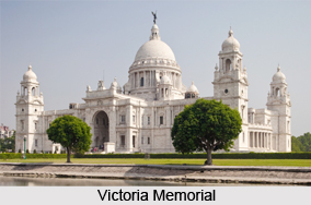
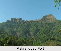
 Located in the midst of the Javali forest, the Makrandgad Fort stands at an altitude of 4,054 ft in the Satara district of the state of Maharashtra. Also known as the Madhu Makrandgad Fort, the Makrandgad Fort is a part of the other various forts in Maharashtra. It is close to the Pratapgad Fort and has two flattened humps with a ridge between them.
History of Makrandgad Fort
Constructed during the same time as the Pratapgad Fort, the Makrandgand Fort was built by the Maratha Emperor Shivaji in 1656. The fort served as a link between the Pratapgad and Vatsola forts. In 1818, the British Empire captured the fort but after the Indian Independence, the Makrandgad Fort is controlled by the Government of India.
Close to the fort are the two portions of Madhushikhar and Makrandgad, where the Madhu peak serves as a geographical boundary between the districts of Satara, Ratnagiri and Raigad. The trek to the Makrandgad Fort is an easy one and can be completed within a day.
Visiting Information on Makrandgad Fort
The town of Mahabaleshwar is the closest at a distance of 37 km from Ghonsapur, which is the base village of the Makrandgad Fort.
This article is a stub. You can enrich by adding more information to it. Send your Write Up to content@indianetzone.com.