 Srigufwara is a town in Anantnag District of Jammu and Kashmir. Srigufwara was given Tehsil status by government of Jammu and Kashmir on 1st February 2014.
Naming of Srigufwara
The word Srigufwara is a combination of two roots Sri and gufwara. The initial part sri, (Kashmiri, Sir) not be confused with Sanskrit root of the same name, means secret and gufwara (Kashmiri: gof: cave, wara: place) means place with a cave/secret.
History of Srigufwara
According to a legend, a famous Sufi saint Zainudin Wali meditated here in a cave in the 15th century AD when there was sparse human habitation in the area. His secret communion with God resulted in his salvation. It is believed that the name of the place comes from this saint"s presence here. Earlier it was called "Gofabal" which means that "place with a cave". The meaning of old Kashmiri name Gofabal and new Urdu name Srigufwara corresponds to each other making it more authentic and rules out Sanskrit meaning.
Location of Srigufwara
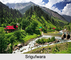
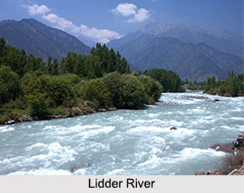
Srigufwara is located on the banks of one and the only tributary of Lidder River. It is 19 kilometres away from the main city Anantnag in Anantnag District of Jammu and Kashmir.
Administration of Srigufwara
On 1st February 2014, Srigufwara was given Tehsil status in Anantnag District after Jammu Kashmir"s Chief Minister Omar Abdullah agreed to the proposal for the creation of new administrative units in the state. Srigufwara is one among 135 newly created Tehsils after state cabinet accept the report submitted by the Cabinet Sub Committee (CSC) headed by Deputy Chief Minister Jammu Kashmir Tara Chand. The number of new administrative units recommended by CSC has been three times more than the Mushtaq Ganai Committee constituted by the Omar Abdullah government as it had recommended creation of only 57 Tehsils. Srigufwara acts as a nerve centre for more than 100 revenue villages, which form its catchments area and get benefit largely. Srigufwara is one among the few fast evolving towns of south Jammu and Kashmir having very important place in the rural economic distribution, development & activity.
Geography of Srigufwara
Srigufwara is located at an elevation of 1684 meters above sea level. Lidder River passes through the town. It flows in a swift narrow stream from Sheshnag lake to the east of Pahalgam. The Lidar passes through many villages. The area is abundant in small canals of different distances. There are minor rivers Mahind Canal and Dadi Canal, which serve the irrigation purpose in the area. Dadi canal initially covered less area but with remodelling, the tail end irrigation has extended to 3,500 acres. Dadi Canal takes its water from the Lidder River at Kathsu near Chatapura. It is 19 Kilometres long and irrigates about 8000 acres of land in Sakhras, Loiseer, Viddy, Darigund, Khiram, Bichhanpura and Sirhama. The Mahind Canal constructed in 1956 AD also takes its water from Lidder near village Sakhras. It is l6 Kilometres long and irrigates about 2500 acres of land.
Forestry in Srigufwara
 The area of Srigufwara has deciduous vegetation and is abundant in coniferous forests including species like fir (Abies spectabilis), silver fir (Abies pindrow), kail (Pinus wallichiana), chir (Pinus roxburghii) and deodar (Cedrus deodara). There are numerous old chinar trees in the area particularly on roadsides. Other trees include willows and popular. Forest provides timber while as grassy meadows in the forest provide fodder for the cattle. The medicinal herbs such as digitalis, menthol, artemisia and belladonna, are also found in these forests.
Climate of Srigufwara
Srigufwara has a temperate climate as Pir Panjal Range of minor Himalayan Mountain Range surrounds it. In winter, however, snowfall is heavier and temperature is relatively low. Due to the presence of mountains, monsoons have a negligible effect in the area. The rainfall is often excessive in spring, moderate in summer, deficient in autumn and moderate in winter. In winters, the temperature may fall up to -5 degree Celsius and in summers, the peak temperature is 37 degree Celsius. Heavy rains and snowfall in winter poses a threat to the residential buildings in the area, which sometimes results in the collapse of the buildings.
Demography of Srigufwara
The population of Srigufwara mostly consists of Muslims belonging to the ethnic group Kashmiri, believed to have migrated from Central Asia and Afghanistan. Gurjar (gujjar) and Bakarwal (Bakerwal) also present in the upper area (nomadic people who come from Rajouri District and other areas of Jammu during summer. In general, they have nomadic character and largely depend on flocks and cattle keeping for their livelihood). Most of the Gujjars are permanent settlers while as "Bakarwals" stay in and around the area prior to their journeys to southern slopes of the Siwaliks and the Margs (Alpine-pastures) of the Central Himalayas Mountain Range.
Agriculture of Srigufwara
The apple and walnut are the prominent fruits grown in the area. The apple season starts from Mid September and people sell the produce across various fruit Markets of India especially the Jammu fruit market in the state itself. Apples are also used for extraction of pulp and juice for preparation of Jams and jellies. There are different varieties of apples grown like Ambri Kashmir (amri), American trail (American apirogue), Maharaji (white dotted red) Hazaratbali (benoni) kesri (cox orange pipin). Other Fruits like pears, cherries, plums, peaches, apricots and almonds are also grown. The fruits are mostly cultivated for economic purpose and little for local consumption. Supply of machinery, equipment and technical advice to the fruit growers by the State Government has greatly helped fruit cultivation. The training of gardeners has helped fruit industry efficiently. The major shrubs are Indigofera heterantha, Viburnum spp., Sorbaria tomentosa etc. Ground cover is very rich and icotyledonus herbs dominate Rumex patientia, Primula spp., and anemone spp.
Visiting information
Srigufwara has well-formed dual lane road connectivity with National Highway 1A (India) which is 10 kilometres away from the main town. During summers the number of tourist vehicles increases considerably giving a boost to the local economy. Major portions of pilgrims to Amarnath Temple also pass through the area.
Related Articles
Cities of Jammu and Kashmir
Anantnag District
Jammu and Kashmir
Culture of Jammu and Kashmir
Jammu and Kashmir, Indian State
Costumes of Jammu and Kashmir


