 Geography of West Tripura district includes the physical subdivisions of this Indian district and also its climatic conditions.
Location of West Tripura District
The geographical coordinates of West Tripura district is between latitude 23 degree 16 minutes north and 24 degree and14 minutes and longitude 91 degree, 9 minutes and 92 degree and 47 minutes east. The region of West Tripura district is surrounded by South Tripura in the southern part, Bangladesh in the northern part and North Tripura towards the western part. West Tripura district occupies a total area measuring about 3, 544 square kilometres. The district headquarters of West Tripura district is based at Agartala, which is the capital of the State.
Physical Features of West Tripura District
The land of Tripura is interwoven with low-lying hilly tracts, which lends an undulating surface to the area and is henceforth termed as `Hill Tipperah`. Arathamura, Deotamura and Baramura hill ranges are amongst the six mountain ranges of Tripura, which lie partly in West Tripura district. The Baramura ranges boast of Saisum Sib, which is its highest peak standing tall at 249 metres. The ranges of Arathamura originate from the sub division of Amarpur, South Tripura district and continue to Khowai sub division, West Tripura district. It extends alongside the border region of North Tripura and West Tripura. Niungnanwra Peak is its highest peak which measures about 481 metres in height.
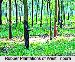
It is said that West Tripura district possessed abundant forest resources and vegetation in the past, which is now being threatened due to increase of the local population as well as indiscriminate deforestation. Such human activities which include `Jhum` cultivation have rendered large tracts of land area infertile and susceptible to soil erosion. Rubber plantation which was introduced here was quite successful since this crop derived the optimum temperature and soil conditions necessary for its survival. Today West Tripura reaps the benefits of a thriving economy which contributes to the overall economic growth of the State. The State Government is promoting the development of rubber cultivation by providing a public service enterprise named Tripura Forest Development and Plantation Corporation Limited. West Tripura district is also known for its coffee plantations. The inhabitants of the remote forest locales of West Tripura district depend on the supply of firewood for domestic utility. Therefore this is also among the significant sources of income for the regional people dwelling here.
Rivers of West Tripura District
Gomati River is one of the principal rivers which flows through the district, which is created by the confluence of two rivulets named Sarma and Raima. While the source of Sarma is Atharamura range and Raima originates from Longtharai range, both these rivulets meet each other near the region of Dhuchaibari along the boundary of South Tripura district. Thereafter, it assumes the name of `Gomati Nadi` after which it enters the sub divisions of Udaipur and Amarpur, South Tripura before finally entering Sonamura sub division which is situated in West Tripura district. Ekchhari, Chelagang, Rambhadhachhara, Ranigan, Maharanichhara and Kurmachhara are the tributaries of Gomati River on the left bank and the tributaries on the right banks of Gomati River are Noachhara, Sarbongchhara, Saugang, Patavgang, Datakchhara and Labachhara. The Gomati River measures about 166 km in length.
Howrah River is another river flowing across West Tripura whose length is about 53 km. It flows towards the western direction and runs into Bangladesh, after crossing the town of Agartala. It originates from Baramura range and its tributaries on the left bank include Bangeswargang, Dhobatilachhara and Charupanadi. Its right bank tributaries are Debda, Dowaigang and Ghoramara.
Burigang River flows towards the western portion of West Tripura and eventually enters the nation of Bangladesh. Its source is the Baramura hills. The land over which this river flows, is extremely fertile and consist of rich alluvial soil which is appropriate for growing various vegetables, jute, paddy, spices and oil seeds.


