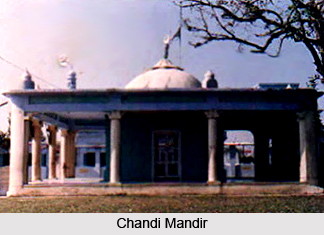
 History of Panchkula District states the origin of its name. The name Panchkula is based on the five irrigation canals (or kuls as they were called, making it Panch Kul or five canals) that take water from Ghaggar River in the uphill section and distribute it from Nada Sahib to Mansa Devi. The Nada canal has now been eroded by the river and most of the kul`s pass through the cantonment of Chandimandir towards Mansa Devi.
As per the history of Panchkula District the district came into existence in the mid of last decade of 20th century. The earliest inhabitants of Panchkula District were primitive people using stone tools of the Palaeolithic age such as choppers, cleavers, hand-axes, etc. These have been discovered from Mansa Devi area (Bilaspur), Pinjore and Suketri. In the ancient time Aryans traversed the region emotionally. Further, the early history of Panchkula District also says that it was associated with Pandavas. The place was known as Panchpura later got distorted to Pinjore. Pinjore is also mentioned in ancient literature. The region was also indirectly under the sway of the foreign Kushan and Yaudhey rulers. This fact is corroborated from the recent findings of Kushan bricks from the adjacent territories of present Ambala District. According to historical accounts, this region had been a part of Gupta dynasty. This fact is based on discovery of silver coins of Gupta dynasty.
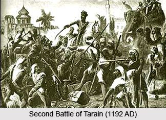
Towards the close of the seventh and first part of the eighth century AD, Panchkula District came under the rulers of Kashmir. Medieval history of Panchkula District also says that during 12th century AD, the area was acquired by the Chauhans of Delhi. They restored peace and order in the area including adjoining district of Ambala. The inscription dated 1164 AD gives an idea of the role which the region played in opposing the Muslim invaders. In this context, it is said that Kilhana, was appointed as governor of Hansi and he defeated the ruler of Panchpura (Pinjore) and extended Chauhan rule over that region. The district finally passed on to the Muslim rule as a result of the decisive victory of Muhammad Ghori over Prithviraj Chauhan in the Second Battle of Tarain (1192 AD). After the death Muhammad Ghori, Qutub-ud-din Aibak established Muslim rule in Northern India. The region was also included in the Delhi Sultanate.
Consequently, the adjacent territories and this area went out of the control of Tughlaqs. The invasion of Timur (1398 AD) destroyed the whole countryside in the region up to Shivalik hills (possibly including Pinjore). But his sway did not last for a long period. Thereafter the area passed on to the Mughals. Akbar had a vast area under his control including this region. As per the history, later on the region was conquered by Rohillas but they were soon expelled by the Marathas. The Marathas were defeated by the British rulers and major portion of this region passed under the British administration in 1803.
Modern history of Panchkula District suggests that the area now forming part of Bilaspur village was under the ruler of Manimajra. The ruler of Manimajra (Gurbaksh Singh) constructed the old shrine of Mata Mansa Devi in 1815 AD. The area now including Kalka was a part of erstwhile princely state of Patiala but was acquired by the British in 1846. Later on it was included in Shimla district. After taking over the chiefs of Ambala area under their protection, the British controlled the affairs of all the states in the region in a most effective manner through political agency at Ambala. By 1846, several chieftainships had lapsed owing to their failure to have male heirs and so called break-down of administrative machinery. The British acquired strips of territory around Ambala which was included into Ambala District.
By 1858, entire Haryana territory became a part of Punjab. The Kalka area, a part of Shimla district, was transferred to Ambala district in 1899. Prior to the formation of Haryana in November, 1966, Ambala district had six tehsils but during the re-organisation it lost Nalagarh tehsil to Himachal Pradesh, Rupnagar tehsil and major portion of Kharar tehsil to Punjab and a few villages to the newly formed Union Territory Chandigarh. Ambala district retained only three tehsils - Ambala, Jagadhri and Naraingarh including 153 villages and Kalka town transferred from Kharar tehsil. Later, in 1967, 153 villages and Kalka town were taken out of Naraingarh tehsil and formed into separate Kalka tehsil. There was no jurisdictional change during the decade 1971 to 1981 with reference to Kalka tehsil. Ambala district experienced jurisdictional changes during the decade1981 to 1991. Panchkula tehsil was created by transferring 77 villages of Kalka tehsil and 19 villages of Naraingarh tehsil in October, 1989. Out of these 96 villages, four villages were fully merged in Panchkula Urban Estate. The full-fledged Panchkula District came into existence with effect from 15th of August, 1995.


