Aurangabad District lies between 24.75 degrees north and 84.37 degrees east. Aurangabad District is bounded by Gaya district in the east, to the west is Rohtas District. To the south of Aurangabad is Palamau and to the north lies Arwal. There are two sub-divisions of this district, Aurangabad and Daudnagar. The whole district is divided into eleven blocks, two municipalities, three sub-scheduled areas, 203 Panchayats, 1884 villages, 2838 wards, 19 police stations and 6 police-out-posts. The headquarters of the district, Aurangabad is Aurangabad. The area of the Aurangabad District is 3305 square kilometers.
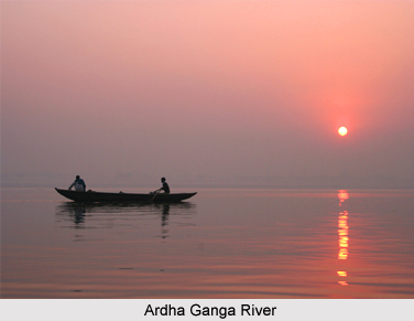
Three big rivers of Aurangabad District are Batane River, Adari River and Madar River. The hills of Vindhya Mountain ranges that are present in the district are Chalho, Dwarpal and Umga. Ardha Ganga is also an important river of Aurangabad District. A few areas of Nabinagar, Kutumba, Deo and Madanpur blocks are surrounded with hills. The Grand Trunk Road passes through the centre of the district of Aurangabad.
 Aurangabad has generally a tropical climate. During the summer days temperature rises up to 40 to 50 degree Celsius, whereas during the winter temperature falls almost near five degrees Celsius. Average rain fall in the region is around 50 to 75 centimeters. The soil of Aurangabad district is highly suitable for the agriculture of paddy, wheat and sugarcane. Betel leaves are grown at a large scale in Aurangabad. In fact the irrigation-planning has made the land of this district most fertile and suitable for agriculture. Three fourth part of this district is irrigated by Son River.
The rivers and hills of Aurangabad District are full of valuable raw materials for the purpose of building work. Precious stones like Gomed, Garnet, Sfatik, Mariyam Hauledil are found in those hills in raw form.
This article is a stub. You can enrich by adding more information to it. Send your Write Up to content@indianetzone.com


