 Mountain passes in Ladakh are the ideal destinations of road trip. Ladakh in Jammu and Kashmir got its name from the high altitude mountain passes. "La" means passes and "Dhak" means many. Ladakh literally means the land of many passes. Being an essentially mountainous place in Pir Panjal Range and Himalayan Mountain Range, they can be seen prevailing throughout the length and breadth of the region.
The land of Ladakh is covered by the Himalayas, the barrier between the Indian subcontinent and the Tibetan plateau. This gives way to a number of complex of ranges and sub-ranges. These, and the river valleys dividing them, form a system of rough parallels in the general direction south-east to north-west. The very outermost of these ranges are the Shiwaliks which form the foothills that connect the whole system with the Indo-Gangetic plain. The Dhauladhar and the Pir Panjal, also south of the main range, enfold the valleys of Kangra and Kashmir. The mountain passes of Ladakh do not consist of any major peaks. The average height of the Ladakh range is a little less than 6000 metres, and few of its passes are less than 5000 metres. The Pang-gong Range runs parallel to the Ladakh range and is some 100 kilometers northwest from Chushul. It is an imposing chain of mountains with its highest peak rising to over 6700 metres, while its northern slopes are heavily glaciated. Apart from these, other important passes running through Ladakh are the Rohtang Pass, Zoji La, Baralacha-La, Khardung La, Namika La, Taglang La, Fotu La, Lachulung La, Taglang La etc.
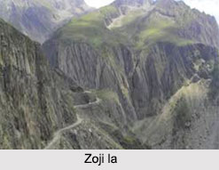
Zoji la
Zoji la mountain pass of Ladakh is considered to be one of the highest mountain passes of the world. This pass creates the boundary between Kashmir and Ladakh. The Srinagar-Ladakh highway passes through the 11,578 feet high Zoji la Pass rests on the lower depression of the Himalayan ranges, about 100 kms from Srinagar.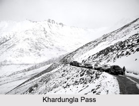 This is the first of the passes on the Srinagar - Leh Highway and it receives the heaviest snowfall during winter, sometimes hampering the normal traffic of the region.
Khardungla Pass
Khardungla Pass lies at a height of 18,380 feet, and it is the gateway to the Siachen Glacier- the highest battle ground in the world. This pass is said to be the world`s highest motorable road and the favourite place for the bikers.
Rohtang Pass
Rohtang Pass is at a height of 13,000 ft or 3,978 metre, located 51 kms from Manali and connects the Kullu Valley with the Lahul and Spiti valley of Himachal Pradesh. This mountain pass is open from May to November and is considered to be very dangerous because of unpredictable snowstorms and blizzards. This is one of the most popular tourist spots in Ladakh and remains populated during the summer season.
Baralacha-La
Baralacha-La lies at the lofty height of 16,050 ft or 4,892m. It is a high mountain pass that connects the Lahaul district in Himachal Pradesh to Ladakh in Jammu & Kashmir. The view from Baralacha-La pass is spectacular with the Himalayas covering the horizon.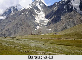
Lachulung La
Lachulung La is lying at 16,600 ft or 5,059 m. It is on the Zanskar Range. This pass is now only for the commercial use.
Taglang La
Taglang La pass is also located on the Zanskar Range of Jammu and Kashmir. The average elevation of Taglang La is 17,469 ft or 5,325 meters. It is a resting place for nomadic Changpa herdsmen, which are dominant in India and China as well.
Ladakh lies between the crest of the Himalayas and the Karakoram amidst a number of ridges and valleys of yet more major mountain systems. From the South to the North, these consist of the Himalaya itself, falling to the trough of the Zanskar and Suru valley; the Zanskar range; the Indus valley, the Ladakh range. It extends into Tibet as the Kailash range, and creates the Pang-gong range; the valley of the Shayok. This is a major tributary of the Indus River; and dwarfing them all rises the Karakoram, which here forms the watershed between India and central Asia.
Related Articles
Cities of Jammu and Kashmir
Ladakh
Mountain Passes in Ladakh
Mana Pass
Jammu & Kashmir
Kashmir, Jammu and Kashmir, India
Adventure Sports in Jammu & Kashmir
Srinagar District
Adventure Tourism in India
Trekking