 The city of Mathabhanga is located in the Cooch Behar district of the eastern state of India, West Bengal. It is located in the northern part of West Bengal. Coochbehar, the district headquarters, is located in its east at a distance of 21 km. The neighbouring towns are Sitalkuchi, Gosanimari Bandar, Ramthenga and Jibdharer Khuti.
Geography of Mathabhanga
Mathabhanga is located at 26.33 ° N and 89.22 ° E. The city has an average elevation of 50 meters. Satranga and Mansai rivers are located near to this city. Mountains of Himalayas are visible during summer, autumn and spring seasons when the sky is clear.
Demography of Mathabhanga
According to Indian Census report of 2001, Mathabhanga had a population of 21,110. Out of it, males comprise 51% of the population and females account for the remaining 49%. In this city, 11% of the population is less than 6 years of age. The Census report also throws light on the literacy rate of the town, which is 76%, higher than the national average literacy rate of 59.5%. To be specific, the male literacy rate is 81% and the female literacy rate is 71%. The literacy rate is high owing to proper school facilities as well as awareness among the people.
Tourism in Mathabhanga
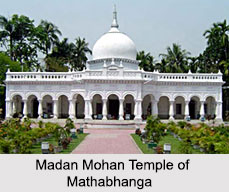
Madan Mohan Temple is the main attraction of Mathabhanga where tourists flock while visiting Mathabhanga. On the occasion of Shivratri, which takes place between February and March, there is a huge fair held in Mathabhanga and the fair has reached wide dimensions over years of celebrations. Some nearby places of this city, where tourists often like to give a visit, are Madhupur Dham, Cooch Behar Royal Palace and Sagar Dighi.
Visiting Information to Mathabhanga
Nearest airport to this city is Cooch Behar Airport. The railway stations that are connected to Mathabhanga are Falakata (24 km), New Cooch Behar (28 km) and New Jalpaiguri (96 km). This city is also well connected to bus routes.
This article is a stub. You can enrich by adding more information to it. Send your Write Up to content@indianetzone.com


