 Pratapgarh District forms a part of Faizabad Division of Uttar Pradesh. Bela Pratapgarh is the district headquarters. Primarily, an agrarian district, Pratapgarh has risen in ranks as the top producer of Aonla fruit. Pratapgarh District is situated at a distance of 39 kms from Sultanpur and 61 kms from Allahabad. Pratapgarh District is at a height of 137 metres above sea level. Pratapgarh District has an area of 3,730 sq km. Total population of the district as per 2001 Census is 144555, out of which male population is 75207 and female population is 69348. Average literacy rate of Pratapgarh according to 2001 Census is around 52 percent (male literacy rate is 62 percent whereas female literacy rate is 40 percent).
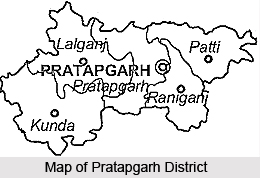
Location of Pratapgarh District
Pratapgarh District lies between 25 degree 34 minutes and 26 degree 11 minutes latitude and between 81 degree 19 minutes and 82 degree 27 minutes longitude. Pratapgarh District is bounded on the north by Sultanpur District, on the south by Allahabad District, on the east by Jaunpur District and on the west by Fatehpur District and north-east by Rae Bareli District. In its south-west Ganga River forms the boundary of the district for about 50 km separating it from Fatehpur and Allahabad and in the extreme north-east Gomti River forms the boundary for about 6 km.
History of Pratapgarh District
Pratapgarh District is named after its headquarters town Bela Pratapgarh commonly known as Pratapgarh. Pratap Singh, a raja of the locality (1628-1682) made his headquarters at Rampur near old town of Aror. There he built a garh (fort) and called it Pratapgarh after his own name. Subsequently the locality around the fort came to be known as Pratapgarh. When the district was constituted in 1858 its headquarters was established at Bela which came to be known as Bela Pratapgarh, the name Bela presumably being derived from the temple of Bela Bhawani on the bank of Sai River. The early history of Pratapgarh District is quite unclear. The region was already inhabited in pre-historic age. Several materials belonging probably to the Neolithic period have been unearthed in Archaeological exploration at Sarai Nahar in Kunda Tehsil of the district.
Economy of Pratapgarh District is dependent on agriculture and the district has highly fertile soils.


