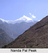
 Nanda Pal Peak is located in the Indian state of Uttarakhand. More specifically, this mountain peak is situated in Pithoragarh district in the eastern part of Uttarakhand. It can also be said to be located on the eastern flank of the Milam Glacier on north south massif, also known as a compact group of mountains. Globally, Nanda Pal can be pinpointed at coordinates 30 degrees 31 minutes 12 seconds north and 80 degrees 08 minutes 24 seconds east. This peak is a Himalayan mountain peak. Its parent range is Kumaon Himalaya. This mountain peak has an elevation of about 6,306 m. The first ascent on Nanda Pal was made in the year 1974. A pass called the Unta Dhura is located in the north direction of the peak.
Other Peaks Situated near Nanda Pal
Other peaks situated near Nanda Pal are the Ikualari (which has a height of about 6059 meters above the mean sea level), the Nanda Gond (which has a height of about 6315 meters above mean sea level) and the Nital Thaur (which has a height of about 6,059 meters above mean sea level).
This article is a stub. You can enrich by adding more information to it. Send your Write Up to content@indianetzone.com
Related Articles
Mountain Peaks of India
Indian Mountains
Indian Mountain Ranges
Gangotri group of mountains, Uttarakhand


