Home > Travel > Cities of India > Geography of Raurkela
Geography of Raurkela
Geography of Raurkela covers the rivers and the industrial belt of iron and steel, as the location is very conducive for having a special economic zone.

Share this Article:

Geography of RaurkelaRaurkela is located at 84.54 degree East longitude and 22.12 degree East latitude in Sundargarh district of Odisha. Raurkela was established from the year 1931 and it was further developed by the Independent Government in India from 1950.

Strategic Location of Rourkela
Rourkela has an elevation of about 219 meters above mean sea level. The area of Rourkela is 200 square kilometres approximately. Being situated on Howrah-Mumbai rail track, Rourkela had an added advantage of the steel plant being set up there.

Soils of Rourkela
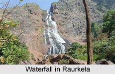
The red and laterite soils are found here which are quite rich in minerals. The area near Rourkela is rich in iron-ore hence a steel plant is situated in Rourkela. Bolani and Barsuan are the two most prominent mines situated near the town. Rourkela is situated in a hilly region.

Hilly Range in Raurkela
Raurkela has the small hilly range. It is small hill range named Durgapur that runs from the heart of the town dividing it into plant area and the steel township. The name "Durgapur" comes from an old village existed at the foothills long time ago before the plant was set up.

Rivers of Rourkela
The Koel and Sankha rivers are the main rivers of Rourkela. There is a single river called Brahmani. The Rourkela Township is divided into two separate townships under Census of India as Steel Township and Civil Township.

Industrial Sectors in Raurkela
The Residential quarters colony of Rourkela Steel Plant having 21 sectors on record (while in reality the Sector - 10, 11 and 12 do not exist, though the area for the same is earmarked) is called Steel Township and the other part is called Civil Township. One smaller township Fertilizer was renamed sector-22, as this township is within the purview of SAIL.

Visiting Information
Rourkela has the good communication filed with buses and trains. The 16 kilometres long Ring Road connects 19 sectors and some other parts of the steel city including old Rourkela. Other layouts include Civil Township, Station Road, Koel Nagar, Jagda, Jhirpani, Panposh, Udit Nagar, Fertiliser Township, Hamirpur, IGH Road and Vedvyas.

Related Articles
Raurkela
Ranji Trophy
Iron and Steel Industry in India
Odisha, Indian state
Cities of Orissa


Share this Article:

Related Articles

More Articles in Cities of India


Ancient North Indian Cities
Ancient North Indian Cities were developed in the early era that is from the time of Mahabharata, and after the decline of Hindu kings in Northern parts. Some have become desolated and some became the archaeological ruins.
Ancient South Indian Cities
Ancient South Indian Cities witness the rise and fall of many empires from the early era.
Ancient Cities of North West India
Ancient Cities of North West India show the Rajput culture from the early phase, but in medieval era it showed the prominence after having a good relation with Mughals.
Ancient West Indian Cities
Ancient West Indian Cities are now completely in ruins, because of the heavy earthquake in some of the regions.
Holy Cities of North West India
Holy Cities of North West India are grown up in the midst of dry and thorny desert lands with Rajputana art and architecture.
Holy Cities of North India
Holy Cities of North India are having the rich history of Hinduism and the entire civilization was grown up with the hands of beliefs, rituals and the evolution of religion.
Holy Cities of South India
Holy Cities of South India gives the detailed cultural formation of Dravidians from the early era, which later developed to the world by the Pallavas and the Cholas.
Holy Cities of Central India
Holy Cities of Central India have the excellence of art and architecture in temples in the early era.
Holy Cities of East India
Holy Cities of East India refer the places of religious importance. Hinduism, Islam, Christianity and Buddhism are widely spread.
Holy Cities of West India
Holy Cities in West India were established by the rulers of Rajputs and the Satvahana Dynasty and the medieval rulers of Junagadh.
Cities of West Uttar Pradesh
Cities of West Uttar Pradesh include Meerut, Bulandshahr, Ghaziabad, Saharanpur, Muzaffarnagar, Bijnor, Bareilly, Rampur, Agra, Aligarh, Mathura and many others. It comprises the western parts of Uttar Pradesh.
Architecture of Ladakh
Architecture of Ladakh is very typically Buddhist due to the strong influence of the religion here. The architecture is in keeping with the geography and climate of the region.
Architecture Of Madurai
Architecture of Madurai reflects the Hindu architectural pattern as is seen in the lakes, temples and palaces.
Port Cities of South India
Port Cities of South India are developed from the early phase of colonial era when the Portuguese and the French traders came to India
Vaishali Ancient City
Vaishali was an ancient prosperous metropolis, which was probably the first republic of the world.
Kudra City
Kudra, the city in Kaimaur District where agriculture is the prime occupation and in this city there is present Asia’s largest seed cold storage.
Thuraiyur in Tamilnadu
Thuraiyur is a municipality town where the inhabitants are mostly dependent on agriculture and handloom industries.
Dharapuram - Tiruppur
Dharapuram is a town located in Tiruppur district in Tamil Nadu. It is said that the Pandavas resided here in the town.
River Ghats in Haridwar
There are several river ghats in Haridwar, which are considered as popular spots among tourists.
Mataundh - Banda District
Mataundh is a prominent `panchayat town` situated in Banda district of Uttar Pradesh.