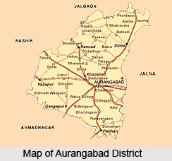
Aurangabad district can commonly be called as a base for a visit to the World Heritage Sites of Ajanta and Ellora. The district of Aurangabad acquired plenty of monuments and a rich culture as its heritage from the middle ages. This is the one and only factor that determines the role of Aurangabad in the history of medieval India as its location. The Aurangabad district was so strategically located that both Mohammed-Bin-Tughlaq and the Mughal monarch Aurangzeb attempted to shift their capital from Delhi to Aurangabad because according to them it would be more efficient for them to control both northern and southern regions of their empires.
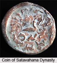
History of Aurangabad district in Maharashtra has witnessed the rise and fall of many dynasties such as the Satavahanas, the Vaustokas, the Chalukya dynasty, the Rashstrakutas, and the Yadavas spanning fifteen centuries till the advent of Muslim rule at the very end of the thirteenth century. The district of Aurangabad has over the centuries become a meeting place of life styles as it is centrally located on the map of India. The district has a long and undeterred history since the Jatava-period to the present day. During the early phase of the ancient period it was governed by a number of tribes. These tribal units were united during the prolonged rule of the Satavahana or Shalivahana (230 B.C. to 230 A.D.).
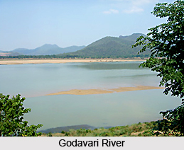
In fact the history of this region begins with the Satavahana dynasty. Their rule witnessed the era of peace and prosperity and hence the district of Aurangabad, then centered around Pratishthan the capital of the Satvahanas for centuries together, became the hub of socio-cultural activities of the Deccan. The Satvahanas gave incentive to trade and commerce and monopolised the Greco-Roman markets as far as textile goods were concerned. These include Paithani, the high-class silken sarees of Paithan. Besides textiles, they established hegemony in the trade of spice, ivory etc. out of which they accrued huge profits which is evident in the material remains of their period. There kingdom lay scattered all over Western India including Maharashtra as they were the lords of the territory between the Narmada River and the Kaveri River.
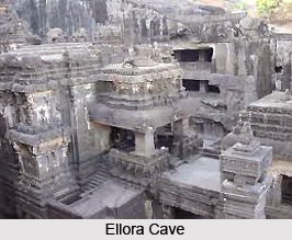
In the intervening years the region began to flourish as it was situated on the caravan routes introduced by the Satvahanas ages ago. The capital Prastishan was linked with the above routes, along with ports and harbours on the one hand and land-emporia like Sarsvati, Pataliputra, Avanti, Takshila etc on the other. During the early centuries of the Christian era, the commercial regions were in the hands of the Buddhist community. Therefore, due to their stronghold here, a large number of Buddhist caves were excavated along these trade routes. Later on Jain and Brahmanical caves were also excavated along with the Buddhist caves. The caves have served a very important purpose down the ages in the maintenance of historical records. Not only did they provide residence to the roaming ascetics during the rainy season, but they also promoted the cause of their faith. They served as educational centres devoted to the cause of cultural synthesis. The caves are mainly of two types-Chaityas i.e. prayer halls and Viharas i.e. residential units. They are known to have been functioning till the end of 13th century A.D.
The district further prospered under the rule of the Yadavas of Devagiri. The set up their capital at Devagiri and also established a huge fort here which is still a popular tourist destination. The fall of this dynasty was unexpected and untimely. The invasion of Ala-ud-din Khilji changed the face of the Deccan. Following this, the district was exposed to a long succession of Muslim rulers. Prominent among them were the Tughlaqs, the Nizams of Ahmednagar, the rulers of the Mughal dynasty and the Nizams of Hyderabad. Muhammad bin Tughluq tried to shift his capital from Delhi to Daulatabad. For this purpose, he tried to improve the infrastructure of Daulatabad. However he changed his decision due to some geographical constraints and the fate of Daulatabad was sealed forever. Malik-Ambar also tried to defend the old hamlet of Aurangabad against the mighty Mughal rule but his enterprise proved unsuccessful. In the last phase of the 18th century Aurangzeb tried to develop Aurangabad along the lines of Delhi, and even perfected the defence apparatus in and around Aurangabad. After his demise Chinkiliza khan, the Nizam became the next ruler of this territory. He made the city of Aurangabad his first capital. However, he migrated from Aurangabad to Hyderabad after a few decades.
Under the reign of the Mughal king Aurangzeb, Aurangabad district became the seat of powerful Mughal Empire for a short span. The predecessors of Aurangzeb preferred all the locations of north including that of Agra, Delhi and Lahore to be the administrative center but Aurangzeb`s move was not unopposed. It was during this time that the Mughal court moved to Aurangabad and remained there till the death of Aurangzeb. During the rule of Aurangzeb many historical gems like Bibi-Ka-Maqbara and a medieval watermill known as Panchakki , built in the 17th century. The textiles of Aurangabad district became much sought after and even in the recent days the weavers of Aurangabad are known all over the nation for producing fine textiles like pathani, himroo and kimkhwab. The Aurangabad district also offers a host of tourist attractions but the crowning glory however remains to be the famous Buddhist cave at Ajanta and Ellora. It was built during the 200 B.C. and 650 A.D. The viharas and the chaityas of the Ajanta are masterpieces and so are the incredibly ornate temples carved out of the hard rock of Ellora. All these tourist spots have dining and boarding facilities for overnight stops or an elongated vacation.