 Uran is part of Navi Mumbai city. Uran is located in the Raigad district near Panvel and Karjat. Uran is situated east of Mumbai across the Dharamtar Creek, and is primarily a fishing village, which has developed into a special economic zone.
Uran is famous for its salt pans. A revolt by salt pan owners against the government decision to build a sea port occurred, but the sea port has now proved to be the main source of income to most of the residents and nearby villages, as major projects and warehouses have opened nearby.
Location of Uran
The latitudinal and longitudinal limit of Uran is about 18.88 degree north to 72.94 degree east. Uran has an average elevation of 21 metres. Uran is surrounded by sea on three sides. On each side there are the villages like the Karanja Village, Pirvadi and Mora Village respectively. Uran is composed of Sheva, Bokadvira, Mulekhand, Chirner, Dighode, Dhakti Jui, Vindhane, Mothi Jui, Koproli, Vasheni, Khopte, Chanje, Karanja, Nagaon, Bori, Bandhilwadi, Aveda,Bajarpur,Vinayak, Ambikawadi, Kathe Ali, Funde, Jaskhar, Dongree, Panje, Dastaan, Jasai, any many more villages.
Demography of Uran
According to the Population census of 2001, Uran had a population of 23,254. 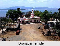 The males constitute 53 percent of the population and females consist of 47 percent. Uran has an average literacy rate of 79 percent, higher than the national average of 59.5 percent. The male literacy rate is 83 percent, and female literacy rate is 75 percent. In Uran, 11 percent of the population is under 6 years of age.
Economy of Uran
The economy of Uran is mostly dependant on fishing. About 80% of the fish production of Mumbai comes from the fishermen based out of Uran residing in the villages of Karanja and Mora. These people are known as Koli. The majority of Koli people have the surname "Nakhawa" or "Koli". The second major occupation is agriculture. It contributes to the production of rice in the Raigad district. Raigad is the second largest district in terms of rice production in India.
Tourism of Uran
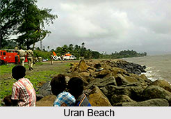
Uran, a well developed village in Maharashtra consists of number of temples. Some of the pilgrimage tourism destinations are Dronagiri temple of Karanja Village, Ratneshwari temple of Jhaskar, Vinayak temple of Vinayak, Mankeshwar temple, Shri Dutta Mandir of Devulwadi, Saibaba temple of Mora, Shree Ragobha Mandir, Ransai Dam, Maha Ganpati temple, Shree Saibaba temple, Ambikawadi, Nagaon. While on the contrary, Dharamtar Creek, Chirner Village, Uran Beach and Pirwadi Sea shore are known as the famous weekend gateway of Maharashtrans.