Introduction
 Darbhanga District is a significant administrative district of Bihar. It is one of the 37 districts of the state with its headquarters at Darbhanga. Darbhanga District occupies a total geographical area of 2279 sq km. It is situated between longitude 85 degree 45 minutes to 86 degree 25 minutes east and latitude 25 degree 53 minutes to 26 degree 27 minutes north. Darbhanga District is bounded on the north by Madhubani District, on the south by Samastipur District, on the east by Saharsa District and on the west by Sitamarhi District and Muzaffarpur District. Main languages spoken in this district are Maithili language, Hindi language and Urdu language. Administration of Darbhanga District comprises three civil sub-divisions, 18 Blocks, 329 Panchayats, 1269 villages and 23 Police Stations. There is also a municipal corporation having 37 wards in the urban area.
History of Darbhanga District
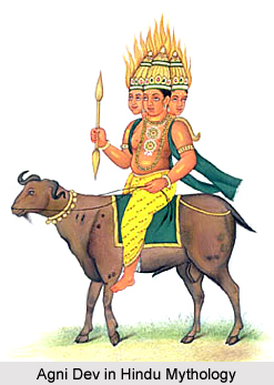 History of Darbhanga District in Bihar dates back to the Ramayana and Mahabharata periods. According to the Vedic sources, the Videhas of Aryan stock first migrated to the area from the banks of Saraswati in Punjab. They were guided to the east of Budhi Gandak River by Lord Agni, God of Fire. Settlements were established and, thus, flourished the kingdom of Videhas. In course of time, the Janaks ruled Videhas. In this line of kings there was a very famous king named Mithi. To commemorate his greatness the territory was named as Mithila. Another famous king was Janak Sirdhwaja. Traditions also speak of Kapila Muni`s relationship with this area that propounded the Sankhya philosophy. Association of this area with Pandavas is also evident by the belief that they stayed here during their period of exile.
Further, according to the history of Darbhanga District, the name of the district has been derived from its headquarters and principal town, which is said to have been founded by Darbhangi Khan. It is also said that the name Darbhanga was derived from Dwar-Banga or Dar-e-Bang meaning `The Gateway to Bengal`. Under the British rule, Darbhanga was initially a division of Sarkar Tirhut till it was constituted into a separate district in the year 1875. The sub-divisions of this district were formed as earlier as Darbhanga Sadar in the year 1845, Madhubani in the year 1846 and Samastipur in the year 1867. Moreover, it also states that Darbhanga was a part of Patna Division till the 1908, when the separate Tirhut Division was formed. Darbhanga was made the divisional headquarters in the year 1972 when all the three sub-divisions got the position of independent districts. Thus, in this way Darbhanga District took its present shape.
Geography of Darbhanga District
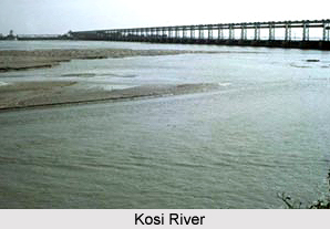
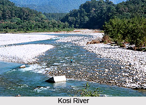 Geography of Darbhanga includes four subdivisions land vast areas of alluvial plains and does not possess hilly regions. The total area of Darbhanga district measures about 2, 279 square kilometers. Darbhanga`s eastern portion comprises Biraul, Ghanshyampur and Kusheshwarsthan and these regions are filled with fresh deposits of silt which had been collected by Kosi River. Floods in the River Kosi greatly affected these areas till the Kosi embankment was constructed as part of the Second Five Year Plan. Wild marshes cover huge areas of sandy land. The most fertile portion of Darbhanga is the area which is present in the southern part of Budhi Gandak River. Rabi crops grow quite well here. The area of Doab which is present near the rivers of Burhi Gandak and Bagmati is another important fertile tract of land in this district. The Sadar subdivision is the fourth part of Darbhanga. Several streams irrigate these areas of land.
Four main rivers, namely, Kamala River, Baghmati River, Tiljuga River, and Little Baghmati River are adequate sources of water for Darbhanga district. Besides these rivers, many other Himalayan rivers water this region. Baghmati River originates from the district of Muzaffarpur and enters Darbhanga and it acts as a boundary between Samastipur and Darbhanga district. Thereafter this river joins the Burhi Gandak River near the area of Rosera. Kamla River flows across Darbhanga at the place called Singar Pandaul. This river joins Tiljuga River at the south-eastern part of the block of Rosera. Little Bagmati River flows through Madhubani district near Pali.
Dry climate is a distinct characteristic of Darbhanga district. Winter season commences in the month of November and lasts till February. Generally, monsoons, winter and summer season are the main seasons of the district. The month of March is characterized by a pleasant climate. During March, westerly winds start blowing in the second half of March. Therefore at this time, the temperature shoots up to a great extent. During the month of May, the temperature rises up to over 42øC and rains arrive in June. Humidity is at its maximum, especially in monsoons. The rainy season continues till August. However, till October, Darbhanga experiences moderate rainfall. The average rainfall which occurs here is approximately about 1142.3 mm. Nearly 92% of aggregate quantity of rainfall takes place in monsoons.
Demography of Darbhanga District
According to the 2011 Census, Darbhanga district had a population of 3,921,971. Out of which the male and female were 2,053,043 and 1,868,928 respectively. The population of Darbhanga District constituted 3.78 percent of total population of Bihar. The average literacy rate of Darbhanga in 2011 was 58.26 percent compared to 44.33 percent of 2001. If things are looked out at gender wise, male and female literacy were 68.58 percent and 46.88 percent respectively. The total literate in Darbhanga District were 1,876,638 of which male and female were 1,158,664 and 717,974 respectively.
Culture of Darbhanga District
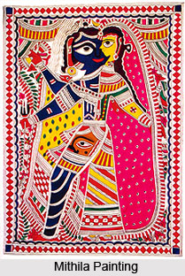 Culture of Darbhanga district is enriched with rich traditions and customs, among which folk arts is worth mentioning. Since Darbhanga occupies the centrestage in the field of culture and traditions, it is often referred to as Bihar`s cultural capital. Mithila painting is a renowned form of folk arts in the state of Bihar, particularly in Darbhanga. Traditional forms of theatre comprise `Madhushrawani`, `Natua Nach`, `Nautanki` and `Sama Chakeva`. Inhabitants of Darbhanga district interact with each other with the aide of Maithili language.
Numerous fairs are organized in this district like `Dussehra Mela`, `Divali Mela`, `Kartik Purnima Mela`, `Janmashtami Mela` and others. `Sauratha Sabha` is a special Mela where brides are present and weddings are arranged. Mithila Chetna Parishad and Adarsh Kala Manch are the two different artistic groups who organize various forms of folk arts in the area of Mithila. Plays conducted by these artistic groups are popular throughout the country. Amateur artists arrange several kinds of plays, especially in the region of Madanpur. However, financial insecurities amongst these groups have restricted their performances to festivals like Chitragupta Puja and Chhat.
Tourism in Darbhanga District
 Tourism in Darbhanga District means visits to several religious places like temples and mosques, museums, nature parks, ponds, gardens and palaces. There are a number of palaces built by the successive Maharajas, important among them being Nargauna Palace, Anandbagh Bhawan and Bela Palace. It is said that the Maharajas of Darbhanga have traditionally been very great patrons of art and literature and through their magnificence have always provided encouragement to the scholars of Maithili and Sanskrit. Culture of Darbhanga District is another aspect that attracts the travellers from all parts of the country.
Details of the various tourist places including religious places as well as historical sites are as follows -
Ahilya Asthan:It is famous historical temple, situated about 3 kms south of Kamtaul Railway Station in Jale Block. This place is known as Ahilya gram. The temple is dedicated to Ahalya, wife of Gautama Rishi. Large fairs are held every year on the occasion of Ramnavami in Chaitra month.
Brahmpur: The village is situated about 8 kms away from Kamtaul and 19 kms southeast of Jogiara. The village is noted for the Gautama Kund and a temple of Gautama Rishi. The village has a Khadi Gamodyaog centre and a Khadi store.
Chhaprar: The village is situated in Bahadurpur block, at a distance of about 10 kms from district headquarter. It has a temple of Lord Mahadeva on the bank of the Kamla River around which fairs are held on Kartik and Maghi Purnima.
Kusheshwar Sthan: It is an important religious place, situated about 16 Kms east of Singhia and 22 Kms northeast of Samastipur. It is noted for the temple of Lord Shiva known as Kusheshwarasthan.
Mahinam-Mahadeo-sthan: It is a temple of Lord Shiva situated at a distance of about 5 Kms. from the Darbhanga-Biraul pucca road. Large annual fairs are held here on the occasion of Kartik and Maghi Purnima.
Nawadah Durga-sthan: It is a famous temple of Goddess Durga located on the Majkora Nawadah Road. The place is visited by hundred of devotees everyday. Dussehra festival is celebrated here with great enthusiasm.
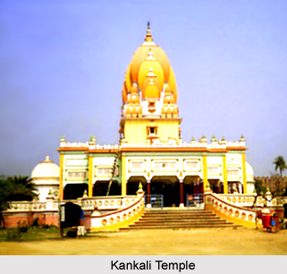
Kankali Temple: Kankali temple is two km north-west of Darbhanga Railway station in the premises of Qila of Darbhanga Maharaj.
Masjid at Darbhanga Tower: It is situated at two km west from the Darbhanga Railway Station.
Maharaja Laxmiswar Singh Museum: Maharaja Laxmiswar Singh Museum was established on 16th of September 1977. It is situated just west south of Darbhanga Railway Station.
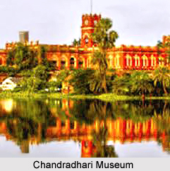
Chandradhari Museum, Darbhanga: This museum was established on 7th December 1957. It includes various galleries like Glass Gallery, Textile Gallery, Miniature Painting Gallery, Stone Sculpture Gallery, Wood Gallery, Mother of Pearls Gallery, Natural History Gallery, Ivory Gallery and Brass Gallery.
These tourism attractions of Darbhanga District are worth seeing. Thus, it can be said that tourism in Darbhanga District means a memorable and enriching experience for the visitors.


