Introduction
 Tirunelveli district is the penultimate southern-most district of Tamil Nadu which is also described as a microcosm of the state. This district possesses diverse geographical and physical features like lofty mountains and low plains, cascades and rivers, seacoast and thick inland forest, fertile alluvium and sandy soils, a variety of flora and fauna, and protected wildlife. The crawling clouds on the Western Ghats, the picturesque Pothigai hills and the Courtallam water falls are the prominent features which make it unique. The district consists of all the five geographical divisions referred to in Tamil literature. The Western Ghats form the Kurinji region; the Kalakkadu and Mundanthurai forests form the Mullai region; the lands watered by the Tamiraparani and other rivers fall under Marudham; the Radhapuram sea coast is its Neithal land and the Teri land forms the Palai region. The district is abundant in centers of natural beauty, pilgrimage, architectural eminence and memorials to great warriors of Indian freedom struggle.
History of Tirunelveli district
 History of Tirunelveli district in Tamil Nadu preserves a number of information with regard to the origin of the name of this district as Tirunelveli. This district is the southern-most district in the state which is described as a microcosm of Tamil Nadu, due to its mosaic and varied physical and geographical features including low plains and lofty mountains, dry Teri structures, cascades and rivers, thick inland forest and seacoast, fertile alluvium and sandy soils, a variety of fauna and flora and protected wild life.
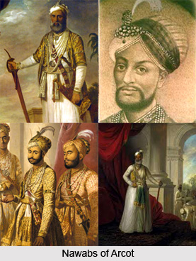
Mudikonda Cholamandalam of the Imperial Cholas, Thenpandiyanadu of the early Pandyas, Tirunelveli Seemai of the Nayaks, Tinnevelly district of the British East India Company and the British administration and Tirunelveli district of Independent India was separated on the 20th of October 1986. The separated districts were known as Chidambaranar district and Nellai-Kattabomman district and later the name of the district was christened as Tirunelveli-Kattabomman district. By the decision of the Government of Tamil Nadu to name all the districts by the name of the headquarter town, Tirunelveli-Kattabomman district was named Tirunelveli district and Chidambaranar district as Thoothukudi district.
On acquisition from the Nawabs of Arcot in 1801, the British named the place as Tinnevelly district though their headquarters was first placed in Palayamkottai the adjacent town, where the British had their military headquarters during their operations against the Palayakars. There are two reasons which may be attributed for naming it after Tirunelveli. One is because, it was and is the chief town of the district and the other is that it was already called as Tirunelveli Seemai under the Nayaks and Nawabs.
The Tirunelveli Sthalapurana lay down a tradition for the origin of the name Tirunelveli. According to the Puranic version, one Vedasarma, a staunch devotee of Lord Shiva, while on his pilgrimage from the North to the South was invited by Lord Shiva in his dream to his abode on the banks of the sacred River Tamiraparani. The delighted devotee came to Sindupoondhurai on the banks of the river and stayed there with his family. Once there was a famine which compelled Vedasarma to collect paddy by way of begging and continuing his daily prayers. One day he spread out the paddy to dry under the Sun before the Lord, and went for his ablutions in Tamiraparani. He prayed to the Lord for rain which he thought could be a remedy for the famine. His prayer was answered and when he was bathing, a thunder storm broke-out and it rained heavily. Vedasarma rushed to the place where he had spread the paddy and to his utter surprise he saw that despite rain around the area, the paddy that he had spread did not get even a single drop of rain and did not get soaked. Since then, according to the Indian Puranas the place is called as `Tiru-nel-veli` or sacred hedged paddy.
Geography of Tirunelveli district
 Geography of Tirunelveli district in Tamil Nadu possesses various types of forests. The total geographical area of the district of Tirunelveli is six thousand eight hundred and twenty three square kilometres. It is located between eight degree eight minutes and nine degree twenty three minutes to the North latitude and seventy seven degree nine minutes and seventy seven degree fifty four minutes to the East longitude. This district is also termed as a microcosm of the state of Tamil Nadu because of its mosaic and diverse physical and geographical features like lofty mountains and low plains, rivers, dry Teri structures and cascades, seacoast and thick inland forest, fertile alluvial and sandy soils, an assortment of flora, fauna, and protected wild life.
The district of Tirunelveli is having its borders as the Gulf of Mannar, the Indian state of Kerala, the Virudhunagar district, Thoothukudi district and the Kanyakumari district. The total wet land of this district is seventy nine thousand six hundred and sixty eight hectares while the dry land is about 3, 58,151 hectares and the forest area covered in this district is about 1,22,055 hectares.
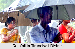
The type of weather in the Tirunelveli district is quite hot in the months of May and June and the maximum temperature during this period sometimes reaches forty five degree Celsius. With the onset of the southwest monsoon by the end of the month of May or during the beginning of June, some drop in the temperature is registered. Main rainy season is from October to the middle of January. The average rain fall in the district is 814.8 mm per annum.
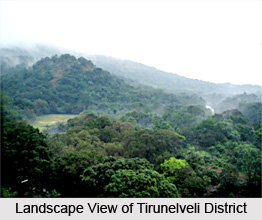
The total area of the forest of Tirunelveli district is 1, 22,055 hectares of which 81700 hectares is set apart for Tiger reserve of Mundanthurai and Kalakadu. The whole forest of the district stretches along the Western Ghats. Several types of forests from luxuriant tropical wet evergreen forests to southern thorn scrub forests occur in this district due to its diverse geographical factors. The forests in the district of Tirunelveli are technically classified as Southern hill top tropical evergreen forests, Southern moist mixed deciduous forests, West Coast tropical evergreen forests, Ochlandra reed forests, Carnatic umbrella thorn forests Southern Euphorsia scrub and Southern thorn scrub. There are several rivers which flow in this district including Tamiraparani, Pachaiyar, Chittar, Korayar, Aluthakanniar, Aintharuviar, Ramanathi, Gadananathi, Mundhal Odai, Jambunathi, Hanumannathi, Gundar, Mottaiyar, Karuppanathi, Manimuthar, Karunaiyar, Nambiyar, Vedamaliyaru, Kothaiyaru, Kottamalaiyaru and Rajasingiyaru rivers.
Administration of Tirunelveli district
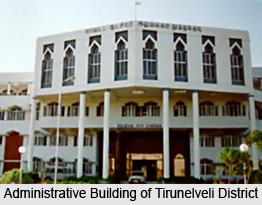 Administration of Tirunelveli district in Tamil Nadu is having the District Collector as the head with his office at the district collectorate. Some of the responsibilities of the District Collector include maintenance of law & order, coordinating a number of welfare and development activities in the district, etc. The Collector is assisted by the District Revenue Officer in matters of land revenue, land matters, public distribution system, etc. and by the Project Officer, District Rural Development Agency for a list of development schemes. There are a number of other officers who help the Collector of the district in his work of general administration.
Some of the officers who assist the Collector in his general administration are Personal Assistant (General), Additional Personal Assistant (Land), Personal Assistant (Development), Personal Assistant (Agriculture), Personal Assistant (Noon Meal Program), Personal Assistant (Small Savings), Personal Assistant (Survey and Land Records), Personal Assistant (Accounts), Special Deputy Collector (PGRC), Assistant Director (Audit), Assistant Director (Panchayats), Assistant Director (Mines), Special Deputy Collector (Stamps), District Adi-Dravidar and Tribal Welfare Officer, Assistant Director (Town Panchayats), District Backward class welfare Officer, District Supply Officer, Assistant Commissioner (Excise), Public Relations Officer and Inspection Cell Officer. There is one municipal corporation, seven municipalities, thirty eight town panchayats, four hundred and twenty five village panchayats, five hundred and fifty nine villages and sixty firkas in the Tirunelveli district of Tamil Nadu state.
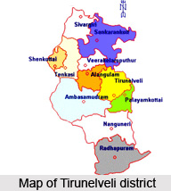
At the divisional level, the Sub Collectors or Revenue Divisional Officers help the Collector in the functioning of the administration. In the district of Tirunelveli there are three Revenue Divisions which are Tirunelveli, Tenkasi and Cheranmahadevi. Tahsildars are the officers` in-charge at the taluk level. In this district, there are eleven taluks which include Tirunelveli, Alangulam, Sankarankovil, Palayamkottai, Ambasamudram, Tenkasi, Nanguneri, Radhapuram, Veerakeralampudur, Shenkottai and Sivagiri.
The Panchayat Union Commissioners at block level in the district of Tirunelveli in the Tamil Nadu state are the officers` in-charge for implementing all the developmental works recommended by the Government at the Block level. There are nineteen Panchayat Unions (Blocks) in this district which are Palayamkottai, Manur, Melaneelithanallur, Sankarankovil, Ambasamudram, Kuruvikulam, Cheranmahadevi, Kalakadu, Nanguneri, Pappakudi, Kadayam, Alangulam, Radhapuram, Vallioor, Keelapavoor, Kadayanallur, Shencottai, Tenkasi and Vasudevanallur. Tahsildars in this district are in charge of the Revenue administration at taluk level. A Tahsildar is assisted by Head Quarters Deputy Tahsildar, Zonal Deputy Tahsildars and Taluk Supply Officer. Each taluk is divided into a number of firkas which comprises a number of Revenue villages. Revenue Inspector at firka level and Village Administrative Officer at Village level assist the Tahsildar.
Education in Tirunelveli district
 Education in Tirunelveli district in Tamil Nadu is highly advanced and for this reason the district is also known as the `Oxford of South India`. The district of Tirunelveli has a large number of educational institutions both in the government and the private sector. There are two universities, about twenty five arts and science colleges, one medical college, Government Siddha medical college, twenty engineering colleges, one law college, about two hundred and forty one pre-primary schools, about one thousand five hundred and one primary schools, four hundred and thirty one middle schools, one hundred and fourteen high schools, one hundred and eighty five higher secondary schools and about twenty eight teachers` training institutes.
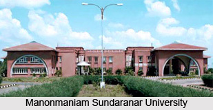
Manonmaniam Sundaranar University which is in short called `MSU` was set up in the year 1990. The university was named after the famous poet, Prof. Sundaram Pillai. It has a strong network of about one hundred and two affiliated colleges. A number of these colleges have contributed considerably to the cause of higher education for many decades. There are five colleges in this district which are more than one hundred years old.
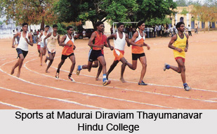 In the year 1878, the number of colleges in the district was two and they were the Madurai Diraviam Thayumanavar Hindu College and St. John`s College. Both of these are the oldest colleges in Tirunelveli district. The first college for women and third college of the district, Sarah Tucker College came up in the year 1895. The fourth college in the district was the St. Xavier`s college of Education and St. Ignatious college of Education (both are training colleges) were established in the year 1950 and 1957 respectively. In the year 1963-64, two more colleges, the Paramakalyani College and the Parasakthi College were formed. Except for Government Arts College for Women, all other colleges are aided private colleges run by different educational trusts. In the district of Tirunelveli, there are three self-financing colleges; they were Saratha College for Women, Sattanathakarayalar College and Jayaraj Annabakkiam College.
In the year 1986, the revenue district of Tirunelveli was bifurcated as Tirunelveli and Thoothukkudi districts and a new post of District Educational Officer at Tenkasi was formed and the name of posts of the District Educational Officer, Tirunelveli Central was changed as District Education Officer, Tirunelveli and the District Educational Officer, Tirunelveli South was redesigned as District Educational Officer, Cheranmahadevi. The three District Education Officers work under the overall control of the Chief Education Officer.
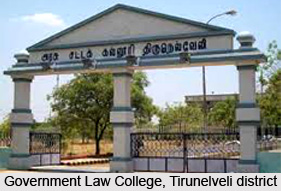
In Tirunelveli district, there is a Government Law College which was opened on the fourteenth of October 1996, with an intake of eighty students for three year Law course. For medical education there is the Tirunelveli Government Medical College and its teaching hospital located in an extensive area of about three hundred and fifty acres of land at High Grounds, Palayamcottai.
 This college was started in the year 1965. The Government Siddha Medical College was started at Palayamkottai on the 30th of November 1964 and it was an affiliated College of the University of Madras till the month of March 1966 and from then on till the year 1988 it was an affiliate of Madurai Kamaraj University and since the month of March 1989 to Dr. MGR Medical University.
History of technical education in the district of Tirunelveli can be traced back to the year 1844 when Mrs. Caldweel, wife of Bishop Caldwell, started a school which is meant for teaching girls in lace making at Idyangudi. The Government of Tamil Nadu set up a State Board of Technical Education and Training and a separate Directorate of Technical Education with effect from the 1st of October 1957. The Directorate of Technical Education has taken over the administration of both engineering colleges and polytechnics in this district since then.
Tourism in Tirunelveli district
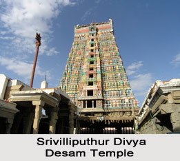
There are several temples of Tirunelveli district which form the major pilgrimage centers in the district. Temples of Tirunelveli district bear the evidences of ancient kings and dynasties that ruled the region. Apart from the temples there are also churches and dargahs which are the major centers of pilgrimage in the district. The Venkatachalapathy temple at Krishnapuram village which is dedicated to Lord Venkatachalapathy with his consorts Sri Devi and Bhu Devi on either side. Other temples in this district include the Nellaiappar temple and the Kanthimathi Ambal temple. The temple of Nellaiappar and Kanthimathi is located at a distance of two kilometres from the Railway station. From a distance itself one can get to enjoy the beautiful view of the great gopuram tower.
Apart from the temples there is the Kappal Matha Church in the Tirunelveli district. Another pilgrimage center is the Holy Trinity Cathedral in this district. It is a small, elegant and beautiful Church constructed in the year 1826 by Rev Rhenius and opened to the public for worship on the 26th of June 1826. There is also another place of pilgrimage where people of all faith including Islam, Christianity, Hinduism, etc. visit regularly. It is known as the Pottalpudur Dargha, the oldest dargha constructed around the year 1674.
The Mundanthurai-Kalakad wildlife sanctuary in Tirunelveli district is developed as a National Tiger Reserve from the year 1988 with a total area of 817 square kilometers in the southernmost Western Ghat ranges.
 The reserve is the southernmost habitat of the tiger. Other predators like panthers, jungle cats, civets, dhole, jackals, and striped hyena are also found here. Another attraction in this district is a tiny village called Koonthankulam. It is in the far south in the taluk of Nanguneri in Tirunelveli District. Migratory birds start visiting this place by later half of December and fly away to their northern homes by June or July after they lay eggs and hatch them and the young ones grow old enough to fly with the elders. One of the excellent health resorts of this district is. The picturesque surroundings with the backdrops of cloud capped spurs of the Western Ghats lend an unusual charm to the falls. Another prominent place of tourist interest is the Pulithevan Palace. Another favourable summer resorts in the district of Tirunelveli is Manjolai. It is situated at an elevation of one thousand one hundred and sixty two square meters. On the way to Manjolai from Manimuthar there is a very beautiful place called Dasan Pool with plenty of fresh water, greens and fine climate. Apart from these there are various other attractions including the two tiers over bridge called Thiruvalluvar Bridge at Tirunelveli Junction, the District Science Centre, etc.
Temples In and Around Tirunelveli
 The Shiva temple is situated in the heart of this major commercial centre. It is dedicated to Nellaiappar and His consort Kanthimathi. The temple was built by a Pandya king in the 7th century and is known for beautifully sculptured mandapams and theerthams. There are two entrances - one is Swami Sannadhi and the other Amman Sannadhi. Tirunelveli is one of the five places where the Lord performed His cosmic dance. It is known as Tambra Sabha.
The Shiva-Parvati marriage is celebrated in the thousand-pillared mandapam in Aippasi during the months of October and November. Vasanta Utsavam is held in April-May. The pillars in the Mani Mandapam render unique musical sounds when struck.
Temples Around Tirunelveli are as follows
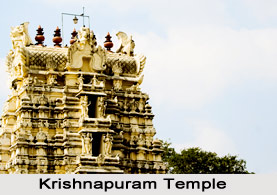
Krishnapuram: The Venkatachalapathy temple is known for rare sculptural workmanship. There are two beautifully carved elephants adorning the entrance to a mandapam, known as Veerappa Naick Mandapam. The pillars here bear images of exquisite beauty depicting scenes from Puranas. It is situated at a distance of 12 km from Tirunelveli.
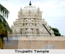
Tiruchendur: The Sri Subramanya temple, one of the six abodes (Arupadai Veedu) of Lord Muruga, stands majestically on the seashore. An impressive gopuram welcomes the visitor. From the town of Tirunelveli the tourists need to travel 60 kilometers to arrive here.
The origin of this rock-cut temple goes back to Puranic days. Mayan, the celestial architect had constructed a Shiva shrine for Muruga`s worship. Muruga had come here with Devas to annihilate Surapadman, the Asura, who had encamped in the mid-ocean fortress off Veeramahendrapuram near Tiruchendur.
After the victory over Surapadman, the Devas and Devaguru Brihaspati worshipped the Lord at Tiruchendur. Hence the temple is also revered as a Navagraha Sthala dedicated to Guru.
 To commemorate the Lord`s victory, Skanda Shashti is celebrated at Tiruchendur as well as in other shrines of Lord Muruga for six days. On the concluding day, Surasamhara is re-enacted. This performance is witnessed by thousands of devotees.
In the sanctum, Lord Subramanya faces east, worshipping Lord Shiva. In one hand He holds a rosary of beads and in the other, flowers to be offered to Shiva. Next to this shrine is another sanctum for Sri Arumuga with His consorts.
On the outer prakaram, there are shrines for Valli and Deivayanai. There are also shrines for Vishnu (in Anantasayanam posture) and Gajalakshmi in a rock-cut niche.
About 60 meters north of the temple alongside the seashore, there is Valli Cave, cut inside natural sandstone rock facing east. There are two images-- one is dedicated to Valli and the other to Dattatreya.
It is customary for pilgrims to have a holy dip at the sea followed by a bath in a freshwater spring on the shores, known as Naazhi Kinaru, before worshipping at the temple.
Adi Sankara had worshipped in this shrine and sung in praise of the Lord in his Subramanya Bhujangam.
Alwar Thirunagari: The Vishnu temple, located 32 km away, is dedicated to Adhinathaswamy. There are 9 sacred Vaishnavite centres on the banks of river Thambraparni. These are known as Nava Tirupatis. Alwar Thirunagari, also called Thirukurugur, is one among them. The other places are Srivaikuntam, Thiruvaragunamangai, Thirukulanthai, Thirupulingudi, Thirukolur, Thiruperai and the two shrines of Thirutholaivillimangalam. The latter two are together called Twin Tirupatis. In Alwar Thirunagari, the worship of Bhudha is considered holy. It is the birthplace of Saint Nammalwar, said to be an incarnation of Vishnu. He was meditating under a holy tamarind tree in the temple for 16 years. Nammalwar was the author of more than a thousand verses of Divya Prabhandam.
Srivaikuntam: A unique feature at the Srivaikuntanatha temple is that the Lord is in standing posture with Adi Sesha providing the shelter. Milk abhisheka is considered very sacred. Srivaikuntam is also one of the Nava Tirupatis. It is considered as a place of importance for Shukra.
Nanguneri: The Vishnu temple here is commonly known as Totadri Mutt. The deity is known as Vaanamaamalai Perumal, who is seated on Adi Sesha with His consorts Sridevi and Bhoodevi. The Seer commands wide respect among a sect of Vaishnavites. Nanguneri is one of the eight Swayamvyakta Kshetras, where God is believed to have appeared of His own accord. It is located 28 km away from Tirvnelveli. At Tirukurungudi, 10 km away, there is another Vishnu temple dedicated to Azhagianambi.
Papanasam: It is situated at the foot of the Pothigai mountain range, from where the Tambraparni river flows down. The temple, dedicated to Papavinasar, is known for absolution of sins.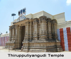
According to a legend, when Lord Shiva married Parvati at Mount Kailash, the weight in the North increased because of the large congregation, tilting the South up. In order to make it even, He asked sage Agastya to go to the South, promising to give him darshan at his place. Agastya chose the Pothigai range and did penance there. As promised, in due course of time, the Divine Couple blessed Agastya in their Kalyana Thirukolam (in wedding glory) at Papanasam and remained there ever after. A Lingam sprouted beneath a Kala tree which is revered as Mukkala Nathar. The deities of Somaskandar, Rishabaroodar with Agastya and Lopamudra by his side are quite noteworthy.
Papanasa Theertham is located near the shrine. A few kilometer up the mountain range are the waterfalls, known as Agastya Theertham and Kalyani Theertham or Paana Theertham. Situated near these falls is a shrine dedicated to Agastya Muni.
The processional deity of Agastya is brought to Papanasam every year from his shrine to witness the celestial wedding of Shiva-Parvati.
Tenkasi: King Parakrama Pandyan once went to Kashi (present day Varanasi) along with his Queen and worshipped Lord Viswanatha. On his way back he had a darshan of Lord Sundareswarar at Madurai. The Lord appeared in his dream that night and bade him build another Kashi temple in the south. The king built the shrine and installed the presiding deity, Kashi Viswanatha, and His consort Lokambika in two shrines. The holy Ganga is believed to have appeared at the Kashi Kinaru at the bidding of the Lord.
At the entrance to the main shrine there are excellent pieces of sculptures.
Courtallam: This popular health resort is situated on the Western Ghats near the Kerala border. There are several waterfalls here and a bath in these cascading falls is said to be very good for both mind and body.
The main fall is adjoining the temple of Sri Kutralanathar (Shiva) and Kuzhalvai Mozhi Amman.
To the north of the temple is the well known Chitra Sabha, one of the 5 such Sabhas where the Lord performed His cosmic dance. The Lord is seen in His Nritya Thandavam posture.
The old waterfalls are 7 km away from the town. The other falls here are Chittaruvi, Shenbagadevi Falls, Thenaruvi, Five Falls and Tiger Falls.
June to September is the best time to visit Courtallam when the waterfalls will be at their best during the south-west monsoon.
 Sankarancoil: According to a legend, Devi Parvati once wished to see Siva and Vishnu in one form. Siva bade her to go to Earth and perform penance. On the Full Moon day in Adi (July-August), Lord Shiva granted her darshan as Sankaranarayana - half Siva and half Vishnu. The famous Adi Tapas festival celebrated here is in commemoration of this penance.
There are 3 separate shrines in the temple. The first enshrines Gomathi Amman, the second Sankaranarayana and the third a Swayambu Lingam found in an ant-hill.
The sand obtained from the ant-hill has healing powers. Pilgrims offer silver and copper cobras in the belief that cobras and scorpions will go away from their residential areas.
The Sri Chakra Peetam in front of the Devi shrine is specially worshipped. People suffering from mental afflictions perform penance here. The sacred Theertham is known as Naga Sunai.
The 10-day Vaikasi Visakam and Navaratri festivals are celebrated in a grand manner. Vijayadasami is a day of victory for the Virgin Goddess over Banasura.
Climate of Tirunelveli District
 Climate of Tirunelveli district in Tamil Nadu during the day time in the coastal regions is cooler than the interior parts by about a degree during summer and southwest monsoon seasons and warmer by one to two degrees during the rest of the year. Starting from the mid February, temperature increases steadily. In the month of May, which is generally the hottest month in the interior parts of the district, the mean daily maximum temperature is 37.1 degree Celsius. The weather is reasonably hot in the months of May and June and the maximum temperature during this period reaches forty five degree Celsius. With the coming of the south-west monsoon in the end of the month of May or in the beginning of June, Mercury drops to some extent. By about mid-October, there is a substantial decrease in both the night and day temperatures.
 The period from the months of November to January, the district experiences the coolest part of the year with the mean daily maximum temperature of about thirty to thirty one degree Celsius in the interior parts. The mean daily minimum temperature in these months in general is about twenty two degree Celsius to twenty three degree Celsius. The relative humidity in general, in this period of the year, is between fifty five and sixty five percent in the interior parts of the district, except during the north-east monsoon season, when it is over sixty five percent. The coastal parts of the district of Tirunelveli in Tamil Nadu state are comparatively more humid. In the months of April and May, the skies get heavily clouded and thunderstorms on many days follow in the afternoons. In the south-west and north-east monsoon seasons, the sky is overcast or heavily clouded. Winds in this district blow generally light to moderate in strength and between the months of May and September winds are generally north-westerly or westerly and from the month of October to February winds are usually north-easterly or northerly.
The major rainy season in the Tirunelveli district is from the month of October to mid-January. During these south-west monsoon season the rainfall is more in the western parts of the district of Tamil Nadu state and the month of November is generally the rainiest month in this district. The average annual rainfall in the district of Tirunelveli is 814.8 millimeters.