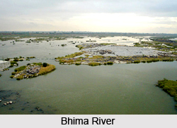
 Geographically Solapur is located between 17.10 to 18.32 degrees north latitude and 74.42 to 76.15 degrees east longitude. The district is situated on the south eastern fringes of the state of Maharashtra and the district is bounded on the north by the Ahmednagar district and Osmanabad district, on the east by Osmanabad and Gulbarga district of the state of Karnataka, on the south by Sangli and Bijapur district and on the west by Pune and Satara district. The major rivers in the district are the Bhima River and the Sina River. The Nira River, Mann River and Bhogawati are its tributaries. The district lies entirely in the Bhima and Sina basins. The whole of the district is drained either by the Bhima River or its tributaries. The Bhima and Sina run south-east. The Nira and Mann run nearly east.
The district in general has a flat or undulating terrain. There is no important hill system in the district. Only to the north of Barshi Taluka, several spurs of the Balaghat range pass south for a few kilometres. There are also a few scattered hills in Karmala, Madha and Malshiras Talukas The low table land and small separate hills in Karmala and Madha Talukas act as a watershed between the Bhima and Sina rivers. The soils of the district can be classified into three main types. These are black soil, coarse grey soil and reddish soil.
According to topography the district is divided in three natural zones:
 Eastern Zone: This comprises of Barshi, North Solapur, South Solapur and Akkalkot Talukas. The soil is medium to deep black and of rich quality. jowar, bajra and pulses are the main crops of this zone.
Central or Tansitional Zone: Mohol, Mangalwedha, eastern part of Pandharpur and Madha Taluka are covered by this zone. Moderate soil and uncertain rainfall marks this zone. Both Kharif and Rabi crops are grown in this part.
Eastern Zone: This comprises of Barshi, North Solapur, South Solapur and Akkalkot Talukas. The soil is medium to deep black and of rich quality. jowar, bajra and pulses are the main crops of this zone.
Central or Tansitional Zone: Mohol, Mangalwedha, eastern part of Pandharpur and Madha Taluka are covered by this zone. Moderate soil and uncertain rainfall marks this zone. Both Kharif and Rabi crops are grown in this part.
Western Zone: Karmala, Sangola and Malshiras Talukas and the western parts of Pandharpur come under this zone. Shallow and poor type of soil, not retentive of moisture marks this part, along with scanty and uncertain rainfall. Rabi crops are mainly grown in Karmala, Pandharpur and Madha Talukas while Kharif crops like bajra and groundnut are grown in Sangola and parts of Malshiras talukas.
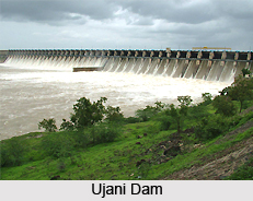
Agro-climatically, the entire district comes under the rain shadow area. Rainfall is uncertain and scanty. The monsoon period is from the second fortnight of June to the end of September bringing rains from south-west monsoon. The average rainfall for the district is 545.4 mms. Due to scanty and non-uniform rains, scarcity conditions prevail in the district. This has adversely affected the socio-economic condition of people. In order to face this situation, the Ujani dam has been built to provide water to the drought-prone areas. During the dry season all the rivers are nearly dry. The length of Bhima River in Solapur district is 289 kms. An area of 296107 hectares is under irrigation in the district from various sources.
The district covers a total geographical area of 14844.6 sq.kms which is 4.82 percent of the total area of the state of Maharashtra. Out of the total area of the district 338.8 sq.kms (2.28 percent) is urban area whereas the remaining 14505.8 sq.kms. (97.72 percent) is rural area. Area wise, Karmala taluka is the biggest covering an area of 1609.7 sq.kms and North Solapur is the smallest covering an area of 736.3 sq.kms.


