Introduction
Beed district is undoubtedly one of the prominent districts of the state of Maharashtra. Apart from having a rich history, the district is also rich in its culture, tradition and economy. The people of the district like to enjoy all the major festivals together, irrespective of religion or caste divisions. The systematically arranged administrative divisions of the district seek to cater to the needs of the entire population, and the Zilla parishad takes care of development administration at the rural level. The numerous tourist destinations located in the district are playing a major role in the promotion of tourism not just in the district but in the state of Maharashtra as well. The district occupies an area of 10,615 sq. km. and its headquarters is at Beed town.

Location of Beed District
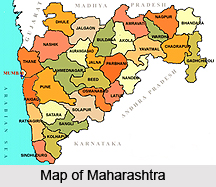
Beed District is situated at the central-Western portion of Aurangabad. It lies between the latitudes of 18.28 and 19.28 and the longitudes of 74.54 and 76.57. The district is bounded by Aurangabad and Jalna in the North, Parbhani and Latur in the East, Ahmednagar and Osmanabad in the South and Ahmednagar in the West.
History of Beed District
History of Beed district is quite rich, and the district has been under the rule of a number of different rulers. The city of Beed located here was called "Champavati Nagari" in the ancient period and there are still some old monuments showing the signs of past glory in the form of city entry doors (called Ves in local language) and city protection walls. The district was a part of the Nizam state before the independence of India and was included within the area of the Hyderabad State, till 1956. When the Indian states were reorganised in 1956, the Marathwada region was included in the state of Mumbai and the Mumbai state was further divided into Maharashtra and Gujarat in 1960. Since then, Beed district has been an integral part of the state of Maharashtra.

Geography of Beed District
Geography of Beed district is determined by the Deccan black basalt stone ranges of Balaghat. This constitutes the main range from Ahmednagar in the west to the border of Beed district in the east. This range divides the district into two parts. The plain area in the North is called Gangathadi (bank of Ganga-Godavari) and the higher part at Balaghat is called Ghat. Many hills exceed the 2500 feet mark from the sea-level. Balaghat range is between the heights of 2000 and 2200 feet, whereas the plains called Gangathadi have heights ranging between 1200 and 1500 feet from sea-level. The height of Ashti Tehsil is between 1750 and 2000 feet from sea-level. The slope of Ashti Tehsil is in the Southern direction.

There are three changes in climate. It is hot from June to September but it may also at times be cold due to the rains. Temperature during this season reaches 40 to 45 degree Celsius. The monsoon generally starts in the 2nd week of June and continues up to the end of the September. The range of monsoon is between 458 mm and 814 mm. From October to February the climate is cold and dry. Cold waves occur at times between November and January. In general, the climate is pleasant. Most of the land of the district is full of rocks and thin layers of soil except Georai and Majalgaon where the land consists of rich fertile black cotton soil. On the banks of the Sindaphana River and in some parts of Ashti, Beed, Kaij and Ambajogai there are a few strips of black rich land but in Patoda, the total land is rocky and thin-layered.
Most of the land in the district is like this. Except in the river belts of Godavari and Sindaphana, there is scarcely any rich fertile soil in the district. River Godavari is the most important river in the district. Other rivers in the district are Sindaphana, Manjara, Bandsura and Van. The other minor streams are Talwar, Kambli, Ruti and Mehkari. Most of these rivers are dry in summer. They flow in summer only if rain is adequate or more than enough.
The main business in the district is agriculture but adequate and timely rains rarely occur, consequently there is at times a scarcity period as most of the agriculture depends on the rain. Two harvests Kharif and Rabi are adopted. In Kharif, the crops are high-bred, and include jowar, bajra, tur, udad, cotton and groundnut while in Rabi the crops are jowar, wheat, harbara, kardai etc. In the annual pattern, main crops are sunflower and summer groundnuts. Fruits and vegetables are grown as per water resources. The commercial crops are sugarcane and cotton and as the number of sugar factories increases, there is more sugarcane.
Administration of Beed District
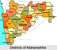
The Beed District is divided into 11 talukas namely Beed, Georai, Ashti, Patoda, Shirur, Wadwani, Ambajogai, Majalgaon, Kaij, Dharur and Parli. For administrative purpose two parts have been formed. One section is at Beed and it includes 1)Beed, 2)Georai, 3)Patoda, 4)Ashti, 5)Shirur(Kasar) Tehsils while other section is Ambajogai that includes 1)Ambajogai, 2)Kaij, 3)Majalgaon, 4)Dharur, 5)Parli(V), 6)Wadwani Tehsils. There are special Deputy Collector offices in these two sections. There are 11 Tehsils and excluding the urban area, there are 11 Panchayat Samities. At Beed, the Zilla Parishad governs all these 11 Panchayat Samities. The district is comprised of 1282 villages, 1115 Gram Panchayats and 6 Municipal Councils. The Beed Nagarpalika is the largest municipal council in the district. There is a huge network of rural hospitals, primary health centres, sub-centres and cottage hospitals for providing health services in the Beed district.
Culture of Beed District
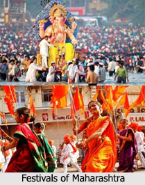
The culture in Beed district is predominantly Maharashtrian. Family, customs and religion hold great importance in the society. The people religiously follow various local customs in marriages and other functions. Most of the people in the district are vegetarian, however, though non-vegetarian foods are also popular among various groups in all sects of society. Achar (pickle), Papad (poppadom), etc are a common part of the diet in the district. The young men of the district mostly wear western outfits and the young women wear Salwar Kameez Dupata. A majority of the married women wear Saris and the elderly males like to wear traditional outfits. The major festivals in the Beed district include Diwali, Holi, Dussehra, Id-ul-Fitr, Eid-ul-Azha, Buddha Jayanti, etc.

Economy of Beed District
The economic status of Beed district is quite impressive. Though the district is considered industrially backward, the people of the district are engaged in a variety of business. There are many dairies located in the district and the milk and dairy business is growing at a fast rate. The fishery business is also doing quite well in the district. Many people in Beed district are involved in electricity production and supply industry as well. Apart from these, there are several sugar factories, spinning mills and a Thermal Power Station in the district.
There are also about 36 ginning factories in the district, as cotton is one of the major crops cultivated in Beed district. Brick manufacturing activity is also an important occupation of this district. Though gradual industrial progress is being made, agriculture remains the main occupation of the people of the district. There are two major agricultural seasons in the district, Kharif and Rabi. Jowar, Bajara, Cotton and Pulses are the main crops cultivated during the Kharif season and in Rabi season, the major crops cultivated include jowar, wheat, gram, safflower, oil seeds, etc. The other crops like sugarcane, groundnut and sunflower, etc. are also cultivated in the district.
Tourism in Beed District
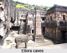
Tourist attractions abound in the district of Beed, and the district makes a major contribution to the tourism sector in Maharashtra. There are many places of tourist attractions located within the district and several people visit the places on a regular basis. Some notable tourist destinations in the Beed district are the Peacock sanctuary at Naigaon, Bendsura Dam at Beed, Shivaji Chouk, Sautada Waterfall, Khajana Bawadi, Dharur Fort, Rameswhar Temple, Kapil Dhar Water Fall, Kapil Dhar Temple, Khadeshwari Mata, Shaheshawali Dargah, Shri Vaidyanath Madir Parali, Kankaleshwar, Jatashankar Temple, Khandeshwari Temple, Khardoba Temple, the Samadhi of pioneer Saint Poet Mukandraj in Ambajogai, etc.

Pilgrimage tourism in Beed district
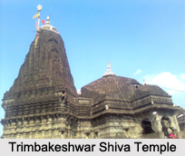
Pilgrimage tourism in Beed district involves visiting the various temples situated here. Most of these temples are ancient constructions and apart from their religious significance, they also have immense historical worth. A prime example of such a temple is the temple of God Vaijinath in Parli. Apart from being one of the twelve jyotirlingas, it also quite an ancient temple, built by Queen Ahilyabai Holkar. Discussed below are the various places of pilgrimage tourism in the district of Beed.
Parli Vaijinath Temple
The temple of God Vaijinath in Parli is one of the twelve jyotirlingas. It is a very sacred as well as a historical place. Queen ahilyabai holkar reconstructed the temple in stone. At the entrance of the temple the grand entrance construction attracts the attention of visitors. Around the temple there are three Kundas. Vaijinath is the fifth jyotirlinga among the twelve. Other famous temples at Parli include the Rajasthani Balaji temple built with a gopuram and the Shani temple.
Yogeshwari temple at Ambejogai
There are three temples here which are believed to be very powerful in fulfilling the desires of the devotees. Godess Yogeshwari is one of them. This historical temple was built in ancient times. Ambejogai is also renowned for being the birthplace of Mukand Raj who wrote 'Vivek Sandhu'.

Rakshbhuvan (Shani Dev)
On the banks Godavari River there is an ancient temple of Shani Maharaj. It is one of the holy places of Shani which is one of the three and a half holy places of god Shani. On the occasion Shani amavasya, thousands of people come from Maharashtra and other states of India to take the blessings of Shani Maharaj . Apart from this there is a holy temple of Panchaleshwar here. The place is a cultural centre for the believers of the Mahananubhava sect.
Chakarwadi
In Chakarwadi there is a samadhi, the burial place of the great Saint Dnyaneshwar Mauli. Mauli was born in Uttreshwar Pimpri and worked for the people there. He is said to have had the blessings of Lord Shiva and Lord Hanuman. On the occasion of Amavasya many people visit the place for Mauli's blessing.
Ashvalinga Temple
Ashvalinga temple is situated in Pimplewadi. There is also the Kartikaya Swami temple located here. The unique feature is that only on Kartika Poornima and Kartika Nakshatra women are allowed to have his Darshana.

Nagnath Temple (Manur)
There is an ancient temple of Lord Shankara. It is said that it is the native place of Babruvahana, the son of Arjuna. It is a place where deathless Ashwathama is said to have been wandering for ever.
Gorakshanath Temple
It is a famous holy site situated on a high hill. Found here is a temple of Lord Mahadeo and the Samadhi of Gorakshanath. It is said that Gorakshnath threw a golden brick on that hill and the temple was built at the site.
Shri Kshetra Narayan
This place is considered to be quite sacred as it is said that a linga appears here automatically after every 12 years. The holy place, called `Dhakti Pandhari` is situated on a hill.
Pohicha Dev
Situated on high hills, this is a famous place among the followers of the Mahananubhav sect, who worship at the omni-potent Lord Datta`s temple. The carvings of the temple have been remarkably made and are very attractive to behold. It is said that Shri Chakaradhar Swami, the founder of the Mahanubhav sect, visited that place.
Navagan Rajuri
It is a ten minute drive from Beed on the Beed-Nagar road in the west. This is a holy place famous for the Lord Navagan Ganpati temple. The greatest attraction of the place is a splendid idol of Lord Siddh Ganesh having four heads facing the four directions.
Namalgaon
It is an ancient village famous for the temple of Lord Ganesha found here. The standing idol of Lord Ganesha in the temple is very attractive. Here, there is a union of the rivers Karpara, Bendsura and the Narmada River. Besides this there is also a water tank. It is believed that people who suffer from leprosy get relief when they take a bath in the tank.
Sidhawad
To the East of Namalgaon there is a temple of Shri Kolhapurwasini Laxmidevi. There is a wad (banyan tree), situated to the west of the temple. Because of this, the name of the temple was given as village became Siddhawad.
Apart from the above mentioned, there are many other temples located in the district of Beed. These include the Dev Dahiphal, Bankat Swami Temple, Neknoor Dargah, Beteshwar Temple etc.